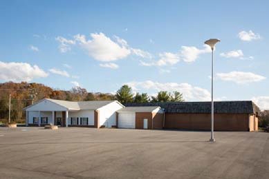
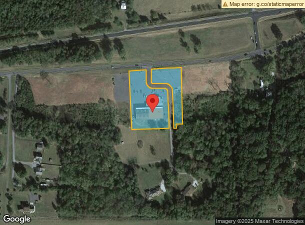
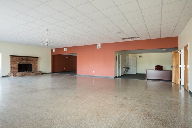
Property Record
2039 Us Highway 211 W, Luray, VA 22835
NEARBY LISTINGS FOR SALE OR LEASE
-
-
View all Luray listings for sale on LoopNet.com
Property Detail
2039 Us Highway 211 W
40-A-92F
INST#12-2017 INST#18-0550 #20-0371 INST#22-1705DE INST#22-1707 INST#22-1708 INST#23-1339-E
Commercialnec
Page
X
Virginia
51139C0070D
92
2024
2.61 AC
2024
Virginia Shenandoah Valley Regional
030200
Other Market Areas
16,053 SF
DEMOGRAPHICS near 2039 Us Highway 211 W
1 Mile
3 Mile
5 Mile
2024 Total Population
421
4,680
9,471
2029 Population
424
4,675
9,435
Pop Growth 2024-2029
+ 0.71%
(0.11%)
(0.38%)
Average Age
46
46
45
2024 Total Households
168
1,967
4,004
HH Growth 2024-2029
+ 0.60%
(0.10%)
(0.37%)
Median Household Inc
$48,999
$49,456
$51,752
Avg Household Size
2.30
2.30
2.30
2024 Avg HH Vehicles
2.00
2.00
2.00
Median Home Value
$208,537
$210,356
$220,251
Median Year Built
1958
1959
1966
Nearby Places
- Restaurants
- Banks
- Shops
- Fitness
- Groceries
SALE & LEASE HISTORY
LISTING DATE
SALE/LEASE

Sep 24, 2016
For Sale
Mar 27, 2017
For Sale
Mar 13, 2018
For Sale
Nearby Properties
Address
Land Use
TOTAL SIZE
Lot Size
Zoning
Address
Land Use
TOTAL SIZE
Lot Size
Zoning
5,640 SF
15.29 AC
B1
Address
Land Use
TOTAL SIZE
Lot Size
Zoning
123,000 SF
90.75 AC
RB1
Address
Land Use
TOTAL SIZE
Lot Size
Zoning
10,238 SF
95.01 AC
B1
Address
Land Use
TOTAL SIZE
Lot Size
Zoning
84,759 SF
0.16 AC
R2
Address
Land Use
TOTAL SIZE
Lot Size
Zoning
70,765 SF
0.16 AC
R4
Address
Land Use
TOTAL SIZE
Lot Size
Zoning
109,824 SF
7.79 AC
B1
Address
Land Use
TOTAL SIZE
Lot Size
Zoning
42,585 SF
8.76 AC
R3
Address
Land Use
TOTAL SIZE
Lot Size
Zoning
1,972 SF
81.81 AC
AC
Address
Land Use
TOTAL SIZE
Lot Size
Zoning
25,504 SF
1.12 AC
B1
Address
Land Use
TOTAL SIZE
Lot Size
Zoning
43,312 SF
10.10 AC
B1
Address
Land Use
TOTAL SIZE
Lot Size
Zoning
33,342 SF
8.93 AC
B1
Address
Land Use
TOTAL SIZE
Lot Size
Zoning
1,128 SF
42.03 AC
C COMMERCI
Address
Land Use
TOTAL SIZE
Lot Size
Zoning
9,504 SF
9.13 AC
R5 RESIDEN
Address
Land Use
TOTAL SIZE
Lot Size
Zoning
12,760 SF
8.30 AC
B1
Address
Land Use
TOTAL SIZE
Lot Size
Zoning
9,000 SF
5 AC
A AGRICULT
Address
Land Use
TOTAL SIZE
Lot Size
Zoning
7,560 SF
5.20 AC
B1
Address
Land Use
TOTAL SIZE
Lot Size
Zoning
22,076 SF
3.26 AC
R RESIDENT
Address
Land Use
TOTAL SIZE
Lot Size
Zoning
23,234 SF
1.28 AC
B1
Address
Land Use
TOTAL SIZE
Lot Size
Zoning
126,436 SF
9.42 AC
M1
Address
Land Use
TOTAL SIZE
Lot Size
Zoning
13.78 AC
A AGRICULT
Address
Land Use
TOTAL SIZE
Lot Size
Zoning
3,672 SF
97.26 AC
A AGRICULT
Address
Land Use
TOTAL SIZE
Lot Size
Zoning
13,360 SF
0.13 AC
B1
Address
Land Use
TOTAL SIZE
Lot Size
Zoning
2,646 SF
142.34 AC
A AGRICULT
Address
Land Use
TOTAL SIZE
Lot Size
Zoning
6,144 SF
0.56 AC
B1
Address
Land Use
TOTAL SIZE
Lot Size
Zoning
8,800 SF
1.10 AC
B1
Address
Land Use
TOTAL SIZE
Lot Size
Zoning
2,574 SF
181.23 AC
A AGRICULT
Address
Land Use
TOTAL SIZE
Lot Size
Zoning
2,511 SF
149.24 AC
A AGRICULT
Address
Land Use
TOTAL SIZE
Lot Size
Zoning
3,726 SF
2.29 AC
B1
Address
Land Use
TOTAL SIZE
Lot Size
Zoning
2,257 SF
111.56 AC
A AGRICULT
Address
Land Use
TOTAL SIZE
Lot Size
Zoning
11,200 SF
0.58 AC
R1
The World's #1 Commercial Real Estate Marketplace
Connect with us
© 2025 CoStar Group
The information above has been obtained from sources believed reliable. While we do not doubt its accuracy we have not verified it and make no guarantee, warranty or representation about it. It is your responsibility to independently confirm its accuracy and completeness. Any projections, opinions, assumptions, or estimates used are for example only and do not represent the current or future performance of the property. The value of this transaction to you depends on tax and other factors which should be evaluated by your tax, financial, and legal advisors. You and your advisors should conduct a careful, independent investigation of the property to determine to your satisfaction the suitability of the property for your needs.