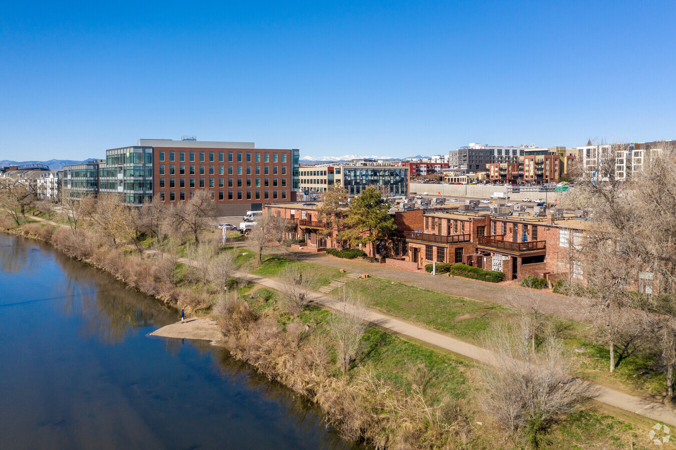
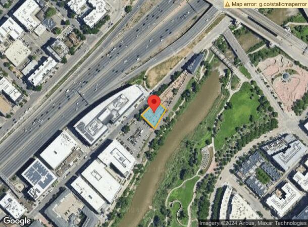
Property Record
1740 Platte St, Denver, CO 80202

Current Lease Availabilities
NEARBY LISTINGS FOR SALE OR LEASE
Property Detail
1740 Platte St
Denver-Aurora-Lakewood, CO
Central Sub
2284-06-012
CENTRAL SUB 02283 B20 L1 TO 3 INC EXC C&S ROW & S 50FT LYING N & W OF C&S ROW
Officebuilding
Denver
X
Colorado
0800460069J
1-3
2023
0.27 AC
2023
Platte River
0011023031
Denver
22,870 SF
DEMOGRAPHICS near 1740 Platte St
1 Mile
3 Mile
5 Mile
2024 Total Population
41,595
220,894
453,865
2029 Population
43,040
225,668
459,976
Pop Growth 2024-2029
+ 3.47%
+ 2.16%
+ 1.35%
Average Age
36
37
38
2024 Total Households
24,545
114,968
215,078
HH Growth 2024-2029
+ 3.39%
+ 2.20%
+ 1.41%
Median Household Inc
$99,629
$85,934
$81,080
Avg Household Size
1.60
1.80
2.00
2024 Avg HH Vehicles
1.00
1.00
2.00
Median Home Value
$769,662
$660,453
$616,314
Median Year Built
2010
1973
1966
Nearby Places
- Restaurants
- Banks
- Shops
- Fitness
- Groceries
PUBLIC TRANSPORTATION
TRANSIT/SUBWAY
Union Station Track 11 (Union Station to Jefferson County Government Center-Golden Station - Regional Transportation District, Union Station to RidgeGate Parkway Station - Regional Transportation District)
DRIVE
WALK
Distance
Union Station Track 11 (Union Station to Jefferson County Government Center-Golden Station - Regional Transportation District, Union Station to RidgeGate Parkway Station - Regional Transportation District)
3 min
10 min
0.6 mi
Union Station Track 12 (Union Station to Jefferson County Government Center-Golden Station - Regional Transportation District, Union Station to RidgeGate Parkway Station - Regional Transportation District)
DRIVE
WALK
Distance
Union Station Track 12 (Union Station to Jefferson County Government Center-Golden Station - Regional Transportation District, Union Station to RidgeGate Parkway Station - Regional Transportation District)
2 min
11 min
0.6 mi
Pepsi Center-Elitch Gardens (C Line - Denver Regional Transportation District Light Rail (TheRide), E Line - Denver Regional Transportation District Light Rail (TheRide), W Line - Denver Regional Transportation District Light Rail (TheRide))
DRIVE
WALK
Distance
Pepsi Center-Elitch Gardens (C Line - Denver Regional Transportation District Light Rail (TheRide), E Line - Denver Regional Transportation District Light Rail (TheRide), W Line - Denver Regional Transportation District Light Rail (TheRide))
4 min
20 min
1.0 mi
COMMUTER RAIL
Union Station: Lodo-Coors Field-16Th Street Mall (C Line - Denver Regional Transportation District Light Rail (TheRide), E Line - Denver Regional Transportation District Light Rail (TheRide), W Line - Denver Regional Transportation District Light Rail (TheRide))
DRIVE
WALK
Distance
Union Station: Lodo-Coors Field-16Th Street Mall (C Line - Denver Regional Transportation District Light Rail (TheRide), E Line - Denver Regional Transportation District Light Rail (TheRide), W Line - Denver Regional Transportation District Light Rail (TheRide))
2 min
12 min
0.6 mi
Denver (California Zephyr - Amtrak)
DRIVE
WALK
Distance
Denver (California Zephyr - Amtrak)
3 min
14 min
0.8 mi
AIRPORT
Denver International
DRIVE
WALK
Distance
Denver International
32 min
24.2 mi
Freight Ports
Tulsa Port Of Catoosa
DRIVE
WALK
Distance
Tulsa Port Of Catoosa
730 min
709.7 mi
Nearby Properties
Address
Land Use
TOTAL SIZE
Lot Size
Zoning
Address
Land Use
TOTAL SIZE
Lot Size
Zoning
2,424,680 SF
21.15 AC
D-TD
Address
Land Use
TOTAL SIZE
Lot Size
Zoning
1,721,086 SF
21.34 AC
C-MU-30
Address
Land Use
TOTAL SIZE
Lot Size
Zoning
1,323,471 SF
10.26 AC
CMP-H
Address
Land Use
TOTAL SIZE
Lot Size
Zoning
1,248,868 SF
0.90 AC
D-TD
Address
Land Use
TOTAL SIZE
Lot Size
Zoning
1,661,628 SF
1.56 AC
D-C
Address
Land Use
TOTAL SIZE
Lot Size
Zoning
1,567,575 SF
1.40 AC
D-C
Address
Land Use
TOTAL SIZE
Lot Size
Zoning
1,399,487 SF
16.14 AC
CMP-H
Address
Land Use
TOTAL SIZE
Lot Size
Zoning
1,312,939 SF
1.15 AC
D-C
Address
Land Use
TOTAL SIZE
Lot Size
Zoning
1,286,459 SF
2.44 AC
PUD
Address
Land Use
TOTAL SIZE
Lot Size
Zoning
784,978 SF
1.15 AC
D-C
Address
Land Use
TOTAL SIZE
Lot Size
Zoning
697,516 SF
3.05 AC
D-CV
Address
Land Use
TOTAL SIZE
Lot Size
Zoning
1,097,914 SF
0.23 AC
D-C
Address
Land Use
TOTAL SIZE
Lot Size
Zoning
688,230 SF
0.94 AC
PUD
Address
Land Use
TOTAL SIZE
Lot Size
Zoning
150,202 SF
13.24 AC
T-MU-30
Address
Land Use
TOTAL SIZE
Lot Size
Zoning
513,131 SF
0.57 AC
D-C
Address
Land Use
TOTAL SIZE
Lot Size
Zoning
1,563,630 SF
2.53 AC
D-C
Address
Land Use
TOTAL SIZE
Lot Size
Zoning
1,027,206 SF
2.44 AC
D-C
Address
Land Use
TOTAL SIZE
Lot Size
Zoning
892,018 SF
2.42 AC
D-C
Address
Land Use
TOTAL SIZE
Lot Size
Zoning
321,759 SF
0.88 AC
PUD
Address
Land Use
TOTAL SIZE
Lot Size
Zoning
405,974 SF
1.78 AC
PUD
Address
Land Use
TOTAL SIZE
Lot Size
Zoning
1,375,437 SF
2.46 AC
D-C
Address
Land Use
TOTAL SIZE
Lot Size
Zoning
492,926 SF
1.16 AC
PUD
Address
Land Use
TOTAL SIZE
Lot Size
Zoning
1,024,471 SF
2.45 AC
D-C
Address
Land Use
TOTAL SIZE
Lot Size
Zoning
1,114,003 SF
2.45 AC
D-C
Address
Land Use
TOTAL SIZE
Lot Size
Zoning
618,768 SF
1.23 AC
D-C
Address
Land Use
TOTAL SIZE
Lot Size
Zoning
778,340 SF
0.61 AC
D-C
Address
Land Use
TOTAL SIZE
Lot Size
Zoning
515,064 SF
1.25 AC
D-LD
Address
Land Use
TOTAL SIZE
Lot Size
Zoning
764,724 SF
1 AC
D-C
Address
Land Use
TOTAL SIZE
Lot Size
Zoning
937,062 SF
1.95 AC
D-C
Address
Land Use
TOTAL SIZE
Lot Size
Zoning
1,078,109 SF
36.79 AC
CMP-EI
The World's #1 Commercial Real Estate Marketplace
Connect with us
© 2025 CoStar Group
The information above has been obtained from sources believed reliable. While we do not doubt its accuracy we have not verified it and make no guarantee, warranty or representation about it. It is your responsibility to independently confirm its accuracy and completeness. Any projections, opinions, assumptions, or estimates used are for example only and do not represent the current or future performance of the property. The value of this transaction to you depends on tax and other factors which should be evaluated by your tax, financial, and legal advisors. You and your advisors should conduct a careful, independent investigation of the property to determine to your satisfaction the suitability of the property for your needs.