Property Record
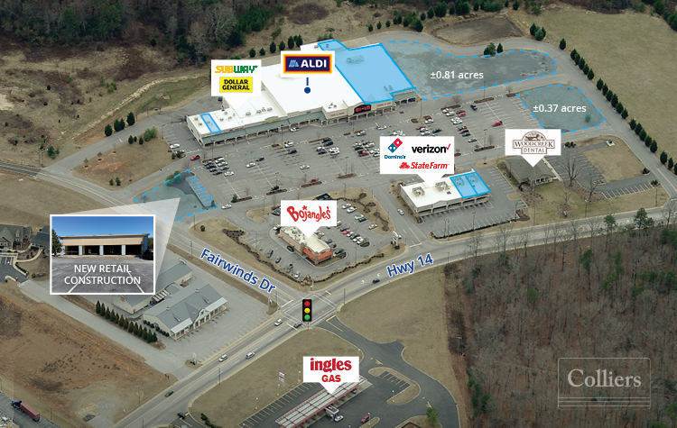
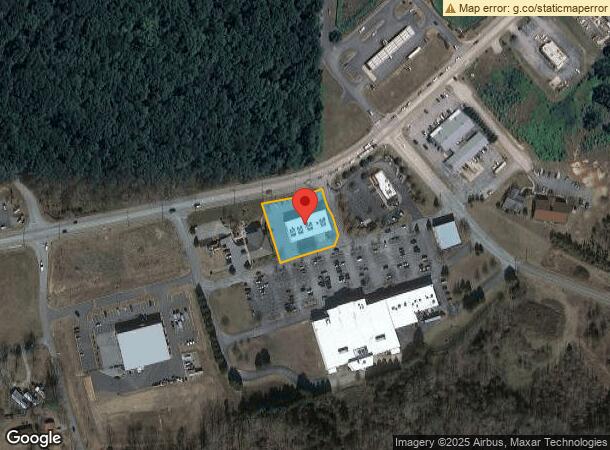
1736 Highway 14 E, Landrum, SC 29356
NEARBY LISTINGS FOR SALE OR LEASE
-
-
View all Landrum listings for lease on LoopNet.com
Property Detail
1736 Highway 14 E
Spartanburg, SC
Alta/Acsm Land Title Survey For 85 Llc
1-08-00-035.04
LOT 1 BOUNDRY SUR FOR 85 LLC PB 154-312 PB 170-751 DB 111D-717
Commercialnec
Spartanburg
X
South Carolina
45083C0016D
1
2024
0.87 AC
2024
Upper Spartanburg Cty
022600
Greenville/Spartanburg
8,174 SF
DEMOGRAPHICS near 1736 Highway 14 E
1 Mile
3 Mile
5 Mile
2024 Total Population
1,021
5,591
15,273
2029 Population
1,153
6,304
17,077
Pop Growth 2024-2029
+ 12.93%
+ 12.75%
+ 11.81%
Average Age
45
45
47
2024 Total Households
460
2,414
6,586
HH Growth 2024-2029
+ 13.26%
+ 12.92%
+ 11.87%
Median Household Inc
$40,900
$51,409
$54,706
Avg Household Size
2.20
2.30
2.30
2024 Avg HH Vehicles
2.00
2.00
2.00
Median Home Value
$195,925
$236,534
$265,231
Median Year Built
1971
1977
1982
Nearby Places
- Restaurants
- Banks
- Shops
- Fitness
- Groceries
PUBLIC TRANSPORTATION
AIRPORT
Greenville Spartanburg International
DRIVE
WALK
Distance
Greenville Spartanburg International
41 min
32.1 mi
Asheville Regional
DRIVE
WALK
Distance
Asheville Regional
40 min
32.5 mi
Freight Ports
North Charleston Terminal
DRIVE
WALK
Distance
North Charleston Terminal
236 min
212.9 mi
SALE & LEASE HISTORY
LISTING DATE
SALE/LEASE

Nov 26, 2019
For Lease
May 18, 2020
For Lease
Mar 25, 2021
For Lease
Aug 04, 2017
For Lease
Nearby Properties
Address
Land Use
TOTAL SIZE
Lot Size
Zoning
Address
Land Use
TOTAL SIZE
Lot Size
Zoning
166.74 AC
RE5
Address
Land Use
TOTAL SIZE
Lot Size
Zoning
7,703 SF
190.87 AC
RE5
Address
Land Use
TOTAL SIZE
Lot Size
Zoning
9,745 SF
10.01 AC
Address
Land Use
TOTAL SIZE
Lot Size
Zoning
2,812 SF
3.26 AC
RE5
Address
Land Use
TOTAL SIZE
Lot Size
Zoning
3,352 SF
7.54 AC
MX
Address
Land Use
TOTAL SIZE
Lot Size
Zoning
2,290 SF
23.19 AC
RE5
Address
Land Use
TOTAL SIZE
Lot Size
Zoning
13.05 AC
Address
Land Use
TOTAL SIZE
Lot Size
Zoning
2.43 AC
MX
Address
Land Use
TOTAL SIZE
Lot Size
Zoning
4.61 AC
RE5
Address
Land Use
TOTAL SIZE
Lot Size
Zoning
1,822 SF
12.75 AC
MX
Address
Land Use
TOTAL SIZE
Lot Size
Zoning
21.61 AC
RE5
Address
Land Use
TOTAL SIZE
Lot Size
Zoning
1,380 SF
30.08 AC
AR5
Address
Land Use
TOTAL SIZE
Lot Size
Zoning
1,410 SF
31.21 AC
RE5
Address
Land Use
TOTAL SIZE
Lot Size
Zoning
4,264 SF
1.13 AC
MX
Address
Land Use
TOTAL SIZE
Lot Size
Zoning
2.59 AC
Address
Land Use
TOTAL SIZE
Lot Size
Zoning
1,584 SF
8.79 AC
RE5
Address
Land Use
TOTAL SIZE
Lot Size
Zoning
22.88 AC
RE5
Address
Land Use
TOTAL SIZE
Lot Size
Zoning
69.07 AC
RE5
Address
Land Use
TOTAL SIZE
Lot Size
Zoning
8.57 AC
RE5
Address
Land Use
TOTAL SIZE
Lot Size
Zoning
3.64 AC
MX
Address
Land Use
TOTAL SIZE
Lot Size
Zoning
2,088 SF
102.29 AC
MX
Address
Land Use
TOTAL SIZE
Lot Size
Zoning
5.24 AC
RE5
Address
Land Use
TOTAL SIZE
Lot Size
Zoning
2.54 AC
MX
Address
Land Use
TOTAL SIZE
Lot Size
Zoning
18.58 AC
MX
Address
Land Use
TOTAL SIZE
Lot Size
Zoning
2.70 AC
MX
Address
Land Use
TOTAL SIZE
Lot Size
Zoning
19.25 AC
RE5
Address
Land Use
TOTAL SIZE
Lot Size
Zoning
Address
Land Use
TOTAL SIZE
Lot Size
Zoning
5.38 AC
MX
Address
Land Use
TOTAL SIZE
Lot Size
Zoning
1,953 SF
7.48 AC
RE5
Address
Land Use
TOTAL SIZE
Lot Size
Zoning
1,991 SF
2.10 AC
MX
The World's #1 Commercial Real Estate Marketplace
Connect with us
© 2025 CoStar Group
The information above has been obtained from sources believed reliable. While we do not doubt its accuracy we have not verified it and make no guarantee, warranty or representation about it. It is your responsibility to independently confirm its accuracy and completeness. Any projections, opinions, assumptions, or estimates used are for example only and do not represent the current or future performance of the property. The value of this transaction to you depends on tax and other factors which should be evaluated by your tax, financial, and legal advisors. You and your advisors should conduct a careful, independent investigation of the property to determine to your satisfaction the suitability of the property for your needs.