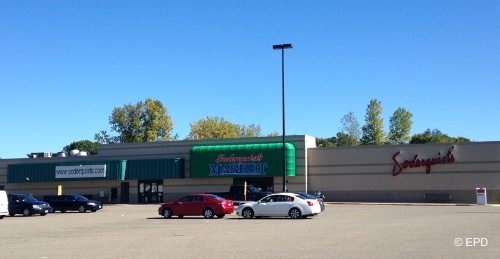
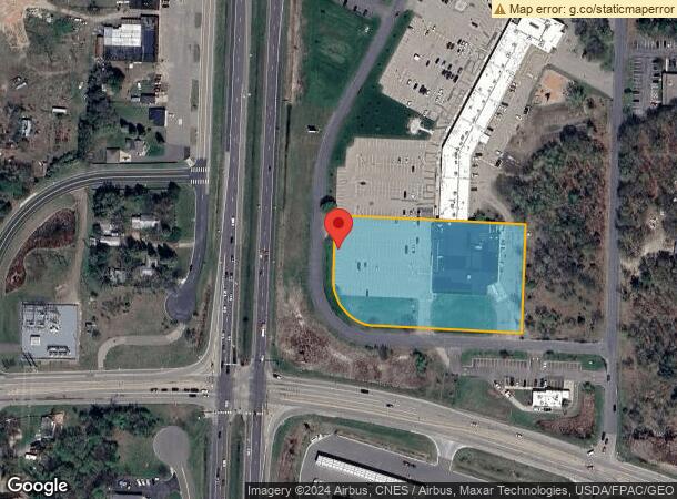
Property Record
17525 Highway 65 Ne, Andover, MN 55304
NEARBY LISTINGS FOR SALE OR LEASE
Property Detail
17525 Highway 65 Ne
Minneapolis-St. Paul-Bloomington, MN-WI
Crosstown Shopping Center
05-32-23-42-0008
CROSSTOWN SHOPPING CENTER LOT 2 BLK 2 CROSSTOWN SHOP CTR(SUBJ TO EASE AS SHOWN ON PLAT)
Taxexempt
Anoka
X
Minnesota
27003C0215E
2
2024
2.87 AC
2024
Coon Rapids
050235
Minneapolis/St Paul
28,303 SF
DEMOGRAPHICS near 17525 Highway 65 Ne
1 Mile
3 Mile
5 Mile
2024 Total Population
2,451
10,817
35,463
2029 Population
2,569
11,315
36,968
Pop Growth 2024-2029
+ 4.81%
+ 4.60%
+ 4.24%
Average Age
40
41
40
2024 Total Households
894
3,884
12,118
HH Growth 2024-2029
+ 4.81%
+ 4.61%
+ 4.27%
Median Household Inc
$77,312
$102,101
$119,806
Avg Household Size
2.70
2.80
2.90
2024 Avg HH Vehicles
2.00
3.00
3.00
Median Home Value
$297,263
$359,770
$383,639
Median Year Built
1982
1987
1994
Nearby Places
- Restaurants
- Banks
- Shops
- Fitness
- Groceries
PUBLIC TRANSPORTATION
AIRPORT
Minneapolis-St Paul International/Wold-Chamberlain
DRIVE
WALK
Distance
Minneapolis-St Paul International/Wold-Chamberlain
50 min
34.5 mi
Freight Ports
Port Milwaukee
DRIVE
WALK
Distance
Port Milwaukee
395 min
356.7 mi
SALE & LEASE HISTORY
LISTING DATE
SALE/LEASE

Sep 24, 2016
For Sale
Nearby Properties
Address
Land Use
TOTAL SIZE
Lot Size
Zoning
Address
Land Use
TOTAL SIZE
Lot Size
Zoning
5.98 AC
Address
Land Use
TOTAL SIZE
Lot Size
Zoning
63,671 SF
40 AC
Address
Land Use
TOTAL SIZE
Lot Size
Zoning
Address
Land Use
TOTAL SIZE
Lot Size
Zoning
102,360 SF
6.06 AC
Address
Land Use
TOTAL SIZE
Lot Size
Zoning
53,180 SF
30.46 AC
Address
Land Use
TOTAL SIZE
Lot Size
Zoning
32,000 SF
5.25 AC
Address
Land Use
TOTAL SIZE
Lot Size
Zoning
28,600 SF
4.37 AC
Address
Land Use
TOTAL SIZE
Lot Size
Zoning
22,185 SF
Address
Land Use
TOTAL SIZE
Lot Size
Zoning
62,624 SF
12 AC
Address
Land Use
TOTAL SIZE
Lot Size
Zoning
1,120 SF
6.02 AC
Address
Land Use
TOTAL SIZE
Lot Size
Zoning
37,048 SF
2.58 AC
Address
Land Use
TOTAL SIZE
Lot Size
Zoning
25,569 SF
2.20 AC
Address
Land Use
TOTAL SIZE
Lot Size
Zoning
22,400 SF
5.60 AC
Address
Land Use
TOTAL SIZE
Lot Size
Zoning
5,290 SF
2.80 AC
Address
Land Use
TOTAL SIZE
Lot Size
Zoning
36,159 SF
3.96 AC
Address
Land Use
TOTAL SIZE
Lot Size
Zoning
23,920 SF
2.83 AC
Address
Land Use
TOTAL SIZE
Lot Size
Zoning
14,580 SF
33.19 AC
Address
Land Use
TOTAL SIZE
Lot Size
Zoning
9,766 SF
67.67 AC
Address
Land Use
TOTAL SIZE
Lot Size
Zoning
17,100 SF
2.09 AC
Address
Land Use
TOTAL SIZE
Lot Size
Zoning
6,883 SF
2.63 AC
Address
Land Use
TOTAL SIZE
Lot Size
Zoning
19,792 SF
2 AC
Address
Land Use
TOTAL SIZE
Lot Size
Zoning
13,284 SF
2.15 AC
Address
Land Use
TOTAL SIZE
Lot Size
Zoning
11,094 SF
10.04 AC
Address
Land Use
TOTAL SIZE
Lot Size
Zoning
6,911 SF
3.21 AC
Address
Land Use
TOTAL SIZE
Lot Size
Zoning
17,144 SF
2.35 AC
Address
Land Use
TOTAL SIZE
Lot Size
Zoning
19,800 SF
2.32 AC
Address
Land Use
TOTAL SIZE
Lot Size
Zoning
33,605 SF
4.33 AC
Address
Land Use
TOTAL SIZE
Lot Size
Zoning
2.48 AC
Address
Land Use
TOTAL SIZE
Lot Size
Zoning
25,936 SF
24.35 AC
The World's #1 Commercial Real Estate Marketplace
Connect with us
© 2025 CoStar Group
The information above has been obtained from sources believed reliable. While we do not doubt its accuracy we have not verified it and make no guarantee, warranty or representation about it. It is your responsibility to independently confirm its accuracy and completeness. Any projections, opinions, assumptions, or estimates used are for example only and do not represent the current or future performance of the property. The value of this transaction to you depends on tax and other factors which should be evaluated by your tax, financial, and legal advisors. You and your advisors should conduct a careful, independent investigation of the property to determine to your satisfaction the suitability of the property for your needs.