Property Record
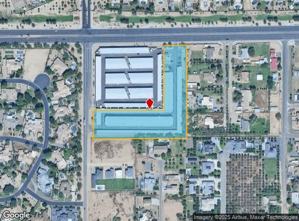
17635 E Riggs Rd, Queen Creek, AZ 85142
NEARBY LISTINGS FOR SALE OR LEASE
Property Detail
17635 E Riggs Rd
Phoenix-Mesa-Scottsdale, AZ
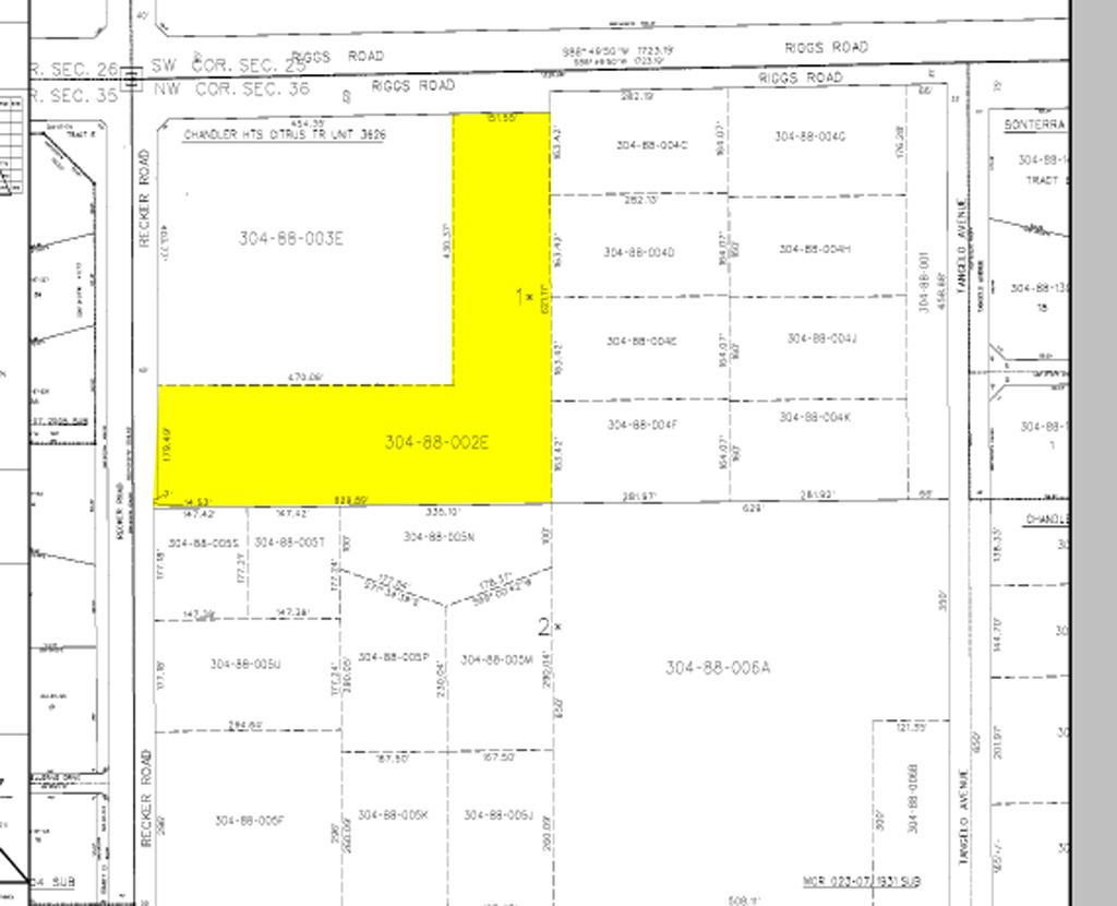
Chandler Heights Citrus Tract Unit 3626
304-88-002E
CHANDLER HTS CITRUS TR 3626 PT W2 LOT 1 DAF PT NW4 MORE PART DESC AS FOL COM NW COR SD SEC 36 TH N 88D E 663.44F TH S 33.05F TO POB TH S 653.08F TH W 629.89F TH N 194.14F TH E 477.04F TH N 462.27F TH N 88D E 151.44F TO POB P/F 09-0030019 EX ANY POR L
Publicstorage
Maricopa
X
Arizona
04013C3150L
1
2024
4.24 AC
2025
Gateway Airport/Loop 202
816502
Phoenix
114,522 SF
DEMOGRAPHICS near 17635 E Riggs Rd
1 Mile
3 Mile
5 Mile
2024 Total Population
6,798
45,302
135,696
2029 Population
7,409
49,371
147,665
Pop Growth 2024-2029
+ 8.99%
+ 8.98%
+ 8.82%
Average Age
38
38
37
2024 Total Households
2,098
14,050
40,881
HH Growth 2024-2029
+ 8.87%
+ 8.90%
+ 8.84%
Median Household Inc
$125,121
$126,699
$124,246
Avg Household Size
3.10
3.20
3.20
2024 Avg HH Vehicles
3.00
2.00
2.00
Median Home Value
$607,261
$541,168
$490,804
Median Year Built
2005
2007
2007
Nearby Places
- Restaurants
- Banks
- Shops
- Fitness
- Groceries
PUBLIC TRANSPORTATION
AIRPORT
Phoenix-Mesa Gateway
DRIVE
WALK
Distance
Phoenix-Mesa Gateway
15 min
8.0 mi
Phoenix Sky Harbor International
DRIVE
WALK
Distance
Phoenix Sky Harbor International
46 min
31.2 mi
Freight Ports
Port of San Diego
DRIVE
WALK
Distance
Port of San Diego
407 min
368.8 mi
Nearby Properties
Address
Land Use
TOTAL SIZE
Lot Size
Zoning
Address
Land Use
TOTAL SIZE
Lot Size
Zoning
339,494 SF
48.27 AC
R-4
Address
Land Use
TOTAL SIZE
Lot Size
Zoning
30,624 SF
13.41 AC
Address
Land Use
TOTAL SIZE
Lot Size
Zoning
139,348 SF
16.39 AC
R-12
Address
Land Use
TOTAL SIZE
Lot Size
Zoning
187,208 SF
34.75 AC
MDR
Address
Land Use
TOTAL SIZE
Lot Size
Zoning
103,423 SF
27.10 AC
PF
Address
Land Use
TOTAL SIZE
Lot Size
Zoning
85,775 SF
10.40 AC
PF
Address
Land Use
TOTAL SIZE
Lot Size
Zoning
117,552 SF
30.35 AC
R143
Address
Land Use
TOTAL SIZE
Lot Size
Zoning
92,160 SF
14.95 AC
PF
Address
Land Use
TOTAL SIZE
Lot Size
Zoning
100,758 SF
12.30 AC
R-7
Address
Land Use
TOTAL SIZE
Lot Size
Zoning
109,657 SF
11.71 AC
C-C
Address
Land Use
TOTAL SIZE
Lot Size
Zoning
61,641 SF
39.91 AC
PF
Address
Land Use
TOTAL SIZE
Lot Size
Zoning
88,288 SF
13.23 AC
SF7
Address
Land Use
TOTAL SIZE
Lot Size
Zoning
90,169 SF
10.98 AC
C-C
Address
Land Use
TOTAL SIZE
Lot Size
Zoning
57,816 SF
8.36 AC
PF/I
Address
Land Use
TOTAL SIZE
Lot Size
Zoning
49,300 SF
8.01 AC
SC
Address
Land Use
TOTAL SIZE
Lot Size
Zoning
135,670 SF
3.58 AC
GC
Address
Land Use
TOTAL SIZE
Lot Size
Zoning
1,767 SF
81.06 AC
PF
Address
Land Use
TOTAL SIZE
Lot Size
Zoning
54,689 SF
29.59 AC
R-43
Address
Land Use
TOTAL SIZE
Lot Size
Zoning
108.04 AC
PF
Address
Land Use
TOTAL SIZE
Lot Size
Zoning
55,425 SF
4.64 AC
R-43
Address
Land Use
TOTAL SIZE
Lot Size
Zoning
44,008 SF
6.50 AC
C-N
Address
Land Use
TOTAL SIZE
Lot Size
Zoning
84,531 SF
5.75 AC
C-C
Address
Land Use
TOTAL SIZE
Lot Size
Zoning
67,471 SF
15.20 AC
PF
Address
Land Use
TOTAL SIZE
Lot Size
Zoning
36.72 AC
PF
Address
Land Use
TOTAL SIZE
Lot Size
Zoning
15,409 SF
23.19 AC
R143
Address
Land Use
TOTAL SIZE
Lot Size
Zoning
21,609 SF
10.53 AC
C-C
Address
Land Use
TOTAL SIZE
Lot Size
Zoning
16,626 SF
4.77 AC
PF
Address
Land Use
TOTAL SIZE
Lot Size
Zoning
23,766 SF
5.41 AC
R-43
Address
Land Use
TOTAL SIZE
Lot Size
Zoning
32.30 AC
R-43
The World's #1 Commercial Real Estate Marketplace
Connect with us
© 2025 CoStar Group
The information above has been obtained from sources believed reliable. While we do not doubt its accuracy we have not verified it and make no guarantee, warranty or representation about it. It is your responsibility to independently confirm its accuracy and completeness. Any projections, opinions, assumptions, or estimates used are for example only and do not represent the current or future performance of the property. The value of this transaction to you depends on tax and other factors which should be evaluated by your tax, financial, and legal advisors. You and your advisors should conduct a careful, independent investigation of the property to determine to your satisfaction the suitability of the property for your needs.