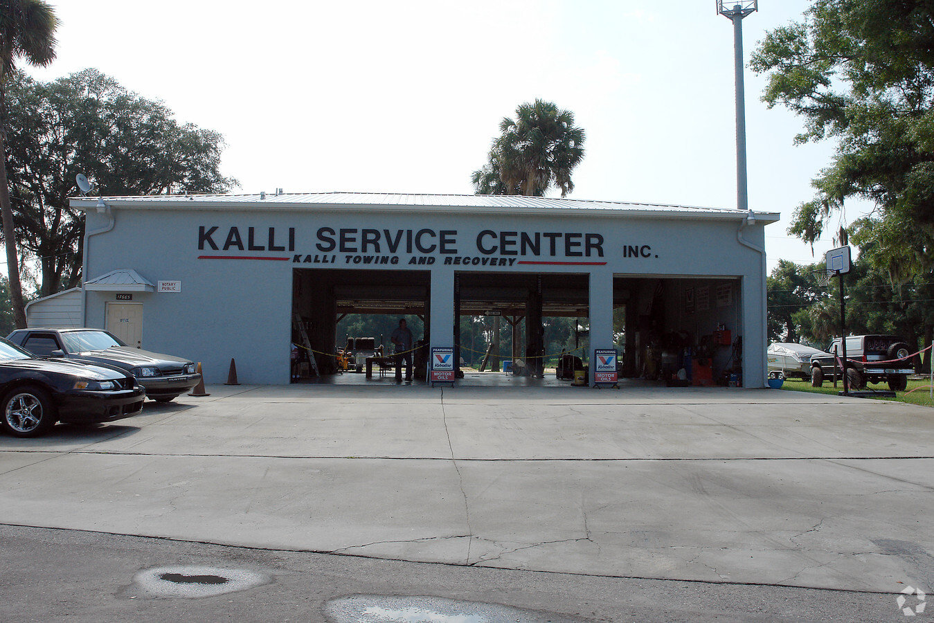
Property Record
17665 N Us Highway 301, Citra, FL 32113
Current Lease Availabilities
NEARBY LISTINGS FOR SALE OR LEASE
-
-
View all Citra listings for lease on LoopNet.com
Property Detail
17665 N Us Highway 301
Ocala, FL
301 North
03662-000-00
SEC 33 TWP 12 RGE 22 PLAT BOOK S PAGE 010 301 NORTH BLKA LOTS 1.2.4.5.6 BEING MORE PARTICULARLY DESC AS: COM AT THE NE COR OF SW 1/4 OF NE 1/4 OF SEC 33 TH N 89-43-41 W 297 FT TO THE POB TH CONT N 89-43-41 W 259.01 FT TO ELY ROW LINE U.S. HWY 301 TH
Publicstorage
Marion
X
Florida
12083C0165D
1
2023
8.95 AC
2023
Outlying Marion County
000201
Ocala
22,200 SF
DEMOGRAPHICS near 17665 N Us Highway 301
1 Mile
3 Mile
5 Mile
2024 Total Population
777
4,063
7,811
2029 Population
886
4,643
8,830
Pop Growth 2024-2029
+ 14.03%
+ 14.28%
+ 13.05%
Average Age
43
43
44
2024 Total Households
312
1,641
3,178
HH Growth 2024-2029
+ 13.78%
+ 14.26%
+ 12.93%
Median Household Inc
$27,647
$36,948
$46,041
Avg Household Size
2.50
2.40
2.40
2024 Avg HH Vehicles
2.00
2.00
2.00
Median Home Value
$300,467
$124,242
$187,001
Median Year Built
1984
1986
1986
Nearby Places
- Restaurants
- Banks
- Shops
- Fitness
- Groceries
PUBLIC TRANSPORTATION
AIRPORT
Gainesville Regional
DRIVE
WALK
Distance
Gainesville Regional
46 min
32.4 mi
Freight Ports
Jacksonville Port
DRIVE
WALK
Distance
Jacksonville Port
113 min
89.1 mi
Nearby Properties
Address
Land Use
TOTAL SIZE
Lot Size
Zoning
Address
Land Use
TOTAL SIZE
Lot Size
Zoning
86,722 SF
30.19 AC
A1
Address
Land Use
TOTAL SIZE
Lot Size
Zoning
40,022 SF
61 AC
A1
Address
Land Use
TOTAL SIZE
Lot Size
Zoning
5,358 SF
61.73 AC
GU
Address
Land Use
TOTAL SIZE
Lot Size
Zoning
21,000 SF
8.95 AC
B4
Address
Land Use
TOTAL SIZE
Lot Size
Zoning
10,046 SF
763.29 AC
A1
Address
Land Use
TOTAL SIZE
Lot Size
Zoning
12,500 SF
7.75 AC
B5
Address
Land Use
TOTAL SIZE
Lot Size
Zoning
8,381 SF
1.82 AC
A1
Address
Land Use
TOTAL SIZE
Lot Size
Zoning
7,131 SF
294 AC
A1
Address
Land Use
TOTAL SIZE
Lot Size
Zoning
7,305 SF
56.85 AC
A1
Address
Land Use
TOTAL SIZE
Lot Size
Zoning
8,320 SF
1.09 AC
B4
Address
Land Use
TOTAL SIZE
Lot Size
Zoning
22,080 SF
3.05 AC
B4
Address
Land Use
TOTAL SIZE
Lot Size
Zoning
4,753 SF
4.82 AC
B4
Address
Land Use
TOTAL SIZE
Lot Size
Zoning
5,400 SF
3 AC
B2
Address
Land Use
TOTAL SIZE
Lot Size
Zoning
5,225 SF
560.95 AC
A1
Address
Land Use
TOTAL SIZE
Lot Size
Zoning
4,242 SF
25.77 AC
A1
Address
Land Use
TOTAL SIZE
Lot Size
Zoning
4,965 SF
1.53 AC
B4
Address
Land Use
TOTAL SIZE
Lot Size
Zoning
8,000 SF
1 AC
B4
Address
Land Use
TOTAL SIZE
Lot Size
Zoning
3,360 SF
0.65 AC
B4
Address
Land Use
TOTAL SIZE
Lot Size
Zoning
768 SF
6.26 AC
RR
Address
Land Use
TOTAL SIZE
Lot Size
Zoning
6,158 SF
3.50 AC
B4
Address
Land Use
TOTAL SIZE
Lot Size
Zoning
6,224 SF
10 AC
M1
Address
Land Use
TOTAL SIZE
Lot Size
Zoning
1,148 SF
29.93 AC
A1
Address
Land Use
TOTAL SIZE
Lot Size
Zoning
2,999 SF
21.35 AC
A1
Address
Land Use
TOTAL SIZE
Lot Size
Zoning
10,550 SF
4.07 AC
B4
Address
Land Use
TOTAL SIZE
Lot Size
Zoning
2,113 SF
5 AC
A1
Address
Land Use
TOTAL SIZE
Lot Size
Zoning
6,238 SF
2.38 AC
B4
Address
Land Use
TOTAL SIZE
Lot Size
Zoning
2,040 SF
9.49 AC
A1
Address
Land Use
TOTAL SIZE
Lot Size
Zoning
5,609 SF
4.11 AC
A1
Address
Land Use
TOTAL SIZE
Lot Size
Zoning
3,242 SF
3.30 AC
B4
Address
Land Use
TOTAL SIZE
Lot Size
Zoning
3,343 SF
0.70 AC
B4
The World's #1 Commercial Real Estate Marketplace
Connect with us
© 2025 CoStar Group
The information above has been obtained from sources believed reliable. While we do not doubt its accuracy we have not verified it and make no guarantee, warranty or representation about it. It is your responsibility to independently confirm its accuracy and completeness. Any projections, opinions, assumptions, or estimates used are for example only and do not represent the current or future performance of the property. The value of this transaction to you depends on tax and other factors which should be evaluated by your tax, financial, and legal advisors. You and your advisors should conduct a careful, independent investigation of the property to determine to your satisfaction the suitability of the property for your needs.