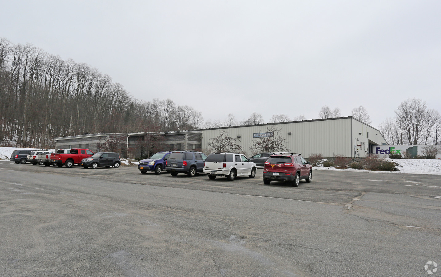
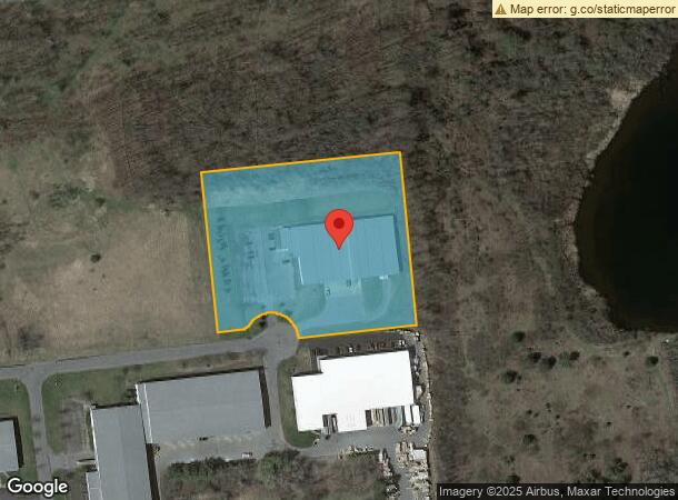
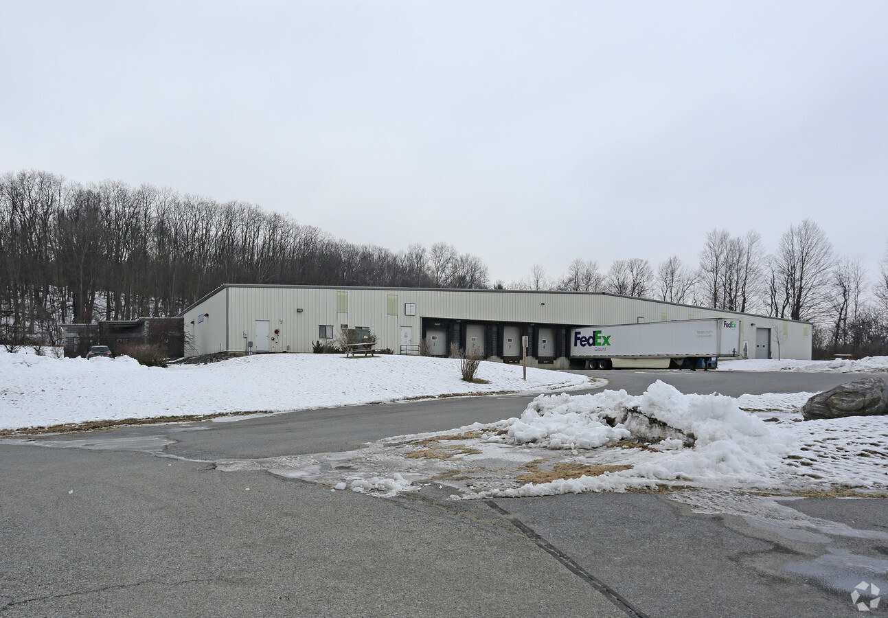
Property Record
179 Corporate Dr, Johnstown, NY 12095
NEARBY LISTINGS FOR SALE OR LEASE
Property Detail
179 Corporate Dr
Gloversville, NY
Fulton
170500-163-010-0002-009-000-0000
New York
Manufacturinglight
9.000
2023
5.20 AC
2023
Fulton County
970800
Albany/Schenectady/Troy
42,000 SF
DEMOGRAPHICS near 179 Corporate Dr
1 Mile
3 Mile
5 Mile
2024 Total Population
325
22,985
29,964
2029 Population
318
22,283
29,159
Pop Growth 2024-2029
(2.15%)
(3.05%)
(2.69%)
Average Age
43
41
42
2024 Total Households
109
9,776
12,569
HH Growth 2024-2029
(1.83%)
(3.07%)
(2.70%)
Median Household Inc
$62,500
$49,853
$52,564
Avg Household Size
2.30
2.20
2.20
2024 Avg HH Vehicles
2.00
2.00
2.00
Median Home Value
$145,238
$103,021
$120,050
Median Year Built
1964
1947
1948
Nearby Places
- Restaurants
- Banks
- Shops
- Fitness
- Groceries
PUBLIC TRANSPORTATION
COMMUTER RAIL
Amsterdam (Toronto - New York - VIA Rail)
DRIVE
WALK
Distance
Amsterdam (Toronto - New York - VIA Rail)
15 min
9.3 mi
Amsterdam Amtrak Station (Empire Service - Amtrak, Maple Leaf - Amtrak)
DRIVE
WALK
Distance
Amsterdam Amtrak Station (Empire Service - Amtrak, Maple Leaf - Amtrak)
15 min
9.3 mi
Freight Ports
Albany, NY Port
DRIVE
WALK
Distance
Albany, NY Port
64 min
46.7 mi
SALE & LEASE HISTORY
LISTING DATE
SALE/LEASE

Dec 27, 2019
For Sale
Nearby Properties
Address
Land Use
TOTAL SIZE
Lot Size
Zoning
Address
Land Use
TOTAL SIZE
Lot Size
Zoning
155,394 SF
83.80 AC
R2
Address
Land Use
TOTAL SIZE
Lot Size
Zoning
67,849 SF
18.80 AC
06 - INDUS
Address
Land Use
TOTAL SIZE
Lot Size
Zoning
65,000 SF
14.35 AC
01 - NOT Z
Address
Land Use
TOTAL SIZE
Lot Size
Zoning
Address
Land Use
TOTAL SIZE
Lot Size
Zoning
151,246 SF
31.20 AC
M
Address
Land Use
TOTAL SIZE
Lot Size
Zoning
1,200 SF
28.50 AC
RA
Address
Land Use
TOTAL SIZE
Lot Size
Zoning
198,064 SF
40.70 AC
08 - GOVER
Address
Land Use
TOTAL SIZE
Lot Size
Zoning
166,664 SF
15.20 AC
06 - INDUS
Address
Land Use
TOTAL SIZE
Lot Size
Zoning
68,106 SF
15.80 AC
08 - GOVER
Address
Land Use
TOTAL SIZE
Lot Size
Zoning
72,560 SF
2.10 AC
C
Address
Land Use
TOTAL SIZE
Lot Size
Zoning
67,650 SF
1.55 AC
C
Address
Land Use
TOTAL SIZE
Lot Size
Zoning
20,030 SF
3.60 AC
C
Address
Land Use
TOTAL SIZE
Lot Size
Zoning
11,456 SF
7.80 AC
RB
Address
Land Use
TOTAL SIZE
Lot Size
Zoning
51,200 SF
4.60 AC
06 - INDUS
Address
Land Use
TOTAL SIZE
Lot Size
Zoning
36,000 SF
7.10 AC
05 - COMME
Address
Land Use
TOTAL SIZE
Lot Size
Zoning
120,454 SF
14.30 AC
06 - INDUS
Address
Land Use
TOTAL SIZE
Lot Size
Zoning
36,755 SF
1.70 AC
RC
Address
Land Use
TOTAL SIZE
Lot Size
Zoning
Address
Land Use
TOTAL SIZE
Lot Size
Zoning
2.30 AC
M1
Address
Land Use
TOTAL SIZE
Lot Size
Zoning
9,074 SF
30.80 AC
C
Address
Land Use
TOTAL SIZE
Lot Size
Zoning
45,988 SF
1.80 AC
08 - GOVER
Address
Land Use
TOTAL SIZE
Lot Size
Zoning
44,128 SF
5 AC
C1
Address
Land Use
TOTAL SIZE
Lot Size
Zoning
Address
Land Use
TOTAL SIZE
Lot Size
Zoning
54,164 SF
25 AC
R1
Address
Land Use
TOTAL SIZE
Lot Size
Zoning
Address
Land Use
TOTAL SIZE
Lot Size
Zoning
6,465 SF
8.80 AC
RB
Address
Land Use
TOTAL SIZE
Lot Size
Zoning
43,891 SF
5.63 AC
C
Address
Land Use
TOTAL SIZE
Lot Size
Zoning
29,848 SF
3.30 AC
R1
Address
Land Use
TOTAL SIZE
Lot Size
Zoning
18 AC
R1
Address
Land Use
TOTAL SIZE
Lot Size
Zoning
The World's #1 Commercial Real Estate Marketplace
Connect with us
© 2025 CoStar Group
The information above has been obtained from sources believed reliable. While we do not doubt its accuracy we have not verified it and make no guarantee, warranty or representation about it. It is your responsibility to independently confirm its accuracy and completeness. Any projections, opinions, assumptions, or estimates used are for example only and do not represent the current or future performance of the property. The value of this transaction to you depends on tax and other factors which should be evaluated by your tax, financial, and legal advisors. You and your advisors should conduct a careful, independent investigation of the property to determine to your satisfaction the suitability of the property for your needs.