Property Record
179 Fire Tower Rd, Milford, PA 18337

NEARBY LISTINGS FOR SALE OR LEASE
-
-
View all Milford listings for sale on LoopNet.com
Property Detail
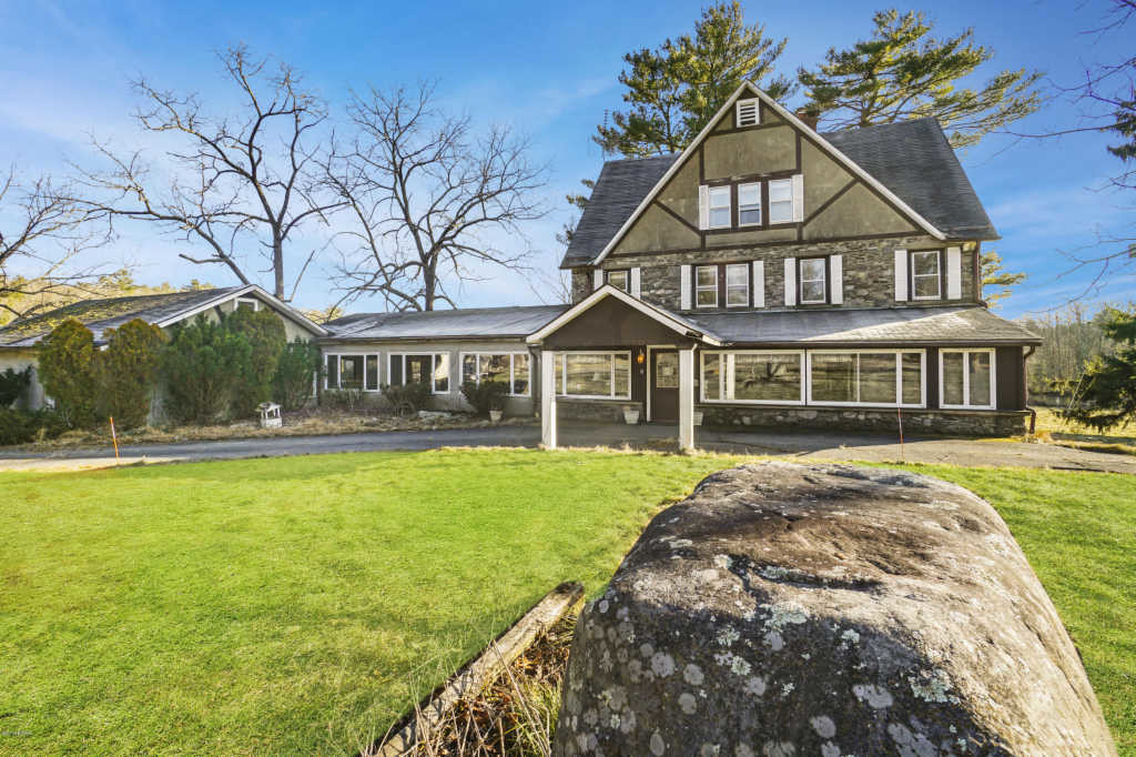
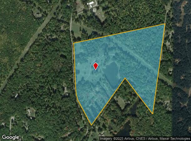
179 Fire Tower Rd
000649
Lands Surveyed For Edwin Jankoswki
Agriculturalland
46.28 AC 3 AC LAKE ACT 319 HSE BARN CABIN GIFT SHOP SHED
X
Pike
42103C0330C
Pennsylvania
2024
49.28 AC
2024
Pike County
950601
Northern New Jersey
9,172 SF
Newark, NJ-PA
DEMOGRAPHICS near 179 Fire Tower Rd
1 Mile
3 Mile
5 Mile
2024 Total Population
323
3,194
9,412
2029 Population
332
3,332
9,750
Pop Growth 2024-2029
+ 2.79%
+ 4.32%
+ 3.59%
Average Age
45
47
46
2024 Total Households
128
1,428
3,919
HH Growth 2024-2029
+ 2.34%
+ 4.41%
+ 3.57%
Median Household Inc
$82,291
$66,969
$81,748
Avg Household Size
2.50
2.20
2.30
2024 Avg HH Vehicles
2.00
2.00
2.00
Median Home Value
$283,783
$282,969
$263,727
Median Year Built
1981
1979
1984
Nearby Places
- Restaurants
- Banks
- Shops
- Fitness
- Groceries
SALE & LEASE HISTORY
LISTING DATE
SALE/LEASE

Nov 13, 2017
For Sale
Dec 19, 2018
For Sale
Nearby Properties
Address
Land Use
TOTAL SIZE
Lot Size
Zoning
Address
Land Use
TOTAL SIZE
Lot Size
Zoning
189,132 SF
27.19 AC
Address
Land Use
TOTAL SIZE
Lot Size
Zoning
37,089 SF
0.95 AC
Address
Land Use
TOTAL SIZE
Lot Size
Zoning
58,533 SF
0.68 AC
Address
Land Use
TOTAL SIZE
Lot Size
Zoning
23,368 SF
1.85 AC
Address
Land Use
TOTAL SIZE
Lot Size
Zoning
34,650 SF
10.50 AC
Address
Land Use
TOTAL SIZE
Lot Size
Zoning
41,025 SF
0.65 AC
Address
Land Use
TOTAL SIZE
Lot Size
Zoning
23,726 SF
964.40 AC
Address
Land Use
TOTAL SIZE
Lot Size
Zoning
33,104 SF
101.77 AC
Address
Land Use
TOTAL SIZE
Lot Size
Zoning
22,500 SF
1.94 AC
Address
Land Use
TOTAL SIZE
Lot Size
Zoning
26,138 SF
6.25 AC
Address
Land Use
TOTAL SIZE
Lot Size
Zoning
3,744 SF
1,201.95 AC
Address
Land Use
TOTAL SIZE
Lot Size
Zoning
21,568 SF
6.39 AC
Address
Land Use
TOTAL SIZE
Lot Size
Zoning
13,459 SF
6.88 AC
Address
Land Use
TOTAL SIZE
Lot Size
Zoning
36,800 SF
3.16 AC
Address
Land Use
TOTAL SIZE
Lot Size
Zoning
11,433 SF
3.26 AC
Address
Land Use
TOTAL SIZE
Lot Size
Zoning
16,387 SF
2.75 AC
Address
Land Use
TOTAL SIZE
Lot Size
Zoning
37,265 SF
139.11 AC
Address
Land Use
TOTAL SIZE
Lot Size
Zoning
1,326 SF
1.53 AC
Address
Land Use
TOTAL SIZE
Lot Size
Zoning
11,266 SF
3.76 AC
Address
Land Use
TOTAL SIZE
Lot Size
Zoning
13,771 SF
7 AC
Address
Land Use
TOTAL SIZE
Lot Size
Zoning
8,497 SF
9.61 AC
Address
Land Use
TOTAL SIZE
Lot Size
Zoning
11,332 SF
0.80 AC
Address
Land Use
TOTAL SIZE
Lot Size
Zoning
8,370 SF
1.65 AC
Address
Land Use
TOTAL SIZE
Lot Size
Zoning
5,740 SF
1.15 AC
Address
Land Use
TOTAL SIZE
Lot Size
Zoning
12,052 SF
1.29 AC
Address
Land Use
TOTAL SIZE
Lot Size
Zoning
16,440 SF
1.02 AC
Address
Land Use
TOTAL SIZE
Lot Size
Zoning
20,888 SF
2.81 AC
Address
Land Use
TOTAL SIZE
Lot Size
Zoning
22,800 SF
2.11 AC
Address
Land Use
TOTAL SIZE
Lot Size
Zoning
3,212 SF
14.30 AC
Address
Land Use
TOTAL SIZE
Lot Size
Zoning
24,860 SF
3.02 AC
The World's #1 Commercial Real Estate Marketplace
Connect with us
© 2025 CoStar Group
The information above has been obtained from sources believed reliable. While we do not doubt its accuracy we have not verified it and make no guarantee, warranty or representation about it. It is your responsibility to independently confirm its accuracy and completeness. Any projections, opinions, assumptions, or estimates used are for example only and do not represent the current or future performance of the property. The value of this transaction to you depends on tax and other factors which should be evaluated by your tax, financial, and legal advisors. You and your advisors should conduct a careful, independent investigation of the property to determine to your satisfaction the suitability of the property for your needs.