Property Record
179 Kings Nursery Rd, Greensburg, PA 15601
NEARBY LISTINGS FOR SALE OR LEASE
Property Detail
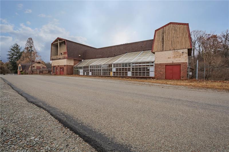
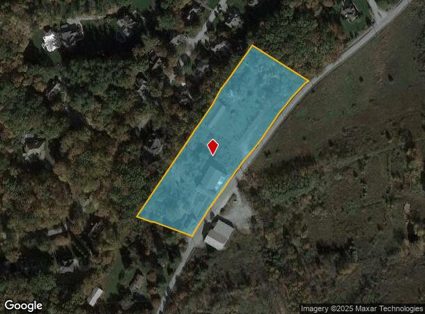
179 Kings Nursery Rd
61-17-00-0-105
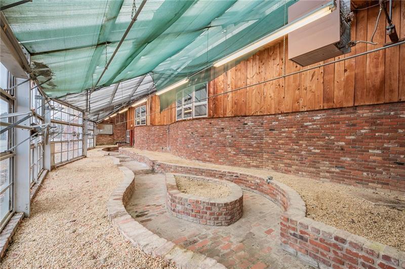
VACANT STORE, BLDG, GARDEN CTR KING SUB AG SEC AREA, 2 S BR
Commercialnec
Westmoreland
X
Pennsylvania
42129C0440F
5.35 AC
2024
Westmoreland County
2024
Pittsburgh
807201
Pittsburgh, PA
14,750 SF
DEMOGRAPHICS near 179 Kings Nursery Rd
1 Mile
3 Mile
5 Mile
2024 Total Population
3,201
24,292
59,635
2029 Population
3,158
24,006
58,982
Pop Growth 2024-2029
(1.34%)
(1.18%)
(1.09%)
Average Age
47
46
45
2024 Total Households
1,388
10,604
25,377
HH Growth 2024-2029
(1.37%)
(1.22%)
(1.15%)
Median Household Inc
$92,125
$73,812
$65,042
Avg Household Size
2.30
2.20
2.20
2024 Avg HH Vehicles
2.00
2.00
2.00
Median Home Value
$247,953
$214,019
$193,966
Median Year Built
1972
1970
1969
Nearby Places
- Restaurants
- Banks
- Shops
- Fitness
- Groceries
PUBLIC TRANSPORTATION
COMMUTER RAIL
Greensburg Amtrak (Pennsylvanian - Amtrak)
DRIVE
WALK
Distance
Greensburg Amtrak (Pennsylvanian - Amtrak)
9 min
4.8 mi
Latrobe Amtrak (Pennsylvanian - Amtrak)
DRIVE
WALK
Distance
Latrobe Amtrak (Pennsylvanian - Amtrak)
22 min
9.4 mi
AIRPORT
Arnold Palmer Regional
DRIVE
WALK
Distance
Arnold Palmer Regional
16 min
8.1 mi
Freight Ports
Port of Baltimore
DRIVE
WALK
Distance
Port of Baltimore
267 min
218.3 mi
SALE & LEASE HISTORY
LISTING DATE
SALE/LEASE

Nov 24, 2020
For Sale
May 05, 2022
For Sale
Feb 05, 2020
For Sale
Nearby Properties
Address
Land Use
TOTAL SIZE
Lot Size
Zoning
Address
Land Use
TOTAL SIZE
Lot Size
Zoning
Address
Land Use
TOTAL SIZE
Lot Size
Zoning
21.93 AC
Address
Land Use
TOTAL SIZE
Lot Size
Zoning
249,500 SF
24.75 AC
Address
Land Use
TOTAL SIZE
Lot Size
Zoning
133.04 AC
Address
Land Use
TOTAL SIZE
Lot Size
Zoning
116.20 AC
Address
Land Use
TOTAL SIZE
Lot Size
Zoning
21.60 AC
Address
Land Use
TOTAL SIZE
Lot Size
Zoning
Address
Land Use
TOTAL SIZE
Lot Size
Zoning
118,045 SF
16 AC
Address
Land Use
TOTAL SIZE
Lot Size
Zoning
133,122 SF
36.69 AC
Address
Land Use
TOTAL SIZE
Lot Size
Zoning
5.70 AC
Address
Land Use
TOTAL SIZE
Lot Size
Zoning
92,154 SF
14.11 AC
Address
Land Use
TOTAL SIZE
Lot Size
Zoning
86.43 AC
Address
Land Use
TOTAL SIZE
Lot Size
Zoning
115,844 SF
14.57 AC
Address
Land Use
TOTAL SIZE
Lot Size
Zoning
11.14 AC
Address
Land Use
TOTAL SIZE
Lot Size
Zoning
Address
Land Use
TOTAL SIZE
Lot Size
Zoning
10.41 AC
Address
Land Use
TOTAL SIZE
Lot Size
Zoning
5.20 AC
Address
Land Use
TOTAL SIZE
Lot Size
Zoning
14.90 AC
Address
Land Use
TOTAL SIZE
Lot Size
Zoning
Address
Land Use
TOTAL SIZE
Lot Size
Zoning
Address
Land Use
TOTAL SIZE
Lot Size
Zoning
Address
Land Use
TOTAL SIZE
Lot Size
Zoning
Address
Land Use
TOTAL SIZE
Lot Size
Zoning
49,027 SF
11.30 AC
Address
Land Use
TOTAL SIZE
Lot Size
Zoning
8.20 AC
Address
Land Use
TOTAL SIZE
Lot Size
Zoning
Address
Land Use
TOTAL SIZE
Lot Size
Zoning
38,240 SF
9.70 AC
Address
Land Use
TOTAL SIZE
Lot Size
Zoning
42,357 SF
10 AC
Address
Land Use
TOTAL SIZE
Lot Size
Zoning
Address
Land Use
TOTAL SIZE
Lot Size
Zoning
60,000 SF
14.84 AC
Address
Land Use
TOTAL SIZE
Lot Size
Zoning
3,429 SF
3.05 AC
The World's #1 Commercial Real Estate Marketplace
Connect with us
© 2025 CoStar Group
The information above has been obtained from sources believed reliable. While we do not doubt its accuracy we have not verified it and make no guarantee, warranty or representation about it. It is your responsibility to independently confirm its accuracy and completeness. Any projections, opinions, assumptions, or estimates used are for example only and do not represent the current or future performance of the property. The value of this transaction to you depends on tax and other factors which should be evaluated by your tax, financial, and legal advisors. You and your advisors should conduct a careful, independent investigation of the property to determine to your satisfaction the suitability of the property for your needs.