Property Record
180 Poverty Hill Cir, Carthage, NC 28327
NEARBY LISTINGS FOR SALE OR LEASE
Property Detail
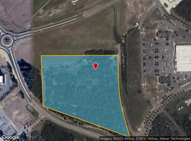
180 Poverty Hill Cir
8583-09-07-7445
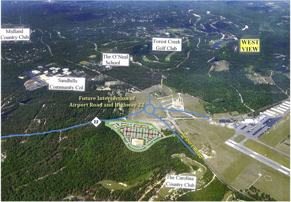
AIRPORT
Farms
Moore
X
North Carolina
3710858300J
12.50 AC
0
North Carolina Southeast Area
2024
Other Market Areas
9508022
Pinehurst-Southern Pines, NC
2,649 SF
DEMOGRAPHICS near 180 Poverty Hill Cir
1 Mile
3 Mile
5 Mile
2024 Total Population
1,085
16,917
42,255
2029 Population
1,252
19,565
48,878
Pop Growth 2024-2029
+ 15.39%
+ 15.65%
+ 15.67%
Average Age
45
45
44
2024 Total Households
489
7,283
18,736
HH Growth 2024-2029
+ 15.95%
+ 16.00%
+ 16.02%
Median Household Inc
$80,585
$84,072
$74,886
Avg Household Size
2.20
2.30
2.20
2024 Avg HH Vehicles
2.00
2.00
2.00
Median Home Value
$360,869
$374,566
$363,154
Median Year Built
1997
1999
1996
Nearby Places
- Restaurants
- Banks
- Shops
- Fitness
- Groceries
PUBLIC TRANSPORTATION
COMMUTER RAIL
Southern Pines Amtrak Station (Silver Star - Amtrak)
DRIVE
WALK
Distance
Southern Pines Amtrak Station (Silver Star - Amtrak)
8 min
4.2 mi
Freight Ports
Port of Wilmington
DRIVE
WALK
Distance
Port of Wilmington
175 min
138.5 mi
Nearby Properties
Address
Land Use
TOTAL SIZE
Lot Size
Zoning
Address
Land Use
TOTAL SIZE
Lot Size
Zoning
24,520 SF
94.90 AC
PPCC
Address
Land Use
TOTAL SIZE
Lot Size
Zoning
30,190 SF
181.04 AC
PPC
Address
Land Use
TOTAL SIZE
Lot Size
Zoning
39.86 AC
Address
Land Use
TOTAL SIZE
Lot Size
Zoning
24,942 SF
39.99 AC
MULTI
Address
Land Use
TOTAL SIZE
Lot Size
Zoning
15,900 SF
179.30 AC
MULTI
Address
Land Use
TOTAL SIZE
Lot Size
Zoning
15,422 SF
35.21 AC
R20
Address
Land Use
TOTAL SIZE
Lot Size
Zoning
8,118 SF
16.80 AC
PPC
Address
Land Use
TOTAL SIZE
Lot Size
Zoning
98,272 SF
25 AC
I
Address
Land Use
TOTAL SIZE
Lot Size
Zoning
53,926 SF
21.69 AC
GB
Address
Land Use
TOTAL SIZE
Lot Size
Zoning
15,100 SF
11.47 AC
NC
Address
Land Use
TOTAL SIZE
Lot Size
Zoning
10,435 SF
11.26 AC
R20
Address
Land Use
TOTAL SIZE
Lot Size
Zoning
36 SF
181.27 AC
RD
Address
Land Use
TOTAL SIZE
Lot Size
Zoning
840 SF
63 AC
RA
Address
Land Use
TOTAL SIZE
Lot Size
Zoning
572 SF
117 AC
MULTI
Address
Land Use
TOTAL SIZE
Lot Size
Zoning
12,045 SF
2 AC
RE
Address
Land Use
TOTAL SIZE
Lot Size
Zoning
10,204 SF
11.14 AC
R20
Address
Land Use
TOTAL SIZE
Lot Size
Zoning
35,262 SF
11.38 AC
NSCD
Address
Land Use
TOTAL SIZE
Lot Size
Zoning
19,852 SF
11.38 AC
RS3
Address
Land Use
TOTAL SIZE
Lot Size
Zoning
Address
Land Use
TOTAL SIZE
Lot Size
Zoning
13,238 SF
213.52 AC
PPC
Address
Land Use
TOTAL SIZE
Lot Size
Zoning
6,868 SF
5.05 AC
Address
Land Use
TOTAL SIZE
Lot Size
Zoning
103.32 AC
Address
Land Use
TOTAL SIZE
Lot Size
Zoning
13,628 SF
4.15 AC
B2
Address
Land Use
TOTAL SIZE
Lot Size
Zoning
2,540 SF
22.51 AC
PPC
Address
Land Use
TOTAL SIZE
Lot Size
Zoning
0.30 AC
RS2
Address
Land Use
TOTAL SIZE
Lot Size
Zoning
21.69 AC
I
Address
Land Use
TOTAL SIZE
Lot Size
Zoning
52,825 SF
15.04 AC
I
Address
Land Use
TOTAL SIZE
Lot Size
Zoning
8,295 SF
12.71 AC
I
Address
Land Use
TOTAL SIZE
Lot Size
Zoning
2,289 SF
157.51 AC
RE
Address
Land Use
TOTAL SIZE
Lot Size
Zoning
15,872 SF
171.02 AC
RS1CD
The World's #1 Commercial Real Estate Marketplace
Connect with us
© 2025 CoStar Group
The information above has been obtained from sources believed reliable. While we do not doubt its accuracy we have not verified it and make no guarantee, warranty or representation about it. It is your responsibility to independently confirm its accuracy and completeness. Any projections, opinions, assumptions, or estimates used are for example only and do not represent the current or future performance of the property. The value of this transaction to you depends on tax and other factors which should be evaluated by your tax, financial, and legal advisors. You and your advisors should conduct a careful, independent investigation of the property to determine to your satisfaction the suitability of the property for your needs.