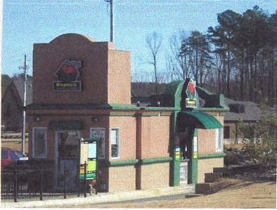
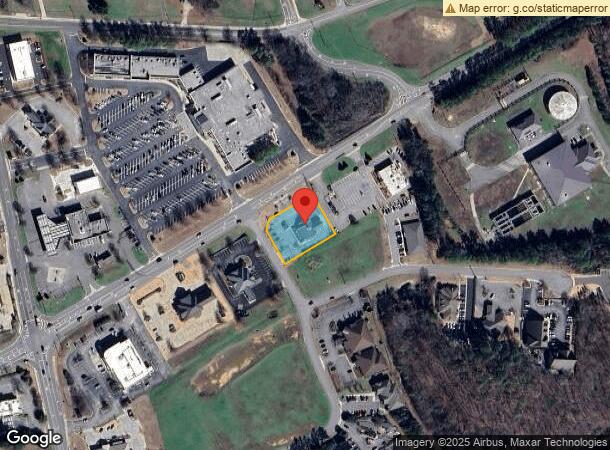
Property Record
1805 New Watermelon Rd, Tuscaloosa, AL 35406
NEARBY LISTINGS FOR SALE OR LEASE
-
-
View all Tuscaloosa listings for sale on LoopNet.com
Property Detail
1805 New Watermelon Rd
Tuscaloosa, AL
The Commons North Ph 2-A
21-09-31-4-003-003.000
LOT 2A THE COMMONS NORTH PH 2-A
Financialbuilding
Tuscaloosa
X
Alabama
01125C0344G
2a
2024
0.65 AC
2024
Tuscaloosa
010405
Birmingham
2,591 SF
DEMOGRAPHICS near 1805 New Watermelon Rd
1 Mile
3 Mile
5 Mile
2024 Total Population
4,055
19,792
94,126
2029 Population
4,610
22,485
105,687
Pop Growth 2024-2029
+ 13.69%
+ 13.61%
+ 12.28%
Average Age
37
39
34
2024 Total Households
1,529
7,694
33,246
HH Growth 2024-2029
+ 13.87%
+ 13.53%
+ 15.05%
Median Household Inc
$117,499
$98,737
$52,510
Avg Household Size
2.60
2.50
2.20
2024 Avg HH Vehicles
2.00
2.00
2.00
Median Home Value
$416,667
$379,965
$269,324
Median Year Built
2002
1994
1992
Nearby Places
- Restaurants
- Banks
- Shops
- Fitness
- Groceries
PUBLIC TRANSPORTATION
COMMUTER RAIL
Tuscaloosa Amtrak Station (Crescent - Amtrak)
DRIVE
WALK
Distance
Tuscaloosa Amtrak Station (Crescent - Amtrak)
14 min
8.0 mi
Freight Ports
Port of Mobile
DRIVE
WALK
Distance
Port of Mobile
250 min
206.7 mi
SALE & LEASE HISTORY
LISTING DATE
SALE/LEASE

Jun 03, 2019
For Sale
Nearby Properties
Address
Land Use
TOTAL SIZE
Lot Size
Zoning
Address
Land Use
TOTAL SIZE
Lot Size
Zoning
22,791 SF
13 AC
Address
Land Use
TOTAL SIZE
Lot Size
Zoning
26,440 SF
14.65 AC
RMF1
Address
Land Use
TOTAL SIZE
Lot Size
Zoning
413,194 SF
7.95 AC
Address
Land Use
TOTAL SIZE
Lot Size
Zoning
45,716 SF
8.80 AC
R4
Address
Land Use
TOTAL SIZE
Lot Size
Zoning
20,185 SF
25.54 AC
Address
Land Use
TOTAL SIZE
Lot Size
Zoning
26,400 SF
51.67 AC
Address
Land Use
TOTAL SIZE
Lot Size
Zoning
3,456 SF
13.98 AC
RM2
Address
Land Use
TOTAL SIZE
Lot Size
Zoning
84,891 SF
3 AC
Address
Land Use
TOTAL SIZE
Lot Size
Zoning
8,120 SF
13 AC
RMF1
Address
Land Use
TOTAL SIZE
Lot Size
Zoning
12,900 SF
47 AC
R1
Address
Land Use
TOTAL SIZE
Lot Size
Zoning
18 AC
BN
Address
Land Use
TOTAL SIZE
Lot Size
Zoning
6,900 SF
8.80 AC
R4
Address
Land Use
TOTAL SIZE
Lot Size
Zoning
24,048 SF
21 AC
Address
Land Use
TOTAL SIZE
Lot Size
Zoning
29,565 SF
11 AC
R1
Address
Land Use
TOTAL SIZE
Lot Size
Zoning
21,962 SF
2.68 AC
BN
Address
Land Use
TOTAL SIZE
Lot Size
Zoning
8,976 SF
7.03 AC
C3
Address
Land Use
TOTAL SIZE
Lot Size
Zoning
39,954 SF
3.39 AC
BN
Address
Land Use
TOTAL SIZE
Lot Size
Zoning
44,716 SF
5.83 AC
BN
Address
Land Use
TOTAL SIZE
Lot Size
Zoning
49,317 SF
3.30 AC
BN
Address
Land Use
TOTAL SIZE
Lot Size
Zoning
65,263 SF
15 AC
I
Address
Land Use
TOTAL SIZE
Lot Size
Zoning
62,575 SF
7.10 AC
C6
Address
Land Use
TOTAL SIZE
Lot Size
Zoning
64,683 SF
6.60 AC
BN
Address
Land Use
TOTAL SIZE
Lot Size
Zoning
18,750 SF
44 SF
Address
Land Use
TOTAL SIZE
Lot Size
Zoning
44,747 SF
5.70 AC
BN
Address
Land Use
TOTAL SIZE
Lot Size
Zoning
13,440 SF
4.48 AC
BN
Address
Land Use
TOTAL SIZE
Lot Size
Zoning
19,575 SF
66 AC
R1
Address
Land Use
TOTAL SIZE
Lot Size
Zoning
45,425 SF
4.15 AC
BGO
Address
Land Use
TOTAL SIZE
Lot Size
Zoning
28,362 SF
11 AC
R3
Address
Land Use
TOTAL SIZE
Lot Size
Zoning
37,772 SF
2.88 AC
BN
Address
Land Use
TOTAL SIZE
Lot Size
Zoning
7.50 AC
The World's #1 Commercial Real Estate Marketplace
Connect with us
© 2025 CoStar Group
The information above has been obtained from sources believed reliable. While we do not doubt its accuracy we have not verified it and make no guarantee, warranty or representation about it. It is your responsibility to independently confirm its accuracy and completeness. Any projections, opinions, assumptions, or estimates used are for example only and do not represent the current or future performance of the property. The value of this transaction to you depends on tax and other factors which should be evaluated by your tax, financial, and legal advisors. You and your advisors should conduct a careful, independent investigation of the property to determine to your satisfaction the suitability of the property for your needs.