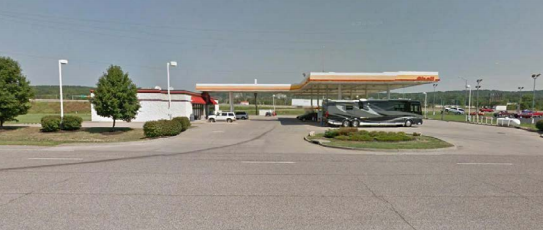
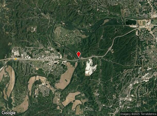
Property Record
18181 Old Us Highway 66, Eureka, MO 63025
NEARBY LISTINGS FOR SALE OR LEASE
Property Detail
18181 Old Us Highway 66
29X-62-0125
SECTION 34 TWN 44 R 3
Servicestation
St. Louis
X
Missouri
29071C0225E
2.28 AC
2024
Outer St Louis County
2024
St. Louis
221421
St. Louis, MO-IL
4,648 SF
DEMOGRAPHICS near 18181 Old Us Highway 66
1 Mile
3 Mile
5 Mile
2024 Total Population
2,185
14,824
28,259
2029 Population
2,211
14,891
28,670
Pop Growth 2024-2029
+ 1.19%
+ 0.45%
+ 1.45%
Average Age
38
39
40
2024 Total Households
626
4,847
9,899
HH Growth 2024-2029
+ 1.76%
+ 0.41%
+ 1.44%
Median Household Inc
$107,291
$127,747
$110,532
Avg Household Size
2.90
2.80
2.70
2024 Avg HH Vehicles
2.00
2.00
2.00
Median Home Value
$336,624
$349,401
$345,587
Median Year Built
1999
1997
1994
Nearby Places
- Restaurants
- Banks
- Shops
- Fitness
- Groceries
PUBLIC TRANSPORTATION
AIRPORT
St Louis Lambert International
DRIVE
WALK
Distance
St Louis Lambert International
40 min
28.4 mi
Freight Ports
Tulsa Port of Inola
DRIVE
WALK
Distance
Tulsa Port of Inola
394 min
359.9 mi
SALE & LEASE HISTORY
LISTING DATE
SALE/LEASE

Sep 24, 2016
For Sale
Dec 08, 2017
For Sale
Apr 03, 2017
For Sale
Nearby Properties
Address
Land Use
TOTAL SIZE
Lot Size
Zoning
Address
Land Use
TOTAL SIZE
Lot Size
Zoning
28,790 SF
1,196.80 AC
NU
Address
Land Use
TOTAL SIZE
Lot Size
Zoning
20,594 SF
1,905.12 AC
NU
Address
Land Use
TOTAL SIZE
Lot Size
Zoning
12,274 SF
86.91 AC
R1
Address
Land Use
TOTAL SIZE
Lot Size
Zoning
207,499 SF
10.11 AC
98R-5
Address
Land Use
TOTAL SIZE
Lot Size
Zoning
39.97 AC
98PI
Address
Land Use
TOTAL SIZE
Lot Size
Zoning
229 AC
FPPS
Address
Land Use
TOTAL SIZE
Lot Size
Zoning
85,759 SF
8.25 AC
H
Address
Land Use
TOTAL SIZE
Lot Size
Zoning
7.48 AC
R4
Address
Land Use
TOTAL SIZE
Lot Size
Zoning
8.30 AC
Address
Land Use
TOTAL SIZE
Lot Size
Zoning
7.50 AC
98R-1
Address
Land Use
TOTAL SIZE
Lot Size
Zoning
48,797 SF
23.28 AC
R1
Address
Land Use
TOTAL SIZE
Lot Size
Zoning
29,960 SF
14.54 AC
NU
Address
Land Use
TOTAL SIZE
Lot Size
Zoning
7.26 AC
R3
Address
Land Use
TOTAL SIZE
Lot Size
Zoning
899 SF
1.41 AC
R3
Address
Land Use
TOTAL SIZE
Lot Size
Zoning
36,184 SF
13.15 AC
98R-5
Address
Land Use
TOTAL SIZE
Lot Size
Zoning
560.41 AC
NU
Address
Land Use
TOTAL SIZE
Lot Size
Zoning
19.10 AC
NU
Address
Land Use
TOTAL SIZE
Lot Size
Zoning
2,870 SF
245 AC
NU
Address
Land Use
TOTAL SIZE
Lot Size
Zoning
27,588 SF
11.07 AC
H
Address
Land Use
TOTAL SIZE
Lot Size
Zoning
26,024 SF
2.65 AC
98PC
Address
Land Use
TOTAL SIZE
Lot Size
Zoning
60,655 SF
2.95 AC
R-5
Address
Land Use
TOTAL SIZE
Lot Size
Zoning
28,200 SF
2.94 AC
98PC
Address
Land Use
TOTAL SIZE
Lot Size
Zoning
9.10 AC
98R-1
Address
Land Use
TOTAL SIZE
Lot Size
Zoning
50,040 SF
3.57 AC
98R-5C
Address
Land Use
TOTAL SIZE
Lot Size
Zoning
8,074 SF
17.04 AC
98M-1
Address
Land Use
TOTAL SIZE
Lot Size
Zoning
21.37 AC
R1
Address
Land Use
TOTAL SIZE
Lot Size
Zoning
14,328 SF
451.70 AC
PI
Address
Land Use
TOTAL SIZE
Lot Size
Zoning
99.75 AC
R1
Address
Land Use
TOTAL SIZE
Lot Size
Zoning
2.29 AC
98PC
Address
Land Use
TOTAL SIZE
Lot Size
Zoning
4,990 SF
2.53 AC
98PC
The World's #1 Commercial Real Estate Marketplace
Connect with us
© 2025 CoStar Group
The information above has been obtained from sources believed reliable. While we do not doubt its accuracy we have not verified it and make no guarantee, warranty or representation about it. It is your responsibility to independently confirm its accuracy and completeness. Any projections, opinions, assumptions, or estimates used are for example only and do not represent the current or future performance of the property. The value of this transaction to you depends on tax and other factors which should be evaluated by your tax, financial, and legal advisors. You and your advisors should conduct a careful, independent investigation of the property to determine to your satisfaction the suitability of the property for your needs.