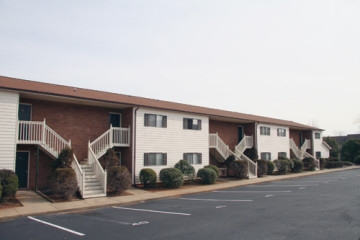
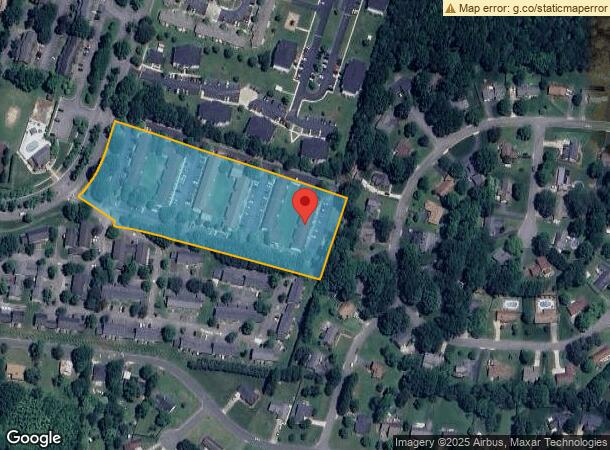
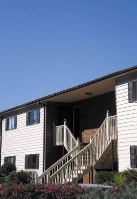
Property Record
1820 20Th Avenue Dr Ne, Hickory, NC 28601

NEARBY LISTINGS FOR SALE OR LEASE
-
-
View all Hickory listings for sale on LoopNet.com
Property Detail
1820 20Th Avenue Dr Ne
3713087779170000
HKY SQ II-CAT RIDGE
Gardenaptcourtapt5plusunits
Catawba
X
North Carolina
3710371300J
5.23 AC
2024
Outer City Of Hickory
2024
Charlotte
010403
Hickory-Lenoir-Morganton, NC
24,064 SF
DEMOGRAPHICS near 1820 20Th Avenue Dr Ne
1 Mile
3 Mile
5 Mile
2024 Total Population
8,250
40,297
73,272
2029 Population
8,690
42,058
76,318
Pop Growth 2024-2029
+ 5.33%
+ 4.37%
+ 4.16%
Average Age
40
41
41
2024 Total Households
3,740
16,790
30,148
HH Growth 2024-2029
+ 5.32%
+ 4.40%
+ 4.14%
Median Household Inc
$46,055
$55,778
$57,008
Avg Household Size
2.20
2.30
2.30
2024 Avg HH Vehicles
2.00
2.00
2.00
Median Home Value
$160,815
$196,610
$199,471
Median Year Built
1984
1979
1981
Nearby Places
- Restaurants
- Banks
- Shops
- Fitness
- Groceries
Nearby Properties
Address
Land Use
TOTAL SIZE
Lot Size
Zoning
Address
Land Use
TOTAL SIZE
Lot Size
Zoning
10,422 SF
4.23 AC
OI
Address
Land Use
TOTAL SIZE
Lot Size
Zoning
8,492 SF
15.83 AC
R-4
Address
Land Use
TOTAL SIZE
Lot Size
Zoning
16,594 SF
7.22 AC
PD
Address
Land Use
TOTAL SIZE
Lot Size
Zoning
19.87 AC
OI
Address
Land Use
TOTAL SIZE
Lot Size
Zoning
7,722 SF
10.01 AC
R-4
Address
Land Use
TOTAL SIZE
Lot Size
Zoning
27.56 AC
OI
Address
Land Use
TOTAL SIZE
Lot Size
Zoning
94,152 SF
14.46 AC
IND
Address
Land Use
TOTAL SIZE
Lot Size
Zoning
17,175 SF
12.17 AC
PD
Address
Land Use
TOTAL SIZE
Lot Size
Zoning
326,813 SF
37.87 AC
IND
Address
Land Use
TOTAL SIZE
Lot Size
Zoning
8,436 SF
13.28 AC
R-4
Address
Land Use
TOTAL SIZE
Lot Size
Zoning
360,779 SF
35.72 AC
IND
Address
Land Use
TOTAL SIZE
Lot Size
Zoning
104,270 SF
0.75 AC
C-1
Address
Land Use
TOTAL SIZE
Lot Size
Zoning
57,658 SF
10.64 AC
OI
Address
Land Use
TOTAL SIZE
Lot Size
Zoning
1,726 SF
15.93 AC
PD
Address
Land Use
TOTAL SIZE
Lot Size
Zoning
8,992 SF
11.66 AC
R-4
Address
Land Use
TOTAL SIZE
Lot Size
Zoning
42.11 AC
R-20
Address
Land Use
TOTAL SIZE
Lot Size
Zoning
8,960 SF
14.07 AC
R-4
Address
Land Use
TOTAL SIZE
Lot Size
Zoning
8,637 SF
5 AC
CC-1
Address
Land Use
TOTAL SIZE
Lot Size
Zoning
14.15 AC
OI
Address
Land Use
TOTAL SIZE
Lot Size
Zoning
22,343 SF
15.54 AC
CC-1
Address
Land Use
TOTAL SIZE
Lot Size
Zoning
60,130 SF
4.02 AC
IND
Address
Land Use
TOTAL SIZE
Lot Size
Zoning
27,426 SF
7.99 AC
PD
Address
Land Use
TOTAL SIZE
Lot Size
Zoning
8.36 AC
OI
Address
Land Use
TOTAL SIZE
Lot Size
Zoning
6,144 SF
11.37 AC
R-4
Address
Land Use
TOTAL SIZE
Lot Size
Zoning
15,164 SF
8.29 AC
PD
Address
Land Use
TOTAL SIZE
Lot Size
Zoning
27,008 SF
12.02 AC
R-3
Address
Land Use
TOTAL SIZE
Lot Size
Zoning
7,742 SF
10.93 AC
PD
Address
Land Use
TOTAL SIZE
Lot Size
Zoning
137,515 SF
12.03 AC
NC
Address
Land Use
TOTAL SIZE
Lot Size
Zoning
22.99 AC
PD
Address
Land Use
TOTAL SIZE
Lot Size
Zoning
44,116 SF
6.33 AC
OI
The World's #1 Commercial Real Estate Marketplace
Connect with us
© 2025 CoStar Group
The information above has been obtained from sources believed reliable. While we do not doubt its accuracy we have not verified it and make no guarantee, warranty or representation about it. It is your responsibility to independently confirm its accuracy and completeness. Any projections, opinions, assumptions, or estimates used are for example only and do not represent the current or future performance of the property. The value of this transaction to you depends on tax and other factors which should be evaluated by your tax, financial, and legal advisors. You and your advisors should conduct a careful, independent investigation of the property to determine to your satisfaction the suitability of the property for your needs.