Property Record
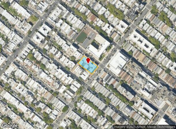
864 49Th St, Brooklyn, NY 11220
NEARBY LISTINGS FOR SALE OR LEASE
Property Detail
864 49Th St
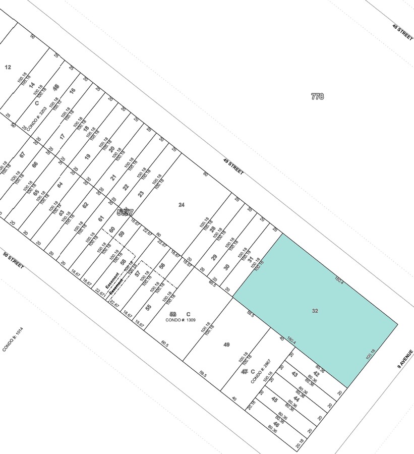
05637-0032
Kings
Multifamilydwelling
New York
X
32
3604970194F
0.41 AC
0
Sunset Park
2024
Long Island (New York)
010802
New York-Jersey City-White Plains, NY-NJ
67,600 SF
DEMOGRAPHICS near 864 49Th St
1 Mile
3 Mile
5 Mile
2024 Total Population
166,135
901,361
2,056,735
2029 Population
150,361
840,416
1,929,224
Pop Growth 2024-2029
(9.49%)
(6.76%)
(6.20%)
Average Age
35
39
39
2024 Total Households
45,860
314,890
759,572
HH Growth 2024-2029
(10.14%)
(7.03%)
(6.49%)
Median Household Inc
$51,938
$72,725
$71,917
Avg Household Size
3.40
2.70
2.60
2024 Avg HH Vehicles
.00
1.00
1.00
Median Home Value
$960,004
$976,335
$835,259
Median Year Built
1947
1947
1948
Nearby Places
- Restaurants
- Banks
- Shops
- Fitness
- Groceries
PUBLIC TRANSPORTATION
TRANSIT/SUBWAY
Fort Hamilton Parkway (D,M Line) (D - New York MTA Subway (The Subway), M - New York MTA Subway (The Subway))
DRIVE
WALK
Distance
Fort Hamilton Parkway (D,M Line) (D - New York MTA Subway (The Subway), M - New York MTA Subway (The Subway))
2 min
9 min
0.5 mi
50 Street (D,M Line) (D - New York MTA Subway (The Subway), M - New York MTA Subway (The Subway))
DRIVE
WALK
Distance
50 Street (D,M Line) (D - New York MTA Subway (The Subway), M - New York MTA Subway (The Subway))
3 min
9 min
0.5 mi
9 Avenue (D - New York MTA Subway (The Subway), M - New York MTA Subway (The Subway))
DRIVE
WALK
Distance
9 Avenue (D - New York MTA Subway (The Subway), M - New York MTA Subway (The Subway))
3 min
11 min
0.6 mi
8 Avenue (N - New York MTA Subway (The Subway))
DRIVE
WALK
Distance
8 Avenue (N - New York MTA Subway (The Subway))
3 min
15 min
0.8 mi
Fort Hamilton Parkway (N Line) (N - New York MTA Subway (The Subway))
DRIVE
WALK
Distance
Fort Hamilton Parkway (N Line) (N - New York MTA Subway (The Subway))
4 min
17 min
0.9 mi
COMMUTER RAIL
Atlantic Terminal (Babylon Branch - Long Island Rail Road, City Terminal Zone - Long Island Rail Road, Hempstead Branch - Long Island Rail Road, West Hempstead Branch - Long Island Rail Road)
DRIVE
WALK
Distance
Atlantic Terminal (Babylon Branch - Long Island Rail Road, City Terminal Zone - Long Island Rail Road, Hempstead Branch - Long Island Rail Road, West Hempstead Branch - Long Island Rail Road)
13 min
4.5 mi
St George (Staten Island Railway - New York MTA Subway (The Subway))
DRIVE
WALK
Distance
St George (Staten Island Railway - New York MTA Subway (The Subway))
22 min
8.8 mi
AIRPORT
John F Kennedy International
DRIVE
WALK
Distance
John F Kennedy International
27 min
14.5 mi
Laguardia
DRIVE
WALK
Distance
Laguardia
29 min
15.1 mi
Newark Liberty International
DRIVE
WALK
Distance
Newark Liberty International
34 min
18.6 mi
Freight Ports
NY - Red Hook Container Terminal
DRIVE
WALK
Distance
NY - Red Hook Container Terminal
10 min
4.0 mi
Nearby Properties
Address
Land Use
TOTAL SIZE
Lot Size
Zoning
Address
Land Use
TOTAL SIZE
Lot Size
Zoning
92,440 SF
466.23 AC
R5
Address
Land Use
TOTAL SIZE
Lot Size
Zoning
393.54 AC
PARK
Address
Land Use
TOTAL SIZE
Lot Size
Zoning
1,545,708 SF
170.96 AC
R4
Address
Land Use
TOTAL SIZE
Lot Size
Zoning
577,381 SF
3.19 AC
R6
Address
Land Use
TOTAL SIZE
Lot Size
Zoning
902,000 SF
6.44 AC
M3-1
Address
Land Use
TOTAL SIZE
Lot Size
Zoning
965,600 SF
6.65 AC
R5
Address
Land Use
TOTAL SIZE
Lot Size
Zoning
460,000 SF
3.21 AC
R6
Address
Land Use
TOTAL SIZE
Lot Size
Zoning
1,073,920 SF
16.53 AC
R6
Address
Land Use
TOTAL SIZE
Lot Size
Zoning
335,800 SF
1.51 AC
R6
Address
Land Use
TOTAL SIZE
Lot Size
Zoning
54.78 AC
PARK
Address
Land Use
TOTAL SIZE
Lot Size
Zoning
785,450 SF
14.22 AC
R6
Address
Land Use
TOTAL SIZE
Lot Size
Zoning
1,324,592 SF
5.13 AC
M3-1
Address
Land Use
TOTAL SIZE
Lot Size
Zoning
397,354 SF
0.61 AC
C5-2
Address
Land Use
TOTAL SIZE
Lot Size
Zoning
566,000 SF
12.33 AC
R6
Address
Land Use
TOTAL SIZE
Lot Size
Zoning
427,208 SF
1.30 AC
R6
Address
Land Use
TOTAL SIZE
Lot Size
Zoning
371,139 SF
3.22 AC
R5
Address
Land Use
TOTAL SIZE
Lot Size
Zoning
744,500 SF
3.22 AC
M3-1
Address
Land Use
TOTAL SIZE
Lot Size
Zoning
286,000 SF
12.63 AC
PARK
Address
Land Use
TOTAL SIZE
Lot Size
Zoning
5,359,400 SF
59.07 AC
M2-1
Address
Land Use
TOTAL SIZE
Lot Size
Zoning
226,429 SF
1.52 AC
R5B
Address
Land Use
TOTAL SIZE
Lot Size
Zoning
1,785,288 SF
22.38 AC
M2-1
Address
Land Use
TOTAL SIZE
Lot Size
Zoning
3,970,000 SF
91.14 AC
M3-1
Address
Land Use
TOTAL SIZE
Lot Size
Zoning
241,735 SF
1.99 AC
C8-4
Address
Land Use
TOTAL SIZE
Lot Size
Zoning
336,534 SF
47.78 AC
M1-1
Address
Land Use
TOTAL SIZE
Lot Size
Zoning
206,640 SF
3.21 AC
R6
Address
Land Use
TOTAL SIZE
Lot Size
Zoning
287,761 SF
1.10 AC
M3-1
Address
Land Use
TOTAL SIZE
Lot Size
Zoning
623,117 SF
4.16 AC
M3-1
Address
Land Use
TOTAL SIZE
Lot Size
Zoning
689,850 SF
3.08 AC
M3-1
Address
Land Use
TOTAL SIZE
Lot Size
Zoning
1,112,855 SF
3.52 AC
M3-1
Address
Land Use
TOTAL SIZE
Lot Size
Zoning
323,193 SF
2.05 AC
M14R72
The World's #1 Commercial Real Estate Marketplace
Connect with us
© 2025 CoStar Group
The information above has been obtained from sources believed reliable. While we do not doubt its accuracy we have not verified it and make no guarantee, warranty or representation about it. It is your responsibility to independently confirm its accuracy and completeness. Any projections, opinions, assumptions, or estimates used are for example only and do not represent the current or future performance of the property. The value of this transaction to you depends on tax and other factors which should be evaluated by your tax, financial, and legal advisors. You and your advisors should conduct a careful, independent investigation of the property to determine to your satisfaction the suitability of the property for your needs.