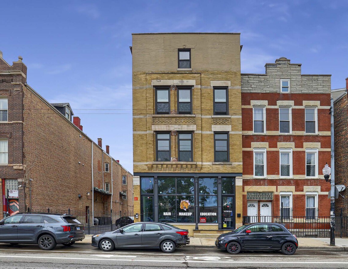
Property Record
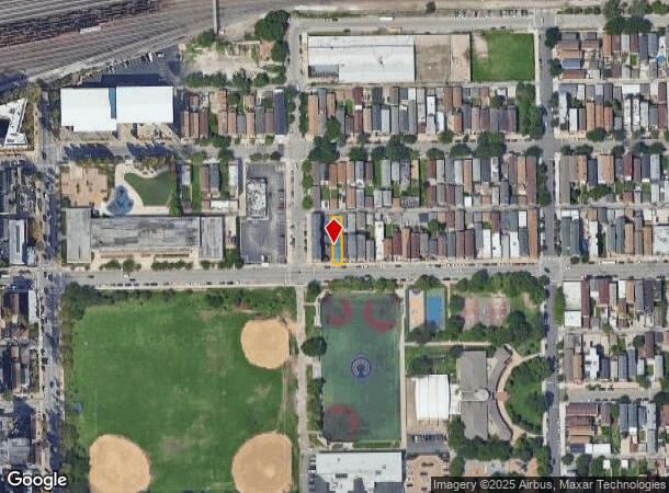
1854 W 18Th St, Chicago, IL 60608

NEARBY LISTINGS FOR SALE OR LEASE
Property Detail
1854 W 18Th St
Chicago-Naperville-Elgin, IL-IN-WI
Newberry Estate
17-19-405-027-0000
(NEWBERRY) (ESTATE) SUB BLK 35 IN DIV OF SEC SEC 19-39-14
Miscresidentialimprovement
Cook
X
Illinois
17031C0506J
78
2022
0.07 AC
2024
Lower West Side
310900
Chicago
4,533 SF
DEMOGRAPHICS near 1854 W 18Th St
1 Mile
3 Mile
5 Mile
2024 Total Population
30,733
374,761
943,469
2029 Population
28,653
357,598
900,448
Pop Growth 2024-2029
(6.77%)
(4.58%)
(4.56%)
Average Age
36
36
37
2024 Total Households
12,630
162,550
411,957
HH Growth 2024-2029
(6.99%)
(4.20%)
(4.02%)
Median Household Inc
$60,388
$78,490
$78,969
Avg Household Size
2.30
2.20
2.20
2024 Avg HH Vehicles
1.00
1.00
1.00
Median Home Value
$308,421
$383,177
$391,253
Median Year Built
1948
1971
1964
Nearby Places
- Restaurants
- Banks
- Shops
- Fitness
- Groceries
PUBLIC TRANSPORTATION
TRANSIT/SUBWAY
18Th Street Station (Pink Line - Chicago Transit Authority "L" Trains (The "L"))
DRIVE
WALK
Distance
18Th Street Station (Pink Line - Chicago Transit Authority "L" Trains (The "L"))
1 min
5 min
0.3 mi
Damen Station (Pink Line) (Pink Line - Chicago Transit Authority "L" Trains (The "L"))
DRIVE
WALK
Distance
Damen Station (Pink Line) (Pink Line - Chicago Transit Authority "L" Trains (The "L"))
1 min
10 min
0.4 mi
Western Station (Pink Line) (Pink Line - Chicago Transit Authority "L" Trains (The "L"))
DRIVE
WALK
Distance
Western Station (Pink Line) (Pink Line - Chicago Transit Authority "L" Trains (The "L"))
2 min
16 min
0.8 mi
COMMUTER RAIL
Western Avenue Station (Bnsf) (Burlington Northern-Santa Fe Railway Line - Northeast Illinois Regional Commuter Railroad (Metra))
DRIVE
WALK
Distance
Western Avenue Station (Bnsf) (Burlington Northern-Santa Fe Railway Line - Northeast Illinois Regional Commuter Railroad (Metra))
1 min
15 min
0.6 mi
Halsted Station (Burlington Northern-Santa Fe Railway Line - Northeast Illinois Regional Commuter Railroad (Metra))
DRIVE
WALK
Distance
Halsted Station (Burlington Northern-Santa Fe Railway Line - Northeast Illinois Regional Commuter Railroad (Metra))
4 min
1.5 mi
AIRPORT
Chicago Midway International
DRIVE
WALK
Distance
Chicago Midway International
13 min
7.6 mi
Chicago O'Hare International
DRIVE
WALK
Distance
Chicago O'Hare International
30 min
18.9 mi
Freight Ports
Port Milwaukee
DRIVE
WALK
Distance
Port Milwaukee
108 min
87.2 mi
SALE & LEASE HISTORY
LISTING DATE
SALE/LEASE

Sep 25, 2024
For Sale
Oct 26, 2020
For Sale
Jun 14, 2022
For Sale
Jun 13, 2024
For Sale
Jun 05, 2017
For Lease
Aug 30, 2023
For Sale
Aug 28, 2020
For Lease
Nearby Properties
Address
Land Use
TOTAL SIZE
Lot Size
Zoning
Address
Land Use
TOTAL SIZE
Lot Size
Zoning
4,667,723 SF
2.94 AC
DC-16
Address
Land Use
TOTAL SIZE
Lot Size
Zoning
1,546,909 SF
0.98 AC
PD 1369
Address
Land Use
TOTAL SIZE
Lot Size
Zoning
1,496,448 SF
2 AC
PD 376
Address
Land Use
TOTAL SIZE
Lot Size
Zoning
1,396,750 SF
4.09 AC
PD 98
Address
Land Use
TOTAL SIZE
Lot Size
Zoning
1,362,475 SF
1.97 AC
PD 1226
Address
Land Use
TOTAL SIZE
Lot Size
Zoning
1,215,367 SF
3.76 AC
PD 675
Address
Land Use
TOTAL SIZE
Lot Size
Zoning
2,429,909 SF
2.93 AC
PD 882
Address
Land Use
TOTAL SIZE
Lot Size
Zoning
4,296,046 SF
6.15 AC
DC-16
Address
Land Use
TOTAL SIZE
Lot Size
Zoning
1,810,145 SF
1.03 AC
PD 365
Address
Land Use
TOTAL SIZE
Lot Size
Zoning
2,750,656 SF
6.29 AC
PD 1065
Address
Land Use
TOTAL SIZE
Lot Size
Zoning
0.82 AC
PD 1115
Address
Land Use
TOTAL SIZE
Lot Size
Zoning
0.88 AC
DC-16,PD 9
Address
Land Use
TOTAL SIZE
Lot Size
Zoning
1,888,207 SF
2.03 AC
PD 264
Address
Land Use
TOTAL SIZE
Lot Size
Zoning
1,600,546 SF
1.04 AC
PD 191
Address
Land Use
TOTAL SIZE
Lot Size
Zoning
1,231,710 SF
2.01 AC
PD 27
Address
Land Use
TOTAL SIZE
Lot Size
Zoning
2.06 AC
DX-16
Address
Land Use
TOTAL SIZE
Lot Size
Zoning
2,456,900 SF
0.96 AC
PD 256
Address
Land Use
TOTAL SIZE
Lot Size
Zoning
2,612,517 SF
1.28 AC
PD 256
Address
Land Use
TOTAL SIZE
Lot Size
Zoning
1.23 AC
PD 291
Address
Land Use
TOTAL SIZE
Lot Size
Zoning
1,502,279 SF
3.79 AC
PD 98
Address
Land Use
TOTAL SIZE
Lot Size
Zoning
1.54 AC
PD 743
Address
Land Use
TOTAL SIZE
Lot Size
Zoning
1,559,966 SF
1.38 AC
DC-12
Address
Land Use
TOTAL SIZE
Lot Size
Zoning
1,571,900 SF
0.59 AC
PD 382
Address
Land Use
TOTAL SIZE
Lot Size
Zoning
959,129 SF
1.32 AC
DC-16
Address
Land Use
TOTAL SIZE
Lot Size
Zoning
1,527,000 SF
1.65 AC
DX-16
Address
Land Use
TOTAL SIZE
Lot Size
Zoning
0.61 AC
PD 824
Address
Land Use
TOTAL SIZE
Lot Size
Zoning
1,661,783 SF
0.56 AC
PD 500
Address
Land Use
TOTAL SIZE
Lot Size
Zoning
775,852 SF
1.72 AC
PD 27
Address
Land Use
TOTAL SIZE
Lot Size
Zoning
775,852 SF
1.76 AC
PD 27
Address
Land Use
TOTAL SIZE
Lot Size
Zoning
1,250,000 SF
1.51 AC
PD 27
The World's #1 Commercial Real Estate Marketplace
Connect with us
© 2025 CoStar Group
The information above has been obtained from sources believed reliable. While we do not doubt its accuracy we have not verified it and make no guarantee, warranty or representation about it. It is your responsibility to independently confirm its accuracy and completeness. Any projections, opinions, assumptions, or estimates used are for example only and do not represent the current or future performance of the property. The value of this transaction to you depends on tax and other factors which should be evaluated by your tax, financial, and legal advisors. You and your advisors should conduct a careful, independent investigation of the property to determine to your satisfaction the suitability of the property for your needs.