Property Record
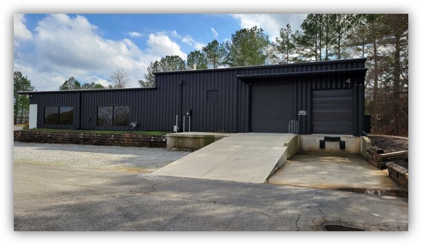
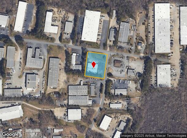
1855 Mcfarland 400 Dr, Alpharetta, GA 30004

NEARBY LISTINGS FOR SALE OR LEASE
Property Detail
1855 Mcfarland 400 Dr
Atlanta-Sandy Springs-Roswell, GA
Mcfarland 400 Industrial Park Phase Ii
063-003
2-1 748 MCFARLAND 400 IND PARK TR 7
Industrialgeneral
Forsyth
X
Georgia
13117C0138F
7
2023
1.10 AC
2024
N Fulton/Forsyth Cnty
130603
Atlanta
3,850 SF
DEMOGRAPHICS near 1855 Mcfarland 400 Dr
1 Mile
3 Mile
5 Mile
2024 Total Population
3,578
57,240
157,327
2029 Population
4,123
64,555
173,471
Pop Growth 2024-2029
+ 15.23%
+ 12.78%
+ 10.26%
Average Age
35
37
38
2024 Total Households
1,154
20,025
53,434
HH Growth 2024-2029
+ 15.25%
+ 12.57%
+ 10.08%
Median Household Inc
$126,786
$120,163
$136,176
Avg Household Size
3.00
2.80
2.90
2024 Avg HH Vehicles
2.00
2.00
2.00
Median Home Value
$411,884
$467,109
$479,677
Median Year Built
2010
2005
2000
Nearby Places
- Restaurants
- Banks
- Shops
- Fitness
- Groceries
SALE & LEASE HISTORY
LISTING DATE
SALE/LEASE

Sep 23, 2024
For Sale
Mar 05, 2024
For Sale
Jul 10, 2020
For Sale
Jan 15, 2018
For Sale
Nearby Properties
Address
Land Use
TOTAL SIZE
Lot Size
Zoning
Address
Land Use
TOTAL SIZE
Lot Size
Zoning
574,271 SF
45.82 AC
AC
Address
Land Use
TOTAL SIZE
Lot Size
Zoning
461,754 SF
28.07 AC
C1C
Address
Land Use
TOTAL SIZE
Lot Size
Zoning
645,668 SF
30.05 AC
AC
Address
Land Use
TOTAL SIZE
Lot Size
Zoning
332,608 SF
32.63 AC
CUP
Address
Land Use
TOTAL SIZE
Lot Size
Zoning
328,265 SF
4 AC
MP
Address
Land Use
TOTAL SIZE
Lot Size
Zoning
167,705 SF
14.46 AC
CUP
Address
Land Use
TOTAL SIZE
Lot Size
Zoning
309,293 SF
16 AC
CBD
Address
Land Use
TOTAL SIZE
Lot Size
Zoning
383,859 SF
9.05 AC
CBD
Address
Land Use
TOTAL SIZE
Lot Size
Zoning
56,313 SF
13.37 AC
MP
Address
Land Use
TOTAL SIZE
Lot Size
Zoning
281,780 SF
19.14 AC
PUD
Address
Land Use
TOTAL SIZE
Lot Size
Zoning
2.12 AC
MP
Address
Land Use
TOTAL SIZE
Lot Size
Zoning
90,671 SF
11.03 AC
MP
Address
Land Use
TOTAL SIZE
Lot Size
Zoning
311,452 SF
29.19 AC
CUP
Address
Land Use
TOTAL SIZE
Lot Size
Zoning
10,908 SF
107.57 AC
RES3
Address
Land Use
TOTAL SIZE
Lot Size
Zoning
504,893 SF
17.14 AC
CUP
Address
Land Use
TOTAL SIZE
Lot Size
Zoning
186,907 SF
13.93 AC
A0
Address
Land Use
TOTAL SIZE
Lot Size
Zoning
182,039 SF
19.40 AC
CUP
Address
Land Use
TOTAL SIZE
Lot Size
Zoning
119,926 SF
23.23 AC
M1
Address
Land Use
TOTAL SIZE
Lot Size
Zoning
83,161 SF
277.43 AC
A1
Address
Land Use
TOTAL SIZE
Lot Size
Zoning
141,728 SF
32.45 AC
M1
Address
Land Use
TOTAL SIZE
Lot Size
Zoning
255,201 SF
19.87 AC
CUP
Address
Land Use
TOTAL SIZE
Lot Size
Zoning
4,616 SF
12.32 AC
R3
Address
Land Use
TOTAL SIZE
Lot Size
Zoning
206,400 SF
7.26 AC
CUP
Address
Land Use
TOTAL SIZE
Lot Size
Zoning
232,832 SF
17.74 AC
M1
Address
Land Use
TOTAL SIZE
Lot Size
Zoning
192,316 SF
51.53 AC
A1
Address
Land Use
TOTAL SIZE
Lot Size
Zoning
70,832 SF
113.56 AC
CUP
Address
Land Use
TOTAL SIZE
Lot Size
Zoning
16.56 AC
MP
Address
Land Use
TOTAL SIZE
Lot Size
Zoning
116,640 SF
6.92 AC
MP
Address
Land Use
TOTAL SIZE
Lot Size
Zoning
122,964 SF
7.82 AC
RES6
Address
Land Use
TOTAL SIZE
Lot Size
Zoning
194,460 SF
40.89 AC
CUP
The World's #1 Commercial Real Estate Marketplace
Connect with us
© 2025 CoStar Group
The information above has been obtained from sources believed reliable. While we do not doubt its accuracy we have not verified it and make no guarantee, warranty or representation about it. It is your responsibility to independently confirm its accuracy and completeness. Any projections, opinions, assumptions, or estimates used are for example only and do not represent the current or future performance of the property. The value of this transaction to you depends on tax and other factors which should be evaluated by your tax, financial, and legal advisors. You and your advisors should conduct a careful, independent investigation of the property to determine to your satisfaction the suitability of the property for your needs.