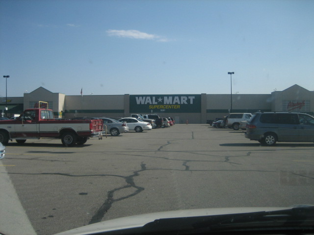
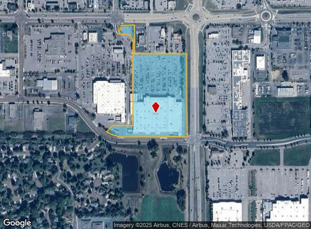
Property Record
1881 Madison Ave, Mankato, MN 56001
NEARBY LISTINGS FOR SALE OR LEASE
Property Detail
1881 Madison Ave
Other Market Areas
Hilltop Power Center No 2
Mankato-North Mankato, MN
HILLTOP POWER CENTER NO 2 003 001 00
R01-09-16-226-025
Blue Earth
Storebuilding
Minnesota
2023
3
2023
13.77 AC
170500
East Mankato
206,288 SF
DEMOGRAPHICS near 1881 Madison Ave
1 Mile
3 Mile
5 Mile
2024 Total Population
5,941
40,258
63,522
2029 Population
6,133
41,275
64,782
Pop Growth 2024-2029
+ 3.23%
+ 2.53%
+ 1.98%
Average Age
39
35
36
2024 Total Households
2,609
16,535
25,249
HH Growth 2024-2029
+ 3.33%
+ 2.63%
+ 2.10%
Median Household Inc
$71,666
$60,573
$66,045
Avg Household Size
2.20
2.20
2.30
2024 Avg HH Vehicles
2.00
2.00
2.00
Median Home Value
$267,107
$216,838
$222,595
Median Year Built
1995
1985
1981
Nearby Places
- Restaurants
- Banks
- Shops
- Fitness
- Groceries
Nearby Properties
Address
Land Use
TOTAL SIZE
Lot Size
Zoning
Address
Land Use
TOTAL SIZE
Lot Size
Zoning
4,896 SF
6.31 AC
Address
Land Use
TOTAL SIZE
Lot Size
Zoning
147,416 SF
79.30 AC
Address
Land Use
TOTAL SIZE
Lot Size
Zoning
7,920 SF
4.06 AC
Address
Land Use
TOTAL SIZE
Lot Size
Zoning
178,201 SF
64.49 AC
Address
Land Use
TOTAL SIZE
Lot Size
Zoning
191,916 SF
37.68 AC
Address
Land Use
TOTAL SIZE
Lot Size
Zoning
12.37 AC
Address
Land Use
TOTAL SIZE
Lot Size
Zoning
17.90 AC
Address
Land Use
TOTAL SIZE
Lot Size
Zoning
13.43 AC
Address
Land Use
TOTAL SIZE
Lot Size
Zoning
431,029 SF
31.57 AC
Address
Land Use
TOTAL SIZE
Lot Size
Zoning
4,800 SF
138.79 AC
Address
Land Use
TOTAL SIZE
Lot Size
Zoning
11.75 AC
Address
Land Use
TOTAL SIZE
Lot Size
Zoning
287,085 SF
38 AC
Address
Land Use
TOTAL SIZE
Lot Size
Zoning
329,820 SF
18.94 AC
Address
Land Use
TOTAL SIZE
Lot Size
Zoning
101,602 SF
20 AC
Address
Land Use
TOTAL SIZE
Lot Size
Zoning
331,604 SF
35.88 AC
Address
Land Use
TOTAL SIZE
Lot Size
Zoning
47,274 SF
17.47 AC
Address
Land Use
TOTAL SIZE
Lot Size
Zoning
157,216 SF
31.67 AC
Address
Land Use
TOTAL SIZE
Lot Size
Zoning
4.26 AC
Address
Land Use
TOTAL SIZE
Lot Size
Zoning
137,968 SF
11.96 AC
Address
Land Use
TOTAL SIZE
Lot Size
Zoning
3.73 AC
Address
Land Use
TOTAL SIZE
Lot Size
Zoning
133,550 SF
5.71 AC
Address
Land Use
TOTAL SIZE
Lot Size
Zoning
116,561 SF
3.87 AC
Address
Land Use
TOTAL SIZE
Lot Size
Zoning
91,204 SF
44.54 AC
Address
Land Use
TOTAL SIZE
Lot Size
Zoning
63,880 SF
9.19 AC
Address
Land Use
TOTAL SIZE
Lot Size
Zoning
6.91 AC
Address
Land Use
TOTAL SIZE
Lot Size
Zoning
6.44 AC
Address
Land Use
TOTAL SIZE
Lot Size
Zoning
31,026 SF
1.19 AC
Address
Land Use
TOTAL SIZE
Lot Size
Zoning
0.75 AC
The World's #1 Commercial Real Estate Marketplace
Connect with us
© 2025 CoStar Group
The information above has been obtained from sources believed reliable. While we do not doubt its accuracy we have not verified it and make no guarantee, warranty or representation about it. It is your responsibility to independently confirm its accuracy and completeness. Any projections, opinions, assumptions, or estimates used are for example only and do not represent the current or future performance of the property. The value of this transaction to you depends on tax and other factors which should be evaluated by your tax, financial, and legal advisors. You and your advisors should conduct a careful, independent investigation of the property to determine to your satisfaction the suitability of the property for your needs.