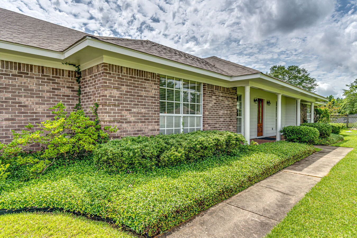
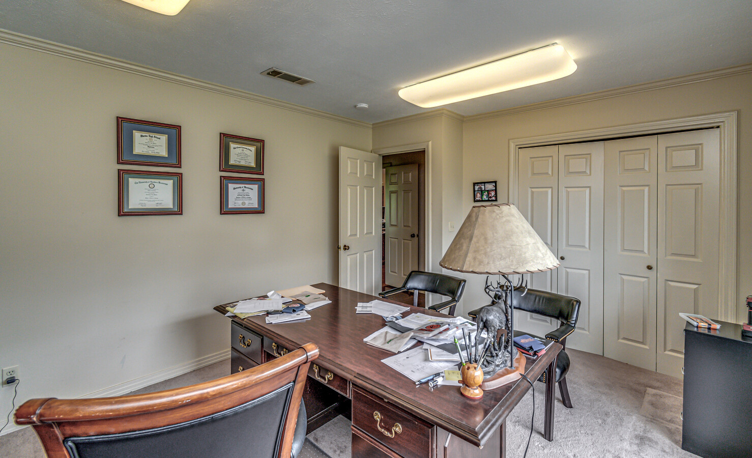
Property Record
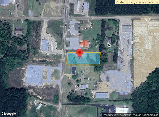
1896 Highway 471, Brandon, MS 39047
NEARBY LISTINGS FOR SALE OR LEASE
-
-
View all Brandon listings for sale on LoopNet.com
Property Detail
1896 Highway 471
I11-000056-00020
Ne4ne4s22t6nr3e
Professionalbldglegalinsurancerealestateetc
1.42 AC NE4 NE4 E OF HWY 471 DB 592 PG 0246 0011290 DB 721 PG 0687 0011795 DB 583 PG 0347 0082489
X
Rankin
28121C0205F
Mississippi
2024
1.42 AC
2024
Outlying Rankin County
020103
Jackson
2,511 SF
Jackson, MS
DEMOGRAPHICS near 1896 Highway 471
1 Mile
3 Mile
5 Mile
2024 Total Population
1,151
17,441
48,831
2029 Population
1,186
17,872
50,319
Pop Growth 2024-2029
+ 3.04%
+ 2.47%
+ 3.05%
Average Age
40
41
41
2024 Total Households
450
6,645
19,015
HH Growth 2024-2029
+ 3.33%
+ 2.56%
+ 3.12%
Median Household Inc
$119,033
$108,181
$97,338
Avg Household Size
2.50
2.60
2.50
2024 Avg HH Vehicles
3.00
2.00
2.00
Median Home Value
$287,217
$266,715
$259,415
Median Year Built
1998
1995
1997
Nearby Places
- Restaurants
- Banks
- Shops
- Fitness
- Groceries
PUBLIC TRANSPORTATION
AIRPORT
Jackson-Medgar Wiley Evers International
DRIVE
WALK
Distance
Jackson-Medgar Wiley Evers International
24 min
12.9 mi
Freight Ports
Port of Gulf Port
DRIVE
WALK
Distance
Port of Gulf Port
211 min
163.0 mi
SALE & LEASE HISTORY
LISTING DATE
SALE/LEASE

Jun 28, 2021
For Sale
Jun 03, 2019
For Sale
Nearby Properties
Address
Land Use
TOTAL SIZE
Lot Size
Zoning
Address
Land Use
TOTAL SIZE
Lot Size
Zoning
4,902 SF
31.76 AC
Address
Land Use
TOTAL SIZE
Lot Size
Zoning
8,030 SF
222.20 AC
Address
Land Use
TOTAL SIZE
Lot Size
Zoning
50.99 AC
Address
Land Use
TOTAL SIZE
Lot Size
Zoning
6,163 SF
5.09 AC
Address
Land Use
TOTAL SIZE
Lot Size
Zoning
9,036 SF
8.68 AC
Address
Land Use
TOTAL SIZE
Lot Size
Zoning
11,284 SF
7.60 AC
Address
Land Use
TOTAL SIZE
Lot Size
Zoning
47,009 SF
6.85 AC
Address
Land Use
TOTAL SIZE
Lot Size
Zoning
78,049 SF
5.44 AC
Address
Land Use
TOTAL SIZE
Lot Size
Zoning
76,236 SF
8.05 AC
Address
Land Use
TOTAL SIZE
Lot Size
Zoning
55,380 SF
7.79 AC
Address
Land Use
TOTAL SIZE
Lot Size
Zoning
56,249 SF
5.28 AC
Address
Land Use
TOTAL SIZE
Lot Size
Zoning
82,391 SF
2.68 AC
Address
Land Use
TOTAL SIZE
Lot Size
Zoning
1.80 AC
Address
Land Use
TOTAL SIZE
Lot Size
Zoning
3,681 SF
2.20 AC
Address
Land Use
TOTAL SIZE
Lot Size
Zoning
8.05 AC
Address
Land Use
TOTAL SIZE
Lot Size
Zoning
18,907 SF
3.03 AC
Address
Land Use
TOTAL SIZE
Lot Size
Zoning
28,978 SF
3.84 AC
Address
Land Use
TOTAL SIZE
Lot Size
Zoning
19,959 SF
2.30 AC
Address
Land Use
TOTAL SIZE
Lot Size
Zoning
8,258 SF
428 AC
Address
Land Use
TOTAL SIZE
Lot Size
Zoning
7.10 AC
Address
Land Use
TOTAL SIZE
Lot Size
Zoning
Address
Land Use
TOTAL SIZE
Lot Size
Zoning
8,537 SF
1.69 AC
Address
Land Use
TOTAL SIZE
Lot Size
Zoning
1,601 SF
7.62 AC
Address
Land Use
TOTAL SIZE
Lot Size
Zoning
6,954 SF
1.50 AC
Address
Land Use
TOTAL SIZE
Lot Size
Zoning
3,383 SF
1.50 AC
Address
Land Use
TOTAL SIZE
Lot Size
Zoning
1,200 SF
3.86 AC
Address
Land Use
TOTAL SIZE
Lot Size
Zoning
3,900 SF
320.40 AC
Address
Land Use
TOTAL SIZE
Lot Size
Zoning
23,958 SF
5.06 AC
Address
Land Use
TOTAL SIZE
Lot Size
Zoning
6,563 SF
1.28 AC
Address
Land Use
TOTAL SIZE
Lot Size
Zoning
5,465 SF
1.96 AC
The World's #1 Commercial Real Estate Marketplace
Connect with us
© 2025 CoStar Group
The information above has been obtained from sources believed reliable. While we do not doubt its accuracy we have not verified it and make no guarantee, warranty or representation about it. It is your responsibility to independently confirm its accuracy and completeness. Any projections, opinions, assumptions, or estimates used are for example only and do not represent the current or future performance of the property. The value of this transaction to you depends on tax and other factors which should be evaluated by your tax, financial, and legal advisors. You and your advisors should conduct a careful, independent investigation of the property to determine to your satisfaction the suitability of the property for your needs.