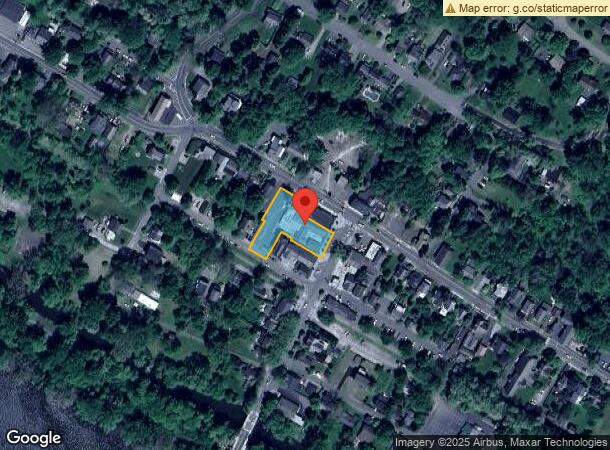
Property Record
19 S Bridge St, Milford, NJ 08848
NEARBY LISTINGS FOR SALE OR LEASE
-
-
View all Milford listings for sale on LoopNet.com
Property Detail
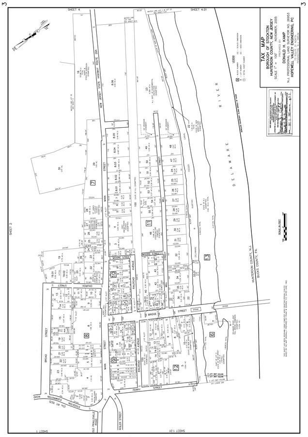
19 S Bridge St
23-00009-0000-00009
INCL BLK 9 LOTS 11 & 9
Storebuilding
Hunterdon
AE
New Jersey
42017C0213J
9
2023
0.58 AC
2024
Hunterdon
010600
Northern New Jersey
5,262 SF
Newark, NJ-PA
DEMOGRAPHICS near 19 S Bridge St
1 Mile
3 Mile
5 Mile
2024 Total Population
768
6,889
21,177
2029 Population
769
6,835
21,104
Pop Growth 2024-2029
+ 0.13%
(0.78%)
(0.34%)
Average Age
49
48
48
2024 Total Households
342
2,968
9,209
HH Growth 2024-2029
+ 0.29%
(0.67%)
(0.23%)
Median Household Inc
$126,179
$132,153
$132,745
Avg Household Size
2.20
2.30
2.30
2024 Avg HH Vehicles
2.00
2.00
2.00
Median Home Value
$446,875
$647,777
$643,615
Median Year Built
1959
1968
1974
Nearby Places
- Restaurants
- Banks
- Shops
- Fitness
- Groceries
PUBLIC TRANSPORTATION
AIRPORT
Trenton Mercer
DRIVE
WALK
Distance
Trenton Mercer
28 min
16.6 mi
Lehigh Valley International
DRIVE
WALK
Distance
Lehigh Valley International
70 min
38.8 mi
Freight Ports
Port of Philadelphia
DRIVE
WALK
Distance
Port of Philadelphia
58 min
33.7 mi
Nearby Properties
Address
Land Use
TOTAL SIZE
Lot Size
Zoning
Address
Land Use
TOTAL SIZE
Lot Size
Zoning
10,746 SF
1.68 AC
FP
Address
Land Use
TOTAL SIZE
Lot Size
Zoning
14,429 SF
2.20 AC
COM
Address
Land Use
TOTAL SIZE
Lot Size
Zoning
39,390 SF
1.80 AC
R-2
Address
Land Use
TOTAL SIZE
Lot Size
Zoning
100 AC
I-2
Address
Land Use
TOTAL SIZE
Lot Size
Zoning
8,456 SF
2.36 AC
R-2
Address
Land Use
TOTAL SIZE
Lot Size
Zoning
11,452 SF
3.95 AC
PRD
Address
Land Use
TOTAL SIZE
Lot Size
Zoning
12,978 SF
2.37 AC
A-1
Address
Land Use
TOTAL SIZE
Lot Size
Zoning
6,851 SF
8.55 AC
RL
Address
Land Use
TOTAL SIZE
Lot Size
Zoning
8,340 SF
1 AC
A-1
Address
Land Use
TOTAL SIZE
Lot Size
Zoning
12,391 SF
1 AC
A-1
Address
Land Use
TOTAL SIZE
Lot Size
Zoning
4,510 SF
9.27 AC
R140
Address
Land Use
TOTAL SIZE
Lot Size
Zoning
3,403 SF
1.95 AC
COM
Address
Land Use
TOTAL SIZE
Lot Size
Zoning
10,371 SF
0.28 AC
R-2
Address
Land Use
TOTAL SIZE
Lot Size
Zoning
13,119 SF
6 AC
A-1
Address
Land Use
TOTAL SIZE
Lot Size
Zoning
14,645 SF
0.66 AC
COM
Address
Land Use
TOTAL SIZE
Lot Size
Zoning
158.87 AC
A-1
Address
Land Use
TOTAL SIZE
Lot Size
Zoning
4,494 SF
0.42 AC
R-2
Address
Land Use
TOTAL SIZE
Lot Size
Zoning
4,964 SF
0.36 AC
R-2
Address
Land Use
TOTAL SIZE
Lot Size
Zoning
9,942 SF
1.66 AC
CR
Address
Land Use
TOTAL SIZE
Lot Size
Zoning
5,396 SF
1 AC
A-1
Address
Land Use
TOTAL SIZE
Lot Size
Zoning
6,881 SF
0.47 AC
R-2
Address
Land Use
TOTAL SIZE
Lot Size
Zoning
141.26 AC
A-2
Address
Land Use
TOTAL SIZE
Lot Size
Zoning
8,749 SF
9.60 AC
A-1
Address
Land Use
TOTAL SIZE
Lot Size
Zoning
9,930 SF
0.63 AC
R110
Address
Land Use
TOTAL SIZE
Lot Size
Zoning
1,560 SF
3.15 AC
PL
Address
Land Use
TOTAL SIZE
Lot Size
Zoning
7,590 SF
1 AC
A-1
Address
Land Use
TOTAL SIZE
Lot Size
Zoning
8,035 SF
2.09 AC
PRD
Address
Land Use
TOTAL SIZE
Lot Size
Zoning
18,120 SF
1.20 AC
COM
Address
Land Use
TOTAL SIZE
Lot Size
Zoning
4,882 SF
4 AC
A-2
The World's #1 Commercial Real Estate Marketplace
Connect with us
© 2025 CoStar Group
The information above has been obtained from sources believed reliable. While we do not doubt its accuracy we have not verified it and make no guarantee, warranty or representation about it. It is your responsibility to independently confirm its accuracy and completeness. Any projections, opinions, assumptions, or estimates used are for example only and do not represent the current or future performance of the property. The value of this transaction to you depends on tax and other factors which should be evaluated by your tax, financial, and legal advisors. You and your advisors should conduct a careful, independent investigation of the property to determine to your satisfaction the suitability of the property for your needs.