Property Record
1901 Paul Walsh Dr, Macon, GA 31206
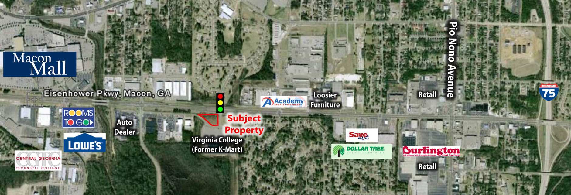

This Property Is For Sale
NEARBY LISTINGS FOR SALE OR LEASE
Property Detail
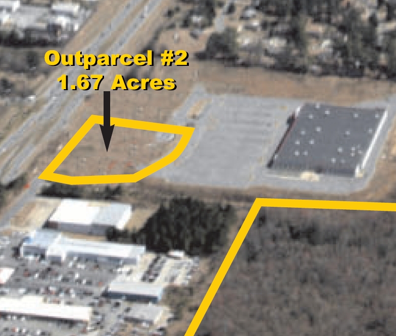
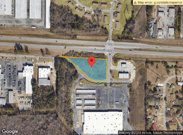
1901 Paul Walsh Dr
Macon-Bibb County, GA
Jdn Dev Co Inc
N092-0014
Bibb
Commercialacreage
Georgia
A
156&157
13021C0133G
1.67 AC
2024
Suburban Macon
2024
Atlanta
012600
DEMOGRAPHICS near 1901 Paul Walsh Dr
1 Mile
3 Mile
5 Mile
2024 Total Population
4,658
58,932
88,605
2029 Population
4,607
59,045
88,640
Pop Growth 2024-2029
(1.09%)
+ 0.19%
+ 0.04%
Average Age
39
37
37
2024 Total Households
1,826
22,775
35,430
HH Growth 2024-2029
(0.93%)
+ 0.35%
+ 0.06%
Median Household Inc
$35,993
$31,065
$38,089
Avg Household Size
2.40
2.40
2.30
2024 Avg HH Vehicles
1.00
1.00
1.00
Median Home Value
$77,213
$80,506
$120,767
Median Year Built
1962
1964
1967
Nearby Places
- Restaurants
- Banks
- Shops
- Fitness
- Groceries
Nearby Properties
Address
Land Use
TOTAL SIZE
Lot Size
Zoning
Address
Land Use
TOTAL SIZE
Lot Size
Zoning
55,368 SF
9.53 AC
CBD-2
Address
Land Use
TOTAL SIZE
Lot Size
Zoning
63,394 SF
5.30 AC
M-1/R-3
Address
Land Use
TOTAL SIZE
Lot Size
Zoning
100,599 SF
0.43 AC
CBD-1
Address
Land Use
TOTAL SIZE
Lot Size
Zoning
158,480 SF
0.90 AC
CBD-2
Address
Land Use
TOTAL SIZE
Lot Size
Zoning
127,536 SF
3.56 AC
PDE
Address
Land Use
TOTAL SIZE
Lot Size
Zoning
181,396 SF
44.77 AC
R-1A
Address
Land Use
TOTAL SIZE
Lot Size
Zoning
12,817 SF
357.49 AC
M-2
Address
Land Use
TOTAL SIZE
Lot Size
Zoning
199,096 SF
22.03 AC
R-2
Address
Land Use
TOTAL SIZE
Lot Size
Zoning
1,428 SF
64.46 AC
R-1A
Address
Land Use
TOTAL SIZE
Lot Size
Zoning
204,144 SF
95 AC
M-2
Address
Land Use
TOTAL SIZE
Lot Size
Zoning
92,712 SF
2.93 AC
CBD-2
Address
Land Use
TOTAL SIZE
Lot Size
Zoning
89,814 SF
16.60 AC
R-1A
Address
Land Use
TOTAL SIZE
Lot Size
Zoning
98,928 SF
12.32 AC
R-3
Address
Land Use
TOTAL SIZE
Lot Size
Zoning
85,556 SF
10.50 AC
R-1A
Address
Land Use
TOTAL SIZE
Lot Size
Zoning
110,153 SF
22 AC
R-2
Address
Land Use
TOTAL SIZE
Lot Size
Zoning
3,268 SF
9.29 AC
R-3
Address
Land Use
TOTAL SIZE
Lot Size
Zoning
46,288 SF
1.80 AC
PDE
Address
Land Use
TOTAL SIZE
Lot Size
Zoning
33,248 SF
10.18 AC
R-3
Address
Land Use
TOTAL SIZE
Lot Size
Zoning
202,057 SF
33.05 AC
C-4
Address
Land Use
TOTAL SIZE
Lot Size
Zoning
40,560 SF
19.20 AC
R-2
Address
Land Use
TOTAL SIZE
Lot Size
Zoning
105,296 SF
18.25 AC
C-2
Address
Land Use
TOTAL SIZE
Lot Size
Zoning
119,564 SF
3.89 AC
R-3
Address
Land Use
TOTAL SIZE
Lot Size
Zoning
96,512 SF
11.30 AC
PDE
Address
Land Use
TOTAL SIZE
Lot Size
Zoning
3,860 SF
22 AC
PDE
Address
Land Use
TOTAL SIZE
Lot Size
Zoning
82,064 SF
12.67 AC
C-2
Address
Land Use
TOTAL SIZE
Lot Size
Zoning
72,073 SF
0.96 AC
CBD-1
Address
Land Use
TOTAL SIZE
Lot Size
Zoning
6,560 SF
17 AC
PDE
Address
Land Use
TOTAL SIZE
Lot Size
Zoning
133,862 SF
25.44 AC
C-2
Address
Land Use
TOTAL SIZE
Lot Size
Zoning
72,048 SF
2.84 AC
R-2
Address
Land Use
TOTAL SIZE
Lot Size
Zoning
8,480 SF
7.92 AC
HPD-BH
The World's #1 Commercial Real Estate Marketplace
Connect with us
© 2025 CoStar Group
The information above has been obtained from sources believed reliable. While we do not doubt its accuracy we have not verified it and make no guarantee, warranty or representation about it. It is your responsibility to independently confirm its accuracy and completeness. Any projections, opinions, assumptions, or estimates used are for example only and do not represent the current or future performance of the property. The value of this transaction to you depends on tax and other factors which should be evaluated by your tax, financial, and legal advisors. You and your advisors should conduct a careful, independent investigation of the property to determine to your satisfaction the suitability of the property for your needs.