Property Record
1905 S Carrollton Ave, New Orleans, LA 70118


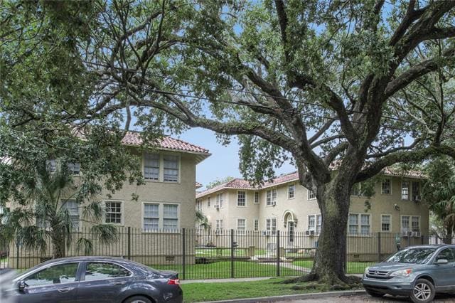
This Property Is For Sale
NEARBY LISTINGS FOR SALE OR LEASE
Property Detail
1905 S Carrollton Ave
New Orleans-Metairie, LA
Dading Marques & Assocs Inc
7-16-3-020-01
SQ 255 LOTS 20-22 PTS 19,23 S CARROLLTON & COHN 100 X 120
Apartment
Orleans
X
Louisiana
22051C0225F
20
2025
0.28 AC
2025
East Carrollton
012700
New Orleans/Metairie/Kenner
12,540 SF
DEMOGRAPHICS near 1905 S Carrollton Ave
1 Mile
3 Mile
5 Mile
2024 Total Population
27,469
144,644
349,015
2029 Population
26,375
140,041
338,296
Pop Growth 2024-2029
(3.98%)
(3.18%)
(3.07%)
Average Age
37
41
42
2024 Total Households
10,312
64,989
160,832
HH Growth 2024-2029
(4.72%)
(3.35%)
(3.09%)
Median Household Inc
$62,143
$59,278
$55,570
Avg Household Size
2.10
2.00
2.10
2024 Avg HH Vehicles
1.00
1.00
1.00
Median Home Value
$390,018
$400,806
$324,204
Median Year Built
1946
1948
1957
Nearby Places
Map Layers
Map Styles
 Street
 Aerial
- Restaurants
- Banks
- Shops
- Fitness
- Groceries
PUBLIC TRANSPORTATION
TRANSIT/SUBWAY
Carrollton And Spruce (St. Charles Streetcar - New Orleans Regional Transit Authority Streetcars (New Orleans Streetcars))
DRIVE
WALK
Distance
Carrollton And Spruce (St. Charles Streetcar - New Orleans Regional Transit Authority Streetcars (New Orleans Streetcars))
0 min
0 min
0.0 mi
Carrollton And Hickory (St. Charles Streetcar - New Orleans Regional Transit Authority Streetcars (New Orleans Streetcars))
DRIVE
WALK
Distance
Carrollton And Hickory (St. Charles Streetcar - New Orleans Regional Transit Authority Streetcars (New Orleans Streetcars))
0 min
1 min
0.1 mi
Carrollton And Sycamore (St. Charles Streetcar - NORTA)
DRIVE
WALK
Distance
Carrollton And Sycamore (St. Charles Streetcar - NORTA)
0 min
3 min
0.2 mi
Carrollton And Birch (St. Charles Streetcar - New Orleans Regional Transit Authority Streetcars (New Orleans Streetcars))
DRIVE
WALK
Distance
Carrollton And Birch (St. Charles Streetcar - New Orleans Regional Transit Authority Streetcars (New Orleans Streetcars))
1 min
4 min
0.2 mi
Carrollton And Claiborne (St. Charles Streetcar - New Orleans Regional Transit Authority Streetcars (New Orleans Streetcars))
DRIVE
WALK
Distance
Carrollton And Claiborne (St. Charles Streetcar - New Orleans Regional Transit Authority Streetcars (New Orleans Streetcars))
0 min
5 min
0.3 mi
COMMUTER RAIL
New Orleans Union Passenger Terminal (City of New Orleans - Amtrak, Crescent - Amtrak, Sunset Limited - Amtrak)
DRIVE
WALK
Distance
New Orleans Union Passenger Terminal (City of New Orleans - Amtrak, Crescent - Amtrak, Sunset Limited - Amtrak)
8 min
4.1 mi
AIRPORT
Louis Armstrong New Orleans International
DRIVE
WALK
Distance
Louis Armstrong New Orleans International
21 min
13.8 mi
Freight Ports
Port of New Orleans
DRIVE
WALK
Distance
Port of New Orleans
14 min
6.1 mi
Nearby Properties
Address
Land Use
TOTAL SIZE
Lot Size
Zoning
Address
Land Use
TOTAL SIZE
Lot Size
Zoning
300 SF
2.19 AC
LS
Address
Land Use
TOTAL SIZE
Lot Size
Zoning
85,052 SF
2.19 AC
LS
Address
Land Use
TOTAL SIZE
Lot Size
Zoning
80.92 AC
EC
Address
Land Use
TOTAL SIZE
Lot Size
Zoning
22.63 AC
Address
Land Use
TOTAL SIZE
Lot Size
Zoning
66.23 AC
CBD-4
Address
Land Use
TOTAL SIZE
Lot Size
Zoning
468,704 SF
7.58 AC
MC
Address
Land Use
TOTAL SIZE
Lot Size
Zoning
3.66 AC
MC
Address
Land Use
TOTAL SIZE
Lot Size
Zoning
197,182 SF
0.01 AC
OS-R
Address
Land Use
TOTAL SIZE
Lot Size
Zoning
725,677 SF
54.19 AC
EC
Address
Land Use
TOTAL SIZE
Lot Size
Zoning
609,449 SF
2 AC
EC
Address
Land Use
TOTAL SIZE
Lot Size
Zoning
35.06 AC
Address
Land Use
TOTAL SIZE
Lot Size
Zoning
3.36 AC
EC
Address
Land Use
TOTAL SIZE
Lot Size
Zoning
1.84 AC
CBD-7
Address
Land Use
TOTAL SIZE
Lot Size
Zoning
315,570 SF
4.42 AC
HU-RM2
Address
Land Use
TOTAL SIZE
Lot Size
Zoning
2.20 AC
EC
Address
Land Use
TOTAL SIZE
Lot Size
Zoning
1.26 AC
CBD-1
Address
Land Use
TOTAL SIZE
Lot Size
Zoning
63.72 AC
OS-N
Address
Land Use
TOTAL SIZE
Lot Size
Zoning
246,930 SF
9.40 AC
CBD-4
Address
Land Use
TOTAL SIZE
Lot Size
Zoning
0.08 AC
Address
Land Use
TOTAL SIZE
Lot Size
Zoning
66.97 AC
LI
Address
Land Use
TOTAL SIZE
Lot Size
Zoning
Address
Land Use
TOTAL SIZE
Lot Size
Zoning
11.29 AC
HU-RD1
Address
Land Use
TOTAL SIZE
Lot Size
Zoning
559,437 SF
2.03 AC
CBD-4
Address
Land Use
TOTAL SIZE
Lot Size
Zoning
80,931 SF
6.54 AC
CBD-4
Address
Land Use
TOTAL SIZE
Lot Size
Zoning
3.11 AC
CBD-7
Address
Land Use
TOTAL SIZE
Lot Size
Zoning
1.04 AC
CBD-7
Address
Land Use
TOTAL SIZE
Lot Size
Zoning
20.13 AC
EC
Address
Land Use
TOTAL SIZE
Lot Size
Zoning
Address
Land Use
TOTAL SIZE
Lot Size
Zoning
25,744 SF
14.18 AC
LI
Address
Land Use
TOTAL SIZE
Lot Size
Zoning
0.63 AC
CBD-1
The World's #1 Commercial Real Estate Marketplace
Connect with us
© 2026 CoStar Group
The information above has been obtained from sources believed reliable. While we do not doubt its accuracy we have not verified it and make no guarantee, warranty or representation about it. It is your responsibility to independently confirm its accuracy and completeness. Any projections, opinions, assumptions, or estimates used are for example only and do not represent the current or future performance of the property. The value of this transaction to you depends on tax and other factors which should be evaluated by your tax, financial, and legal advisors. You and your advisors should conduct a careful, independent investigation of the property to determine to your satisfaction the suitability of the property for your needs.