Property Record
1910 S Mount Zion Rd, Decatur, IL 62521

NEARBY LISTINGS FOR SALE OR LEASE
-
-
View all Decatur listings for sale on LoopNet.com
Property Detail
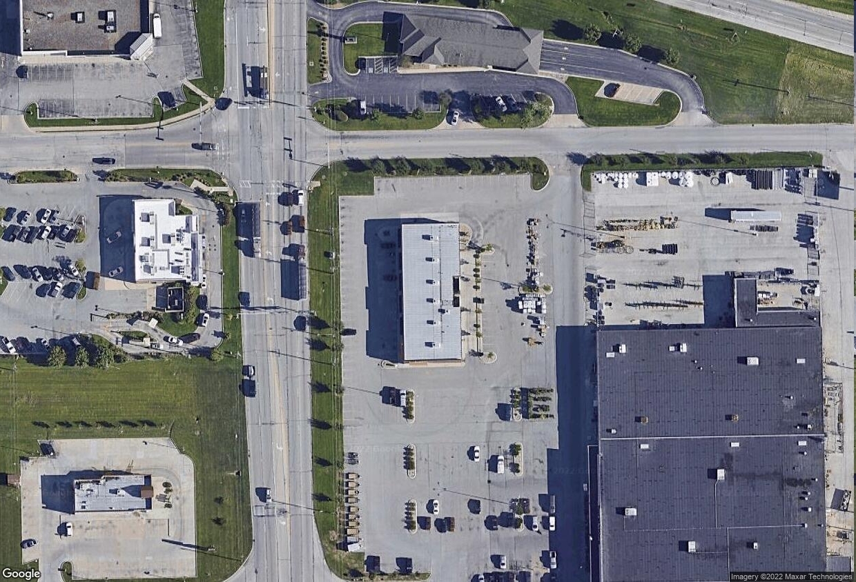
1910 S Mount Zion Rd
Decatur, IL
Eastgate Commons Add
09-13-28-101-009
SEC 28-16-3E~EAST GATE COMMONS ADD~LT 2 TIF
Regionalshoppingcenterormallwithanchorstore
Macon
X
Illinois
17115C0310D
2
2023
0.97 AC
2023
Springfield/Decatur
0023001086
Other Market Areas
DEMOGRAPHICS near 1910 S Mount Zion Rd
1 Mile
3 Mile
5 Mile
2024 Total Population
1,976
19,040
46,021
2029 Population
1,888
18,349
45,008
Pop Growth 2024-2029
(4.45%)
(3.63%)
(2.20%)
Average Age
46
44
41
2024 Total Households
856
8,425
19,806
HH Growth 2024-2029
(4.44%)
(3.69%)
(2.25%)
Median Household Inc
$79,987
$70,038
$47,145
Avg Household Size
2.20
2.20
2.20
2024 Avg HH Vehicles
2.00
2.00
2.00
Median Home Value
$148,181
$145,239
$115,785
Median Year Built
1968
1968
1962
Nearby Places
- Restaurants
- Banks
- Shops
- Fitness
- Groceries
SALE & LEASE HISTORY
LISTING DATE
SALE/LEASE

Nov 18, 2024
For Sale
Nearby Properties
Address
Land Use
TOTAL SIZE
Lot Size
Zoning
Address
Land Use
TOTAL SIZE
Lot Size
Zoning
23.63 AC
MUNICIPAL
Address
Land Use
TOTAL SIZE
Lot Size
Zoning
Address
Land Use
TOTAL SIZE
Lot Size
Zoning
25.59 AC
MUNICIPAL
Address
Land Use
TOTAL SIZE
Lot Size
Zoning
Address
Land Use
TOTAL SIZE
Lot Size
Zoning
6.36 AC
MUNICIPAL
Address
Land Use
TOTAL SIZE
Lot Size
Zoning
2.61 AC
MUNICIPAL
Address
Land Use
TOTAL SIZE
Lot Size
Zoning
21,555 SF
4.99 AC
MUNICIPAL
Address
Land Use
TOTAL SIZE
Lot Size
Zoning
4.64 AC
MUNICIPAL
Address
Land Use
TOTAL SIZE
Lot Size
Zoning
1.24 AC
MUNICIPAL
Address
Land Use
TOTAL SIZE
Lot Size
Zoning
6.20 AC
MUNICIPAL
Address
Land Use
TOTAL SIZE
Lot Size
Zoning
6.96 AC
MUNICIPAL
Address
Land Use
TOTAL SIZE
Lot Size
Zoning
7.74 AC
MUNICIPAL
Address
Land Use
TOTAL SIZE
Lot Size
Zoning
8.22 AC
MUNICIPAL
Address
Land Use
TOTAL SIZE
Lot Size
Zoning
4.05 AC
MUNICIPAL
Address
Land Use
TOTAL SIZE
Lot Size
Zoning
1.24 AC
MUNICIPAL
Address
Land Use
TOTAL SIZE
Lot Size
Zoning
6.28 AC
MUNICIPAL
Address
Land Use
TOTAL SIZE
Lot Size
Zoning
3.47 AC
MUNICIPAL
Address
Land Use
TOTAL SIZE
Lot Size
Zoning
2.89 AC
MUNICIPAL
Address
Land Use
TOTAL SIZE
Lot Size
Zoning
2.69 AC
MUNICIPAL
Address
Land Use
TOTAL SIZE
Lot Size
Zoning
2.66 AC
MUNICIPAL
Address
Land Use
TOTAL SIZE
Lot Size
Zoning
2.21 AC
MUNICIPAL
Address
Land Use
TOTAL SIZE
Lot Size
Zoning
2.24 AC
MUNICIPAL
Address
Land Use
TOTAL SIZE
Lot Size
Zoning
1.67 AC
MUNICIPAL
Address
Land Use
TOTAL SIZE
Lot Size
Zoning
48.84 AC
MUNICIPAL
Address
Land Use
TOTAL SIZE
Lot Size
Zoning
0.85 AC
MUNICIPAL
Address
Land Use
TOTAL SIZE
Lot Size
Zoning
7.87 AC
MUNICIPAL
Address
Land Use
TOTAL SIZE
Lot Size
Zoning
5,544 SF
1.30 AC
MUNICIPAL
Address
Land Use
TOTAL SIZE
Lot Size
Zoning
2.08 AC
MUNICIPAL
Address
Land Use
TOTAL SIZE
Lot Size
Zoning
7.63 AC
MUNICIPAL
Address
Land Use
TOTAL SIZE
Lot Size
Zoning
2.09 AC
MUNICIPAL
The World's #1 Commercial Real Estate Marketplace
Connect with us
© 2025 CoStar Group
The information above has been obtained from sources believed reliable. While we do not doubt its accuracy we have not verified it and make no guarantee, warranty or representation about it. It is your responsibility to independently confirm its accuracy and completeness. Any projections, opinions, assumptions, or estimates used are for example only and do not represent the current or future performance of the property. The value of this transaction to you depends on tax and other factors which should be evaluated by your tax, financial, and legal advisors. You and your advisors should conduct a careful, independent investigation of the property to determine to your satisfaction the suitability of the property for your needs.