Property Record
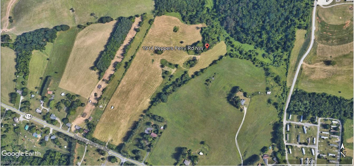
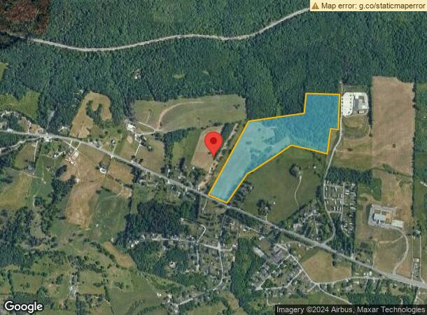
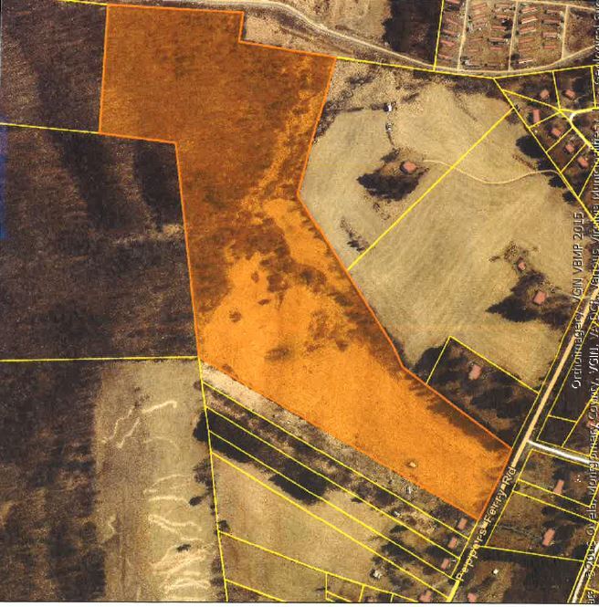
1914 Peppers Fry Rd Nw, Christiansburg, VA 24073
NEARBY LISTINGS FOR SALE OR LEASE
Property Detail
1914 Peppers Fry Rd Nw
Blacksburg-Christiansburg-Radford, VA
Lick Run Branch
000435
PEPPERS FERRY RD
Agriculturalland
Montgomery
X
Virginia
51121C0140C
38.71 AC
2024
Blacksburg & Wytheville
2024
Other Market Areas
021202
DEMOGRAPHICS near 1914 Peppers Fry Rd Nw
1 Mile
3 Mile
5 Mile
2024 Total Population
1,661
14,879
49,919
2029 Population
1,623
14,762
49,453
Pop Growth 2024-2029
(2.29%)
(0.79%)
(0.93%)
Average Age
40
41
38
2024 Total Households
672
6,367
21,704
HH Growth 2024-2029
(2.23%)
(0.75%)
(0.96%)
Median Household Inc
$86,206
$74,541
$58,503
Avg Household Size
2.40
2.20
2.20
2024 Avg HH Vehicles
2.00
2.00
2.00
Median Home Value
$244,405
$253,002
$268,785
Median Year Built
1996
1996
1988
Nearby Places
- Restaurants
- Banks
- Shops
- Fitness
- Groceries
PUBLIC TRANSPORTATION
AIRPORT
Roanoke/Blacksburg Regional (Woodrum Field)
DRIVE
WALK
Distance
Roanoke/Blacksburg Regional (Woodrum Field)
54 min
37.4 mi
Freight Ports
Virginia Port Authority - Richmond
DRIVE
WALK
Distance
Virginia Port Authority - Richmond
256 min
221.3 mi
SALE & LEASE HISTORY
LISTING DATE
SALE/LEASE

Apr 29, 2020
For Sale
Nearby Properties
Address
Land Use
TOTAL SIZE
Lot Size
Zoning
Address
Land Use
TOTAL SIZE
Lot Size
Zoning
96,768 SF
20.18 AC
RM1
Address
Land Use
TOTAL SIZE
Lot Size
Zoning
33.70 AC
A1
Address
Land Use
TOTAL SIZE
Lot Size
Zoning
151,388 SF
18.29 AC
B3
Address
Land Use
TOTAL SIZE
Lot Size
Zoning
222,902 SF
43.69 AC
I2
Address
Land Use
TOTAL SIZE
Lot Size
Zoning
151,450 SF
13.88 AC
B3
Address
Land Use
TOTAL SIZE
Lot Size
Zoning
538,247 SF
54.60 AC
B3
Address
Land Use
TOTAL SIZE
Lot Size
Zoning
200,004 SF
23.11 AC
B3
Address
Land Use
TOTAL SIZE
Lot Size
Zoning
124,503 SF
11.30 AC
B3
Address
Land Use
TOTAL SIZE
Lot Size
Zoning
108,510 SF
11.89 AC
B3
Address
Land Use
TOTAL SIZE
Lot Size
Zoning
37,056 SF
10.39 AC
A1
Address
Land Use
TOTAL SIZE
Lot Size
Zoning
61,328 SF
2.33 AC
B3
Address
Land Use
TOTAL SIZE
Lot Size
Zoning
99,595 SF
11.92 AC
B3
Address
Land Use
TOTAL SIZE
Lot Size
Zoning
Address
Land Use
TOTAL SIZE
Lot Size
Zoning
2,040 SF
45.31 AC
PMR
Address
Land Use
TOTAL SIZE
Lot Size
Zoning
75,776 SF
4.66 AC
RM1
Address
Land Use
TOTAL SIZE
Lot Size
Zoning
43,200 SF
2.30 AC
B3
Address
Land Use
TOTAL SIZE
Lot Size
Zoning
48,678 SF
0.03 AC
A1
Address
Land Use
TOTAL SIZE
Lot Size
Zoning
423,796 SF
53.92 AC
I2
Address
Land Use
TOTAL SIZE
Lot Size
Zoning
1,712 SF
131.68 AC
A1
Address
Land Use
TOTAL SIZE
Lot Size
Zoning
73,216 SF
5.76 AC
RM1
Address
Land Use
TOTAL SIZE
Lot Size
Zoning
95,224 SF
7.96 AC
B3
Address
Land Use
TOTAL SIZE
Lot Size
Zoning
63,600 SF
14.50 AC
RM1
Address
Land Use
TOTAL SIZE
Lot Size
Zoning
50,627 SF
3.04 AC
B3
Address
Land Use
TOTAL SIZE
Lot Size
Zoning
3,600 SF
88.96 AC
A1
Address
Land Use
TOTAL SIZE
Lot Size
Zoning
52,340 SF
6.36 AC
B3
Address
Land Use
TOTAL SIZE
Lot Size
Zoning
1,688 SF
29.96 AC
A1
Address
Land Use
TOTAL SIZE
Lot Size
Zoning
62,740 SF
6.20 AC
B3
Address
Land Use
TOTAL SIZE
Lot Size
Zoning
20,100 SF
5.20 AC
B3
Address
Land Use
TOTAL SIZE
Lot Size
Zoning
61,440 SF
1.01 AC
B3
Address
Land Use
TOTAL SIZE
Lot Size
Zoning
39,255 SF
4.27 AC
B3
The World's #1 Commercial Real Estate Marketplace
Connect with us
© 2025 CoStar Group
The information above has been obtained from sources believed reliable. While we do not doubt its accuracy we have not verified it and make no guarantee, warranty or representation about it. It is your responsibility to independently confirm its accuracy and completeness. Any projections, opinions, assumptions, or estimates used are for example only and do not represent the current or future performance of the property. The value of this transaction to you depends on tax and other factors which should be evaluated by your tax, financial, and legal advisors. You and your advisors should conduct a careful, independent investigation of the property to determine to your satisfaction the suitability of the property for your needs.