Property Record
1919 Cedar Fork Dr, Greensboro, NC 27407
NEARBY LISTINGS FOR SALE OR LEASE
Property Detail
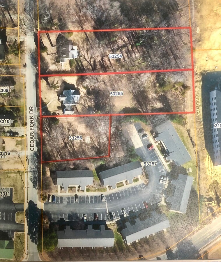
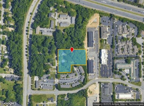
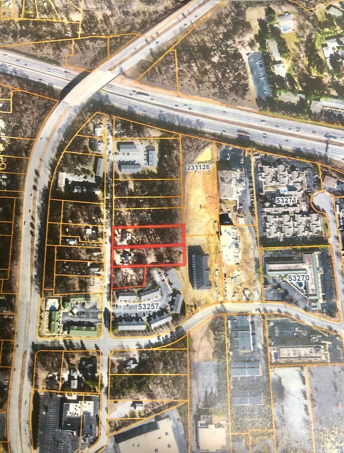
1919 Cedar Fork Dr
Greensboro-High Point, NC
Old John King Farm
0053255
Guilford
Sfr
North Carolina
X
2.20 AC
3710784300J
Central Guilford County
2,410 SF
Greensboro/Winston-Salem
DEMOGRAPHICS near 1919 Cedar Fork Dr
1 Mile
3 Mile
5 Mile
2024 Total Population
9,690
80,439
186,950
2029 Population
9,621
80,143
186,601
Pop Growth 2024-2029
(0.71%)
(0.37%)
(0.19%)
Average Age
35
37
37
2024 Total Households
3,946
32,799
76,384
HH Growth 2024-2029
(0.66%)
(0.32%)
(0.10%)
Median Household Inc
$38,136
$49,399
$53,491
Avg Household Size
2.40
2.30
2.20
2024 Avg HH Vehicles
2.00
2.00
2.00
Median Home Value
$89,696
$160,937
$193,962
Median Year Built
1977
1978
1980
Nearby Places
- Restaurants
- Banks
- Shops
- Fitness
- Groceries
PUBLIC TRANSPORTATION
COMMUTER RAIL
Greensboro Station (Piedmont - North Carolina by Train (NC Train))
DRIVE
WALK
Distance
Greensboro Station (Piedmont - North Carolina by Train (NC Train))
9 min
4.6 mi
AIRPORT
Piedmont Triad International
DRIVE
WALK
Distance
Piedmont Triad International
19 min
9.4 mi
Freight Ports
Virginia Port Authority - Richmond
DRIVE
WALK
Distance
Virginia Port Authority - Richmond
232 min
201.0 mi
SALE & LEASE HISTORY
LISTING DATE
SALE/LEASE

Jun 23, 2021
For Sale
Nearby Properties
Address
Land Use
TOTAL SIZE
Lot Size
Zoning
Address
Land Use
TOTAL SIZE
Lot Size
Zoning
1,864,781 SF
96.17 AC
PI
Address
Land Use
TOTAL SIZE
Lot Size
Zoning
671,937 SF
44.01 AC
PI
Address
Land Use
TOTAL SIZE
Lot Size
Zoning
892,800 SF
51.53 AC
HI
Address
Land Use
TOTAL SIZE
Lot Size
Zoning
733,612 SF
19.38 AC
PI
Address
Land Use
TOTAL SIZE
Lot Size
Zoning
1,307,155 SF
60.56 AC
C-H
Address
Land Use
TOTAL SIZE
Lot Size
Zoning
957,290 SF
18.71 AC
C-H
Address
Land Use
TOTAL SIZE
Lot Size
Zoning
279,853 SF
19.80 AC
CD-RM-18
Address
Land Use
TOTAL SIZE
Lot Size
Zoning
138,843 SF
115.56 AC
CU-LI
Address
Land Use
TOTAL SIZE
Lot Size
Zoning
228,253 SF
11.21 AC
RM-18
Address
Land Use
TOTAL SIZE
Lot Size
Zoning
287,581 SF
39.35 AC
PI
Address
Land Use
TOTAL SIZE
Lot Size
Zoning
361,604 SF
16.55 AC
RM-18
Address
Land Use
TOTAL SIZE
Lot Size
Zoning
252,351 SF
9.48 AC
RM-18
Address
Land Use
TOTAL SIZE
Lot Size
Zoning
231,597 SF
8.46 AC
PD-R
Address
Land Use
TOTAL SIZE
Lot Size
Zoning
228,994 SF
15.59 AC
AG
Address
Land Use
TOTAL SIZE
Lot Size
Zoning
311,199 SF
20.79 AC
CU-RM-12
Address
Land Use
TOTAL SIZE
Lot Size
Zoning
136,130 SF
14.63 AC
C-H
Address
Land Use
TOTAL SIZE
Lot Size
Zoning
157,596 SF
20.24 AC
CU-GB
Address
Land Use
TOTAL SIZE
Lot Size
Zoning
254,761 SF
13.05 AC
CD-RM-18
Address
Land Use
TOTAL SIZE
Lot Size
Zoning
182,499 SF
6.74 AC
O
Address
Land Use
TOTAL SIZE
Lot Size
Zoning
188,655 SF
13.16 AC
RM-18
Address
Land Use
TOTAL SIZE
Lot Size
Zoning
234,712 SF
13 AC
PI
Address
Land Use
TOTAL SIZE
Lot Size
Zoning
116,713 SF
4.53 AC
C-M
Address
Land Use
TOTAL SIZE
Lot Size
Zoning
211,723 SF
20.26 AC
RM-18
Address
Land Use
TOTAL SIZE
Lot Size
Zoning
135,516 SF
3.53 AC
PI
Address
Land Use
TOTAL SIZE
Lot Size
Zoning
48,532 SF
11.60 AC
HI
Address
Land Use
TOTAL SIZE
Lot Size
Zoning
132,905 SF
10.26 AC
CU-RM-8
Address
Land Use
TOTAL SIZE
Lot Size
Zoning
144,746 SF
8.17 AC
AG
Address
Land Use
TOTAL SIZE
Lot Size
Zoning
250,084 SF
5.46 AC
PI
Address
Land Use
TOTAL SIZE
Lot Size
Zoning
193,716 SF
10.81 AC
CU-CP
Address
Land Use
TOTAL SIZE
Lot Size
Zoning
104,984 SF
1.97 AC
C-M
The World's #1 Commercial Real Estate Marketplace
Connect with us
© 2025 CoStar Group
The information above has been obtained from sources believed reliable. While we do not doubt its accuracy we have not verified it and make no guarantee, warranty or representation about it. It is your responsibility to independently confirm its accuracy and completeness. Any projections, opinions, assumptions, or estimates used are for example only and do not represent the current or future performance of the property. The value of this transaction to you depends on tax and other factors which should be evaluated by your tax, financial, and legal advisors. You and your advisors should conduct a careful, independent investigation of the property to determine to your satisfaction the suitability of the property for your needs.