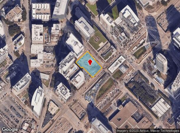
Property Record
2121 N Harwood St, Dallas, TX 75201

Current Lease Availabilities
NEARBY LISTINGS FOR SALE OR LEASE
Property Detail
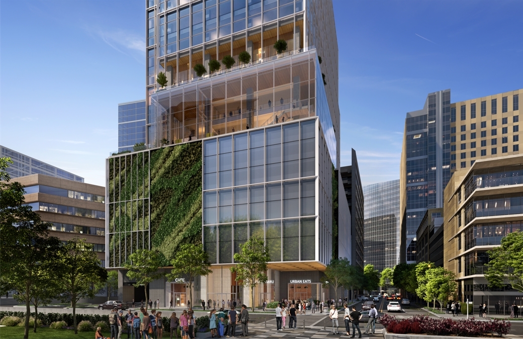
2121 N Harwood St
Dallas-Fort Worth-Arlington, TX
Woolf
000524000001B0000
WOOLF BLK 524 LT 1B INT201000325113 DD12212010 CO-DC 0524 000 01B00 6DA0524 000
Financialbuilding
Dallas
X
Texas
48113C0345J
1b
2024
0.92 AC
2023
Uptown/Turtle Creek
002100
Dallas/Ft Worth
3,190 SF
DEMOGRAPHICS near 2121 N Harwood St
1 Mile
3 Mile
5 Mile
2024 Total Population
39,993
197,975
392,803
2029 Population
40,924
201,885
396,460
Pop Growth 2024-2029
+ 2.33%
+ 1.97%
+ 0.93%
Average Age
35
36
37
2024 Total Households
26,508
107,286
181,759
HH Growth 2024-2029
+ 2.24%
+ 1.92%
+ 1.08%
Median Household Inc
$91,656
$73,290
$70,890
Avg Household Size
1.50
1.70
2.10
2024 Avg HH Vehicles
1.00
1.00
2.00
Median Home Value
$453,947
$419,179
$425,189
Median Year Built
2005
2000
1991
Nearby Places
- Restaurants
- Banks
- Shops
- Fitness
- Groceries
PUBLIC TRANSPORTATION
TRANSIT/SUBWAY
Mckinney And Harwood - North (McKinney Avenue Streetcar - Dallas Area Rapid Transit (DART))
DRIVE
WALK
Distance
Mckinney And Harwood - North (McKinney Avenue Streetcar - Dallas Area Rapid Transit (DART))
0 min
2 min
0.1 mi
Olive (MCKINNEY AVENUE TROLLEY - Dallas Area Rapid Transit (DART))
DRIVE
WALK
Distance
Olive (MCKINNEY AVENUE TROLLEY - Dallas Area Rapid Transit (DART))
1 min
3 min
0.2 mi
Mckinney And Olive (McKinney Avenue Streetcar - Dallas Area Rapid Transit (DART))
DRIVE
WALK
Distance
Mckinney And Olive (McKinney Avenue Streetcar - Dallas Area Rapid Transit (DART))
1 min
3 min
0.2 mi
Munger And Saint Paul (McKinney Avenue Streetcar - Dallas Area Rapid Transit (DART))
DRIVE
WALK
Distance
Munger And Saint Paul (McKinney Avenue Streetcar - Dallas Area Rapid Transit (DART))
0 min
3 min
0.2 mi
Olive (MCKINNEY AVENUE TROLLEY - Dallas Area Rapid Transit (DART))
DRIVE
WALK
Distance
Olive (MCKINNEY AVENUE TROLLEY - Dallas Area Rapid Transit (DART))
1 min
4 min
0.2 mi
COMMUTER RAIL
Medical/Market Center (Trinity Railway Express - Dallas Area Rapid Transit (DART))
DRIVE
WALK
Distance
Medical/Market Center (Trinity Railway Express - Dallas Area Rapid Transit (DART))
6 min
3.0 mi
Downtown Irving/Heritage Crossing Station (Trinity Railway Express - Dallas Area Rapid Transit (DART))
DRIVE
WALK
Distance
Downtown Irving/Heritage Crossing Station (Trinity Railway Express - Dallas Area Rapid Transit (DART))
17 min
9.9 mi
AIRPORT
Dallas Love Field
DRIVE
WALK
Distance
Dallas Love Field
11 min
5.3 mi
Dallas-Fort Worth International
DRIVE
WALK
Distance
Dallas-Fort Worth International
26 min
20.3 mi
Freight Ports
Port of Shreveport
DRIVE
WALK
Distance
Port of Shreveport
213 min
197.1 mi
Nearby Properties
Address
Land Use
TOTAL SIZE
Lot Size
Zoning
Address
Land Use
TOTAL SIZE
Lot Size
Zoning
2,658,374 SF
37.70 AC
Z116
Address
Land Use
TOTAL SIZE
Lot Size
Zoning
3,713,071 SF
9.94 AC
Address
Land Use
TOTAL SIZE
Lot Size
Zoning
1,298,826 SF
33.16 AC
Z163
Address
Land Use
TOTAL SIZE
Lot Size
Zoning
1,676,176 SF
2.18 AC
Z239
Address
Land Use
TOTAL SIZE
Lot Size
Zoning
1,308,710 SF
8.42 AC
Z21
Address
Land Use
TOTAL SIZE
Lot Size
Zoning
906,730 SF
3.09 AC
Z239
Address
Land Use
TOTAL SIZE
Lot Size
Zoning
1,003,498 SF
22.15 AC
Z116
Address
Land Use
TOTAL SIZE
Lot Size
Zoning
815,000 SF
7.20 AC
Z239
Address
Land Use
TOTAL SIZE
Lot Size
Zoning
1,896,570 SF
18.08 AC
Z151
Address
Land Use
TOTAL SIZE
Lot Size
Zoning
731,849 SF
3.13 AC
Z239
Address
Land Use
TOTAL SIZE
Lot Size
Zoning
864,909 SF
3.02 AC
Z248
Address
Land Use
TOTAL SIZE
Lot Size
Zoning
504,533 SF
9.95 AC
Z151
Address
Land Use
TOTAL SIZE
Lot Size
Zoning
1,026,046 SF
2.89 AC
Z248
Address
Land Use
TOTAL SIZE
Lot Size
Zoning
1,980,000 SF
2.57 AC
Z21
Address
Land Use
TOTAL SIZE
Lot Size
Zoning
1,480,246 SF
1.86 AC
Z21
Address
Land Use
TOTAL SIZE
Lot Size
Zoning
857,292 SF
1.47 AC
Z239
Address
Land Use
TOTAL SIZE
Lot Size
Zoning
602,716 SF
11.21 AC
Z239
Address
Land Use
TOTAL SIZE
Lot Size
Zoning
763,198 SF
3 AC
Z248
Address
Land Use
TOTAL SIZE
Lot Size
Zoning
638,046 SF
2.10 AC
Z239
Address
Land Use
TOTAL SIZE
Lot Size
Zoning
893,159 SF
1.17 AC
Z21
Address
Land Use
TOTAL SIZE
Lot Size
Zoning
486,300 SF
1.55 AC
Z239
Address
Land Use
TOTAL SIZE
Lot Size
Zoning
784,725 SF
2.33 AC
Z239
Address
Land Use
TOTAL SIZE
Lot Size
Zoning
432,919 SF
0.68 AC
Z21
Address
Land Use
TOTAL SIZE
Lot Size
Zoning
512,667 SF
16.10 AC
Z151
Address
Land Use
TOTAL SIZE
Lot Size
Zoning
2,326,857 SF
4.42 AC
Z21
Address
Land Use
TOTAL SIZE
Lot Size
Zoning
676,930 SF
1.38 AC
Z248
Address
Land Use
TOTAL SIZE
Lot Size
Zoning
2,695,010 SF
8.68 AC
Z239
Address
Land Use
TOTAL SIZE
Lot Size
Zoning
1,870,348 SF
12.70 AC
Z151
Address
Land Use
TOTAL SIZE
Lot Size
Zoning
1,003,243 SF
2.07 AC
Z21
Address
Land Use
TOTAL SIZE
Lot Size
Zoning
818,188 SF
2.89 AC
Z239
The World's #1 Commercial Real Estate Marketplace
Connect with us
© 2025 CoStar Group
The information above has been obtained from sources believed reliable. While we do not doubt its accuracy we have not verified it and make no guarantee, warranty or representation about it. It is your responsibility to independently confirm its accuracy and completeness. Any projections, opinions, assumptions, or estimates used are for example only and do not represent the current or future performance of the property. The value of this transaction to you depends on tax and other factors which should be evaluated by your tax, financial, and legal advisors. You and your advisors should conduct a careful, independent investigation of the property to determine to your satisfaction the suitability of the property for your needs.