Property Record
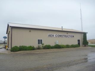
1920 Lacon Dr, Galesburg, IL 61401
NEARBY LISTINGS FOR SALE OR LEASE
Property Detail
1920 Lacon Dr
99-21-300-016
Aeh Sub
Commercialnec
AEH SUB LOT 2 EZ
X
Knox
17187C0200D
Illinois
2023
1.48 AC
2023
Other Market Areas
000900
Galesburg, IL
DEMOGRAPHICS near 1920 Lacon Dr
1 Mile
3 Mile
5 Mile
2024 Total Population
643
17,549
31,518
2029 Population
631
17,077
30,527
Pop Growth 2024-2029
(1.87%)
(2.69%)
(3.14%)
Average Age
41
40
42
2024 Total Households
306
6,761
12,953
HH Growth 2024-2029
(2.29%)
(3.02%)
(3.44%)
Median Household Inc
$24,647
$35,970
$40,916
Avg Household Size
2.10
2.10
2.10
2024 Avg HH Vehicles
1.00
1.00
2.00
Median Home Value
$53,181
$66,488
$78,961
Median Year Built
1971
1950
1954
Nearby Places
- Restaurants
- Banks
- Shops
- Fitness
- Groceries
PUBLIC TRANSPORTATION
COMMUTER RAIL
Galesburg Amtrak Station (California Zephyr - Amtrak, Carl Sandburg - Amtrak, Illinois Zephyr - Amtrak, Southwest Chief - Amtrak)
DRIVE
WALK
Distance
Galesburg Amtrak Station (California Zephyr - Amtrak, Carl Sandburg - Amtrak, Illinois Zephyr - Amtrak, Southwest Chief - Amtrak)
7 min
3.0 mi
Freight Ports
Port Milwaukee
DRIVE
WALK
Distance
Port Milwaukee
270 min
240.6 mi
Nearby Properties
Address
Land Use
TOTAL SIZE
Lot Size
Zoning
Address
Land Use
TOTAL SIZE
Lot Size
Zoning
3.47 AC
Address
Land Use
TOTAL SIZE
Lot Size
Zoning
4.82 AC
Address
Land Use
TOTAL SIZE
Lot Size
Zoning
45.44 AC
Address
Land Use
TOTAL SIZE
Lot Size
Zoning
1.43 AC
Address
Land Use
TOTAL SIZE
Lot Size
Zoning
1.65 AC
Address
Land Use
TOTAL SIZE
Lot Size
Zoning
8.28 AC
Address
Land Use
TOTAL SIZE
Lot Size
Zoning
28.41 AC
Address
Land Use
TOTAL SIZE
Lot Size
Zoning
9,928 SF
1.36 AC
Address
Land Use
TOTAL SIZE
Lot Size
Zoning
35.08 AC
Address
Land Use
TOTAL SIZE
Lot Size
Zoning
2.11 AC
Address
Land Use
TOTAL SIZE
Lot Size
Zoning
11.70 AC
Address
Land Use
TOTAL SIZE
Lot Size
Zoning
Address
Land Use
TOTAL SIZE
Lot Size
Zoning
Address
Land Use
TOTAL SIZE
Lot Size
Zoning
4.96 AC
Address
Land Use
TOTAL SIZE
Lot Size
Zoning
13.06 AC
Address
Land Use
TOTAL SIZE
Lot Size
Zoning
20.02 AC
Address
Land Use
TOTAL SIZE
Lot Size
Zoning
25.23 AC
Address
Land Use
TOTAL SIZE
Lot Size
Zoning
1.39 AC
Address
Land Use
TOTAL SIZE
Lot Size
Zoning
0.43 AC
Address
Land Use
TOTAL SIZE
Lot Size
Zoning
0.80 AC
Address
Land Use
TOTAL SIZE
Lot Size
Zoning
Address
Land Use
TOTAL SIZE
Lot Size
Zoning
Address
Land Use
TOTAL SIZE
Lot Size
Zoning
1.11 AC
Address
Land Use
TOTAL SIZE
Lot Size
Zoning
5.09 AC
Address
Land Use
TOTAL SIZE
Lot Size
Zoning
18,080 SF
9.62 AC
Address
Land Use
TOTAL SIZE
Lot Size
Zoning
1,092 SF
10 AC
Address
Land Use
TOTAL SIZE
Lot Size
Zoning
Address
Land Use
TOTAL SIZE
Lot Size
Zoning
0.64 AC
Address
Land Use
TOTAL SIZE
Lot Size
Zoning
832 SF
0.21 AC
Address
Land Use
TOTAL SIZE
Lot Size
Zoning
2.53 AC
The World's #1 Commercial Real Estate Marketplace
Connect with us
© 2025 CoStar Group
The information above has been obtained from sources believed reliable. While we do not doubt its accuracy we have not verified it and make no guarantee, warranty or representation about it. It is your responsibility to independently confirm its accuracy and completeness. Any projections, opinions, assumptions, or estimates used are for example only and do not represent the current or future performance of the property. The value of this transaction to you depends on tax and other factors which should be evaluated by your tax, financial, and legal advisors. You and your advisors should conduct a careful, independent investigation of the property to determine to your satisfaction the suitability of the property for your needs.