Property Record
1923 W Highway 66 Hwy, Winslow, AZ 86047
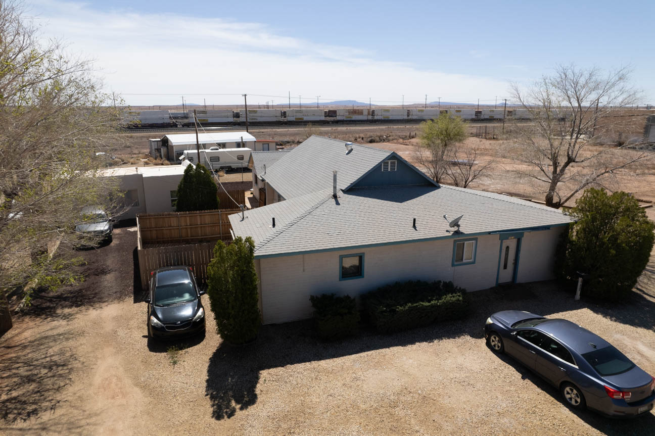
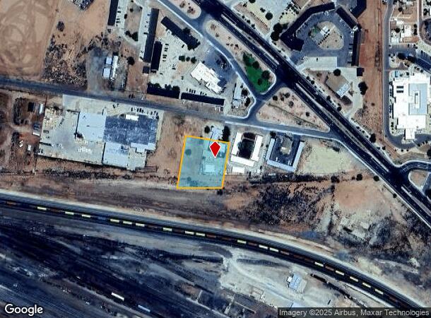
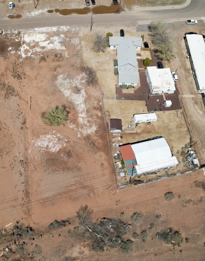
This Property Is For Sale
NEARBY LISTINGS FOR SALE OR LEASE
-
-
View all Winslow listings for sale on LoopNet.com
Property Detail
1923 W Highway 66 Hwy
Show Low, AZ
Westwood Village
103-12-051
Navajo
Duplex
Arizona
X
1.03 AC
04017C3012F
Arizona Northeast & Holbrook Area
3,555 SF
Other Market Areas
DEMOGRAPHICS near 1923 W Highway 66 Hwy
1 Mile
3 Mile
5 Mile
2024 Total Population
3,944
9,701
10,589
2029 Population
4,091
10,156
11,143
Pop Growth 2024-2029
+ 3.73%
+ 4.69%
+ 5.23%
Average Age
36
36
37
2024 Total Households
1,255
3,194
3,496
HH Growth 2024-2029
+ 3.51%
+ 4.60%
+ 5.23%
Median Household Inc
$52,723
$46,659
$49,554
Avg Household Size
2.80
2.70
2.70
2024 Avg HH Vehicles
2.00
2.00
2.00
Median Home Value
$98,010
$105,088
$110,044
Median Year Built
1974
1971
1973
Nearby Places
- Restaurants
- Banks
- Shops
- Fitness
- Groceries
PUBLIC TRANSPORTATION
COMMUTER RAIL
Winslow Amtrak (Southwest Chief - Amtrak)
DRIVE
WALK
Distance
Winslow Amtrak (Southwest Chief - Amtrak)
3 min
1.6 mi
Freight Ports
Port of San Diego
DRIVE
WALK
Distance
Port of San Diego
590 min
543.5 mi
Nearby Properties
Address
Land Use
TOTAL SIZE
Lot Size
Zoning
Address
Land Use
TOTAL SIZE
Lot Size
Zoning
15,534 SF
12.69 AC
MUNICIPAL
Address
Land Use
TOTAL SIZE
Lot Size
Zoning
92,717 SF
7.56 AC
MUNICIPAL
Address
Land Use
TOTAL SIZE
Lot Size
Zoning
50,145 SF
3.55 AC
MUNICIPAL
Address
Land Use
TOTAL SIZE
Lot Size
Zoning
43,657 SF
4.71 AC
MUNICIPAL
Address
Land Use
TOTAL SIZE
Lot Size
Zoning
28,741 SF
6.05 AC
MUNICIPAL
Address
Land Use
TOTAL SIZE
Lot Size
Zoning
44,270 SF
4.47 AC
MUNICIPAL
Address
Land Use
TOTAL SIZE
Lot Size
Zoning
69,675 SF
18.48 AC
MUNICIPAL
Address
Land Use
TOTAL SIZE
Lot Size
Zoning
28,866 SF
2.93 AC
MUNICIPAL
Address
Land Use
TOTAL SIZE
Lot Size
Zoning
41,459 SF
1.93 AC
MUNICIPAL
Address
Land Use
TOTAL SIZE
Lot Size
Zoning
11,772 SF
3.60 AC
MUNICIPAL
Address
Land Use
TOTAL SIZE
Lot Size
Zoning
33,500 SF
6.49 AC
MUNICIPAL
Address
Land Use
TOTAL SIZE
Lot Size
Zoning
28,066 SF
1.17 AC
MUNICIPAL
Address
Land Use
TOTAL SIZE
Lot Size
Zoning
37,975 SF
1.07 AC
MUNICIPAL
Address
Land Use
TOTAL SIZE
Lot Size
Zoning
46,793 SF
5.18 AC
MUNICIPAL
Address
Land Use
TOTAL SIZE
Lot Size
Zoning
11,840 SF
10 AC
MUNICIPAL
Address
Land Use
TOTAL SIZE
Lot Size
Zoning
27,841 SF
1.29 AC
MUNICIPAL
Address
Land Use
TOTAL SIZE
Lot Size
Zoning
11,337 SF
1.04 AC
MUNICIPAL
Address
Land Use
TOTAL SIZE
Lot Size
Zoning
43,479 SF
7.40 AC
IND-2
Address
Land Use
TOTAL SIZE
Lot Size
Zoning
14,700 SF
20.22 AC
MUNICIPAL
Address
Land Use
TOTAL SIZE
Lot Size
Zoning
45,423 SF
0.47 AC
MUNICIPAL
Address
Land Use
TOTAL SIZE
Lot Size
Zoning
11,323 SF
7.47 AC
MUNICIPAL
Address
Land Use
TOTAL SIZE
Lot Size
Zoning
10,395 SF
9.80 AC
MUNICIPAL
Address
Land Use
TOTAL SIZE
Lot Size
Zoning
8,687 SF
1.23 AC
MUNICIPAL
Address
Land Use
TOTAL SIZE
Lot Size
Zoning
45,423 SF
0.68 AC
MUNICIPAL
Address
Land Use
TOTAL SIZE
Lot Size
Zoning
12,565 SF
1.16 AC
MUNICIPAL
Address
Land Use
TOTAL SIZE
Lot Size
Zoning
22,047 SF
1.10 AC
MUNICIPAL
Address
Land Use
TOTAL SIZE
Lot Size
Zoning
16,927 SF
13.43 AC
MUNICIPAL
Address
Land Use
TOTAL SIZE
Lot Size
Zoning
30,366 SF
0.98 AC
MUNICIPAL
The World's #1 Commercial Real Estate Marketplace
Connect with us
© 2025 CoStar Group
The information above has been obtained from sources believed reliable. While we do not doubt its accuracy we have not verified it and make no guarantee, warranty or representation about it. It is your responsibility to independently confirm its accuracy and completeness. Any projections, opinions, assumptions, or estimates used are for example only and do not represent the current or future performance of the property. The value of this transaction to you depends on tax and other factors which should be evaluated by your tax, financial, and legal advisors. You and your advisors should conduct a careful, independent investigation of the property to determine to your satisfaction the suitability of the property for your needs.