Property Record
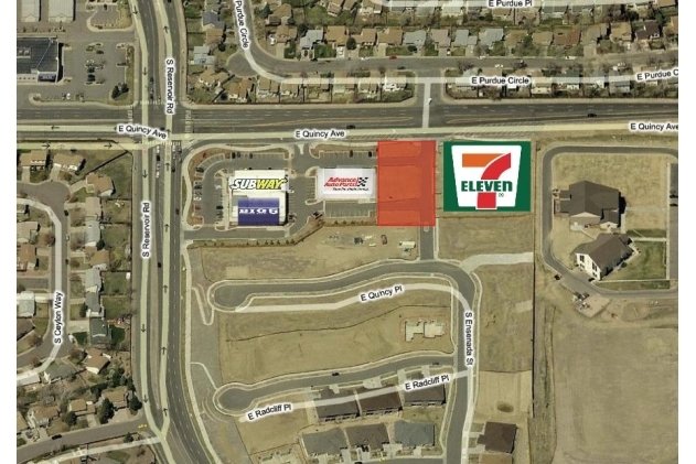
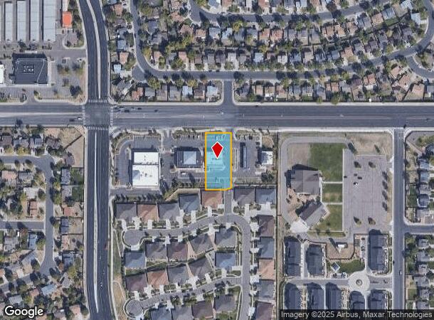
19370 E Quincy Ave, Aurora, CO 80015
NEARBY LISTINGS FOR SALE OR LEASE
Property Detail
19370 E Quincy Ave
Denver-Aurora-Lakewood, CO
Quincy Marketplace Sub 1St Flg
2073-10-1-24-003
SUBDIVISIONCD 050790 SUBDIVISIONNAME QUINCY MARKETPLACE SUB 1ST FLG BLOCK 001 LOT 003 LOT 3 BLK 1 QUINCY MARKETPLACE SUB 1ST FLG
Storebuilding
Arapahoe
X
Colorado
08005C0194L
003
2023
0.59 AC
2024
Aurora
085900
Denver
4,212 SF
DEMOGRAPHICS near 19370 E Quincy Ave
1 Mile
3 Mile
5 Mile
2024 Total Population
18,560
141,222
264,257
2029 Population
18,470
140,784
264,365
Pop Growth 2024-2029
(0.48%)
(0.31%)
+ 0.04%
Average Age
37
38
39
2024 Total Households
6,022
46,677
94,488
HH Growth 2024-2029
(0.63%)
(0.41%)
(0.01%)
Median Household Inc
$107,729
$108,115
$95,489
Avg Household Size
3.00
2.90
2.70
2024 Avg HH Vehicles
2.00
2.00
2.00
Median Home Value
$432,401
$453,461
$451,444
Median Year Built
1989
1990
1990
Nearby Places
- Restaurants
- Banks
- Shops
- Fitness
- Groceries
PUBLIC TRANSPORTATION
AIRPORT
Denver International
DRIVE
WALK
Distance
Denver International
29 min
22.6 mi
SALE & LEASE HISTORY
LISTING DATE
SALE/LEASE

Sep 24, 2016
For Sale
Nearby Properties
Address
Land Use
TOTAL SIZE
Lot Size
Zoning
Address
Land Use
TOTAL SIZE
Lot Size
Zoning
525,600 SF
57.90 AC
Address
Land Use
TOTAL SIZE
Lot Size
Zoning
277,940 SF
31.61 AC
Address
Land Use
TOTAL SIZE
Lot Size
Zoning
328,000 SF
33.52 AC
PUD
Address
Land Use
TOTAL SIZE
Lot Size
Zoning
368,462 SF
11.68 AC
RZMF
Address
Land Use
TOTAL SIZE
Lot Size
Zoning
168,500 SF
24.03 AC
Address
Land Use
TOTAL SIZE
Lot Size
Zoning
142,378 SF
14.64 AC
Address
Land Use
TOTAL SIZE
Lot Size
Zoning
376,563 SF
12.17 AC
AMU
Address
Land Use
TOTAL SIZE
Lot Size
Zoning
105,244 SF
12.64 AC
RPCZD
Address
Land Use
TOTAL SIZE
Lot Size
Zoning
14,600 SF
0.28 AC
WDC2A*
Address
Land Use
TOTAL SIZE
Lot Size
Zoning
176,000 SF
10.83 AC
PUD
Address
Land Use
TOTAL SIZE
Lot Size
Zoning
206,064 SF
25.38 AC
AMU
Address
Land Use
TOTAL SIZE
Lot Size
Zoning
344,071 SF
17.10 AC
Address
Land Use
TOTAL SIZE
Lot Size
Zoning
172,715 SF
4.23 AC
Address
Land Use
TOTAL SIZE
Lot Size
Zoning
114,838 SF
12.50 AC
Address
Land Use
TOTAL SIZE
Lot Size
Zoning
473.14 AC
AA1
Address
Land Use
TOTAL SIZE
Lot Size
Zoning
254,752 SF
14.71 AC
RZMF
Address
Land Use
TOTAL SIZE
Lot Size
Zoning
255,676 SF
13.97 AC
PUD
Address
Land Use
TOTAL SIZE
Lot Size
Zoning
140,000 SF
24.16 AC
AMU
Address
Land Use
TOTAL SIZE
Lot Size
Zoning
84,662 SF
8.14 AC
PUD
Address
Land Use
TOTAL SIZE
Lot Size
Zoning
96,480 SF
9.51 AC
PUD
Address
Land Use
TOTAL SIZE
Lot Size
Zoning
70,715 SF
13.57 AC
Address
Land Use
TOTAL SIZE
Lot Size
Zoning
234,516 SF
11.29 AC
RZMF
Address
Land Use
TOTAL SIZE
Lot Size
Zoning
60,600 SF
12.01 AC
ARPSF
Address
Land Use
TOTAL SIZE
Lot Size
Zoning
57,373 SF
14 AC
PUD
Address
Land Use
TOTAL SIZE
Lot Size
Zoning
55,800 SF
12.80 AC
Address
Land Use
TOTAL SIZE
Lot Size
Zoning
19.54 AC
RZSFD
Address
Land Use
TOTAL SIZE
Lot Size
Zoning
19.39 AC
PUD
Address
Land Use
TOTAL SIZE
Lot Size
Zoning
182,199 SF
6.01 AC
Address
Land Use
TOTAL SIZE
Lot Size
Zoning
45,430 SF
7.22 AC
Address
Land Use
TOTAL SIZE
Lot Size
Zoning
52,800 SF
11.51 AC
The World's #1 Commercial Real Estate Marketplace
Connect with us
© 2025 CoStar Group
The information above has been obtained from sources believed reliable. While we do not doubt its accuracy we have not verified it and make no guarantee, warranty or representation about it. It is your responsibility to independently confirm its accuracy and completeness. Any projections, opinions, assumptions, or estimates used are for example only and do not represent the current or future performance of the property. The value of this transaction to you depends on tax and other factors which should be evaluated by your tax, financial, and legal advisors. You and your advisors should conduct a careful, independent investigation of the property to determine to your satisfaction the suitability of the property for your needs.