Property Record
19389 County Road 102, Woodland, CA 95776


NEARBY LISTINGS FOR SALE OR LEASE
-
-
View all Woodland listings for sale on LoopNet.com
Property Detail
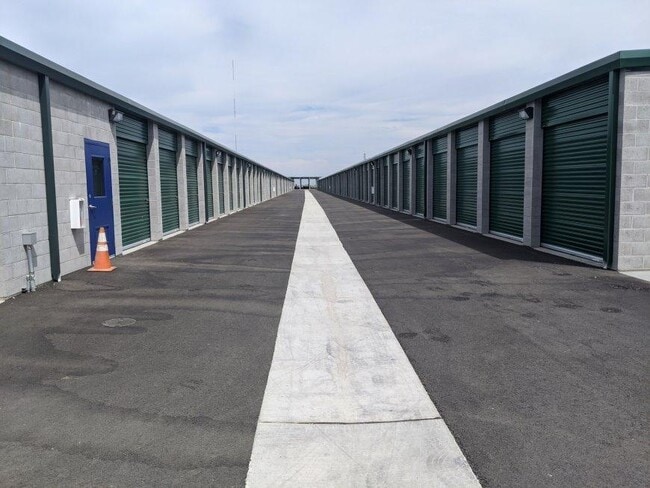
19389 County Road 102
Sacramento--Roseville--Arden-Arcade, CA
Cert Of Co
042-580-081-000
PCL A CERT OF COMP 2017-23516
Publicstorage
Yolo
AE
California
06113C0465H
8.83 AC
2024
Davis/Woodland
2025
Sacramento
011208
DEMOGRAPHICS near 19389 County Road 102
1 Mile
3 Mile
5 Mile
2024 Total Population
9,218
37,533
63,638
2029 Population
9,486
38,347
64,701
Pop Growth 2024-2029
+ 2.91%
+ 2.17%
+ 1.67%
Average Age
36
37
38
2024 Total Households
2,801
12,071
21,654
HH Growth 2024-2029
+ 3.00%
+ 2.20%
+ 1.66%
Median Household Inc
$116,626
$91,185
$79,135
Avg Household Size
3.20
3.00
2.80
2024 Avg HH Vehicles
2.00
2.00
2.00
Median Home Value
$639,356
$476,780
$467,780
Median Year Built
2003
1989
1981
Nearby Places
Map Layers
Map Styles
 Street
 Aerial
- Restaurants
- Banks
- Shops
- Fitness
- Groceries
PUBLIC TRANSPORTATION
COMMUTER RAIL
Davis (California Zephyr - Amtrak, Capitol Corridor - Amtrak, Coast Starlight - Amtrak)
DRIVE
WALK
Distance
Davis (California Zephyr - Amtrak, Capitol Corridor - Amtrak, Coast Starlight - Amtrak)
16 min
8.4 mi
AIRPORT
Sacramento International
DRIVE
WALK
Distance
Sacramento International
16 min
10.4 mi
Freight Ports
Port of Stockton
DRIVE
WALK
Distance
Port of Stockton
74 min
63.9 mi
Nearby Properties
Address
Land Use
TOTAL SIZE
Lot Size
Zoning
Address
Land Use
TOTAL SIZE
Lot Size
Zoning
1,835,779 SF
98.96 AC
I
Address
Land Use
TOTAL SIZE
Lot Size
Zoning
23.92 AC
M2
Address
Land Use
TOTAL SIZE
Lot Size
Zoning
370,791 SF
35.85 AC
I
Address
Land Use
TOTAL SIZE
Lot Size
Zoning
12,032 SF
0.12 AC
R3
Address
Land Use
TOTAL SIZE
Lot Size
Zoning
154,682 SF
15.17 AC
CH
Address
Land Use
TOTAL SIZE
Lot Size
Zoning
125,330 SF
10.06 AC
CH
Address
Land Use
TOTAL SIZE
Lot Size
Zoning
515,886 SF
71.53 AC
I
Address
Land Use
TOTAL SIZE
Lot Size
Zoning
348,386 SF
17.67 AC
RM
Address
Land Use
TOTAL SIZE
Lot Size
Zoning
150,269 SF
6.95 AC
R-M
Address
Land Use
TOTAL SIZE
Lot Size
Zoning
247,572 SF
17.04 AC
I
Address
Land Use
TOTAL SIZE
Lot Size
Zoning
400,450 SF
23.16 AC
I
Address
Land Use
TOTAL SIZE
Lot Size
Zoning
38.27 AC
I
Address
Land Use
TOTAL SIZE
Lot Size
Zoning
67,104 SF
0.32 AC
R25
Address
Land Use
TOTAL SIZE
Lot Size
Zoning
260,400 SF
12.30 AC
I
Address
Land Use
TOTAL SIZE
Lot Size
Zoning
260,400 SF
12.79 AC
I
Address
Land Use
TOTAL SIZE
Lot Size
Zoning
4.46 AC
C-3
Address
Land Use
TOTAL SIZE
Lot Size
Zoning
356,360 SF
26.50 AC
M2
Address
Land Use
TOTAL SIZE
Lot Size
Zoning
324,475 SF
22.49 AC
I
Address
Land Use
TOTAL SIZE
Lot Size
Zoning
427,073 SF
24.51 AC
I
Address
Land Use
TOTAL SIZE
Lot Size
Zoning
145,694 SF
9.26 AC
MDR20
Address
Land Use
TOTAL SIZE
Lot Size
Zoning
401,500 SF
22.08 AC
I
Address
Land Use
TOTAL SIZE
Lot Size
Zoning
401,500 SF
19.12 AC
I
Address
Land Use
TOTAL SIZE
Lot Size
Zoning
140,000 SF
13.63 AC
I
Address
Land Use
TOTAL SIZE
Lot Size
Zoning
24,500 SF
7.42 AC
EOZ
Address
Land Use
TOTAL SIZE
Lot Size
Zoning
26.48 AC
A1
Address
Land Use
TOTAL SIZE
Lot Size
Zoning
0.16 AC
PUD
Address
Land Use
TOTAL SIZE
Lot Size
Zoning
71,493 SF
1.98 AC
C3
Address
Land Use
TOTAL SIZE
Lot Size
Zoning
94,860 SF
11.70 AC
EOZ-I/PD
Address
Land Use
TOTAL SIZE
Lot Size
Zoning
128,755 SF
13.61 AC
C2
The World's #1 Commercial Real Estate Marketplace
Connect with us
© 2026 CoStar Group
The information above has been obtained from sources believed reliable. While we do not doubt its accuracy we have not verified it and make no guarantee, warranty or representation about it. It is your responsibility to independently confirm its accuracy and completeness. Any projections, opinions, assumptions, or estimates used are for example only and do not represent the current or future performance of the property. The value of this transaction to you depends on tax and other factors which should be evaluated by your tax, financial, and legal advisors. You and your advisors should conduct a careful, independent investigation of the property to determine to your satisfaction the suitability of the property for your needs.