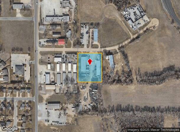
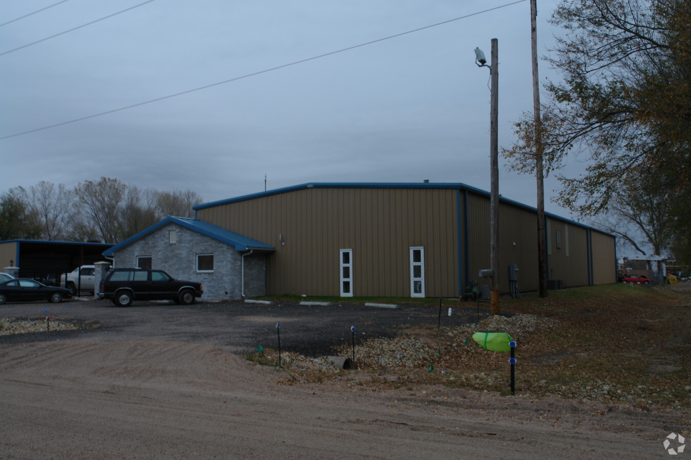
Property Record
1939 Emmett St, Haysville, KS 67060

NEARBY LISTINGS FOR SALE OR LEASE
-
-
View all Haysville listings for sale on LoopNet.com
Property Detail
1939 Emmett St
Wichita, KS
Haysville Industrial Park Add
242-04-0-23-01-004.00
LOT 1 BLOCK B HAYSVILLE INDUSTRIAL PARK ADD.
Warehouse
Sedgwick
X
Kansas
20173C0512G
1
2023
1.76 AC
2023
Derby/Haysville/Mulvane
005502
Wichita
14,396 SF
DEMOGRAPHICS near 1939 Emmett St
1 Mile
3 Mile
5 Mile
2024 Total Population
4,609
22,381
65,417
2029 Population
4,682
22,676
66,402
Pop Growth 2024-2029
+ 1.58%
+ 1.32%
+ 1.51%
Average Age
38
39
38
2024 Total Households
1,704
8,419
24,889
HH Growth 2024-2029
+ 1.58%
+ 1.26%
+ 1.35%
Median Household Inc
$68,319
$65,224
$59,456
Avg Household Size
2.60
2.60
2.50
2024 Avg HH Vehicles
2.00
2.00
2.00
Median Home Value
$178,023
$152,953
$151,895
Median Year Built
1994
1984
1985
Nearby Places
- Restaurants
- Banks
- Shops
- Fitness
- Groceries
PUBLIC TRANSPORTATION
AIRPORT
Wichita Dwight D Eisenhower Ntl
DRIVE
WALK
Distance
Wichita Dwight D Eisenhower Ntl
23 min
14.8 mi
Freight Ports
Tulsa Port Of Catoosa
DRIVE
WALK
Distance
Tulsa Port Of Catoosa
195 min
184.0 mi
Nearby Properties
Address
Land Use
TOTAL SIZE
Lot Size
Zoning
Address
Land Use
TOTAL SIZE
Lot Size
Zoning
214,769 SF
56.80 AC
RR
Address
Land Use
TOTAL SIZE
Lot Size
Zoning
174,602 SF
75.15 AC
A
Address
Land Use
TOTAL SIZE
Lot Size
Zoning
206,286 SF
32.38 AC
A
Address
Land Use
TOTAL SIZE
Lot Size
Zoning
31,449 SF
8.72 AC
DD
Address
Land Use
TOTAL SIZE
Lot Size
Zoning
31,440 SF
21.30 AC
SF-5
Address
Land Use
TOTAL SIZE
Lot Size
Zoning
62,798 SF
14.50 AC
A
Address
Land Use
TOTAL SIZE
Lot Size
Zoning
34,590 SF
1.31 AC
A
Address
Land Use
TOTAL SIZE
Lot Size
Zoning
36,354 SF
8.79 AC
A
Address
Land Use
TOTAL SIZE
Lot Size
Zoning
25,320 SF
0.51 AC
D
Address
Land Use
TOTAL SIZE
Lot Size
Zoning
31,268 SF
3.67 AC
D
Address
Land Use
TOTAL SIZE
Lot Size
Zoning
23,486 SF
5.77 AC
D
Address
Land Use
TOTAL SIZE
Lot Size
Zoning
23,999 SF
8.14 AC
SF-5
Address
Land Use
TOTAL SIZE
Lot Size
Zoning
47,869 SF
29.55 AC
SF-5
Address
Land Use
TOTAL SIZE
Lot Size
Zoning
12,164 SF
5.26 AC
CC
Address
Land Use
TOTAL SIZE
Lot Size
Zoning
11,186 SF
1.41 AC
D
Address
Land Use
TOTAL SIZE
Lot Size
Zoning
15,308 SF
3.27 AC
D
Address
Land Use
TOTAL SIZE
Lot Size
Zoning
11,258 SF
4.88 AC
A
Address
Land Use
TOTAL SIZE
Lot Size
Zoning
13,400 SF
0.76 AC
D
Address
Land Use
TOTAL SIZE
Lot Size
Zoning
14,102 SF
9.52 AC
SF-20
Address
Land Use
TOTAL SIZE
Lot Size
Zoning
13,900 SF
2 AC
D
Address
Land Use
TOTAL SIZE
Lot Size
Zoning
16,382 SF
4.35 AC
A
Address
Land Use
TOTAL SIZE
Lot Size
Zoning
7,962 SF
1.13 AC
D
Address
Land Use
TOTAL SIZE
Lot Size
Zoning
13,979 SF
1.05 AC
LC
Address
Land Use
TOTAL SIZE
Lot Size
Zoning
10,111 SF
23.33 AC
A
Address
Land Use
TOTAL SIZE
Lot Size
Zoning
5,788 SF
1.72 AC
E
Address
Land Use
TOTAL SIZE
Lot Size
Zoning
25,027 SF
4.14 AC
A
Address
Land Use
TOTAL SIZE
Lot Size
Zoning
6,750 SF
4.66 AC
SF-20
Address
Land Use
TOTAL SIZE
Lot Size
Zoning
5,390 SF
0.81 AC
LC
Address
Land Use
TOTAL SIZE
Lot Size
Zoning
68,455 SF
8.46 AC
CC
Address
Land Use
TOTAL SIZE
Lot Size
Zoning
1,646 SF
28.98 AC
A
The World's #1 Commercial Real Estate Marketplace
Connect with us
© 2025 CoStar Group
The information above has been obtained from sources believed reliable. While we do not doubt its accuracy we have not verified it and make no guarantee, warranty or representation about it. It is your responsibility to independently confirm its accuracy and completeness. Any projections, opinions, assumptions, or estimates used are for example only and do not represent the current or future performance of the property. The value of this transaction to you depends on tax and other factors which should be evaluated by your tax, financial, and legal advisors. You and your advisors should conduct a careful, independent investigation of the property to determine to your satisfaction the suitability of the property for your needs.