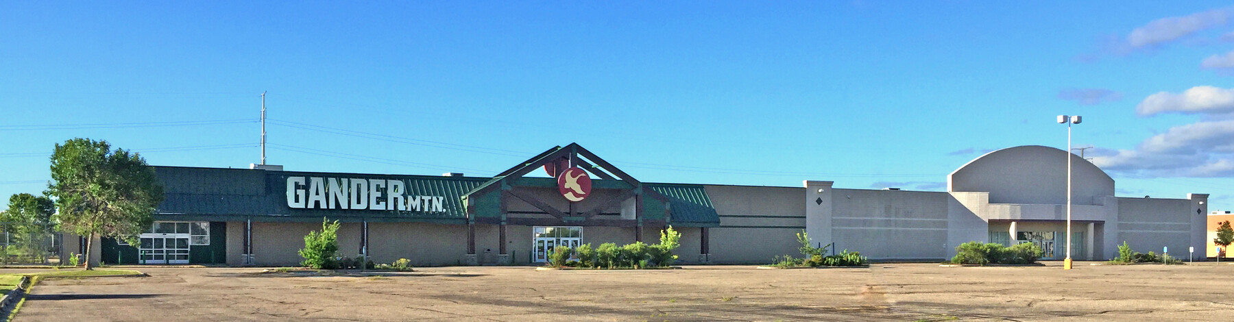
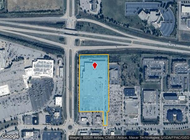
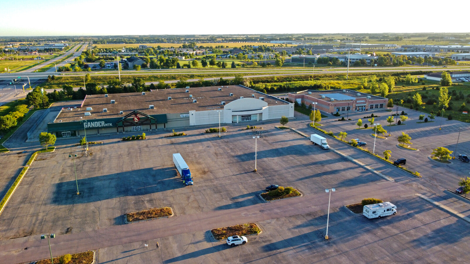
Property Record
1940 Adams St, Mankato, MN 56001

NEARBY LISTINGS FOR SALE OR LEASE
Property Detail
1940 Adams St
Other Market Areas
Haefners First Subdivision
Mankato-North Mankato, MN
HAEFNERS FIRST SUB EXC E170' 004 001 00 013.060A
R01-09-10-301-001
Blue Earth
Storebuilding
Minnesota
2023
4
2023
13.06 AC
170200
East Mankato
117,412 SF
DEMOGRAPHICS near 1940 Adams St
1 Mile
3 Mile
5 Mile
2024 Total Population
2,295
35,472
63,170
2029 Population
2,366
36,406
64,439
Pop Growth 2024-2029
+ 3.09%
+ 2.63%
+ 2.01%
Average Age
39
36
36
2024 Total Households
1,074
14,946
25,124
HH Growth 2024-2029
+ 3.17%
+ 2.73%
+ 2.12%
Median Household Inc
$67,424
$59,836
$65,870
Avg Household Size
2.10
2.20
2.30
2024 Avg HH Vehicles
2.00
2.00
2.00
Median Home Value
$277,714
$217,237
$221,970
Median Year Built
2003
1986
1981
Nearby Places
- Restaurants
- Banks
- Shops
- Fitness
- Groceries
SALE & LEASE HISTORY
LISTING DATE
SALE/LEASE

Sep 02, 2020
For Lease
May 23, 2018
For Sale
Jan 26, 2018
For Lease
Nearby Properties
Address
Land Use
TOTAL SIZE
Lot Size
Zoning
Address
Land Use
TOTAL SIZE
Lot Size
Zoning
4,896 SF
6.31 AC
Address
Land Use
TOTAL SIZE
Lot Size
Zoning
7,920 SF
4.06 AC
Address
Land Use
TOTAL SIZE
Lot Size
Zoning
178,201 SF
64.49 AC
Address
Land Use
TOTAL SIZE
Lot Size
Zoning
191,916 SF
37.68 AC
Address
Land Use
TOTAL SIZE
Lot Size
Zoning
12.37 AC
Address
Land Use
TOTAL SIZE
Lot Size
Zoning
17.90 AC
Address
Land Use
TOTAL SIZE
Lot Size
Zoning
13.43 AC
Address
Land Use
TOTAL SIZE
Lot Size
Zoning
431,029 SF
31.57 AC
Address
Land Use
TOTAL SIZE
Lot Size
Zoning
4,800 SF
138.79 AC
Address
Land Use
TOTAL SIZE
Lot Size
Zoning
11.75 AC
Address
Land Use
TOTAL SIZE
Lot Size
Zoning
287,085 SF
38 AC
Address
Land Use
TOTAL SIZE
Lot Size
Zoning
329,820 SF
18.94 AC
Address
Land Use
TOTAL SIZE
Lot Size
Zoning
331,604 SF
35.88 AC
Address
Land Use
TOTAL SIZE
Lot Size
Zoning
47,274 SF
17.47 AC
Address
Land Use
TOTAL SIZE
Lot Size
Zoning
157,216 SF
31.67 AC
Address
Land Use
TOTAL SIZE
Lot Size
Zoning
4.26 AC
Address
Land Use
TOTAL SIZE
Lot Size
Zoning
137,968 SF
11.96 AC
Address
Land Use
TOTAL SIZE
Lot Size
Zoning
3.73 AC
Address
Land Use
TOTAL SIZE
Lot Size
Zoning
133,550 SF
5.71 AC
Address
Land Use
TOTAL SIZE
Lot Size
Zoning
116,561 SF
3.87 AC
Address
Land Use
TOTAL SIZE
Lot Size
Zoning
91,204 SF
44.54 AC
Address
Land Use
TOTAL SIZE
Lot Size
Zoning
63,880 SF
9.19 AC
Address
Land Use
TOTAL SIZE
Lot Size
Zoning
6.91 AC
Address
Land Use
TOTAL SIZE
Lot Size
Zoning
6.44 AC
Address
Land Use
TOTAL SIZE
Lot Size
Zoning
0.75 AC
Address
Land Use
TOTAL SIZE
Lot Size
Zoning
1,546 SF
2.49 AC
Address
Land Use
TOTAL SIZE
Lot Size
Zoning
94,135 SF
20.82 AC
Address
Land Use
TOTAL SIZE
Lot Size
Zoning
The World's #1 Commercial Real Estate Marketplace
Connect with us
© 2025 CoStar Group
The information above has been obtained from sources believed reliable. While we do not doubt its accuracy we have not verified it and make no guarantee, warranty or representation about it. It is your responsibility to independently confirm its accuracy and completeness. Any projections, opinions, assumptions, or estimates used are for example only and do not represent the current or future performance of the property. The value of this transaction to you depends on tax and other factors which should be evaluated by your tax, financial, and legal advisors. You and your advisors should conduct a careful, independent investigation of the property to determine to your satisfaction the suitability of the property for your needs.