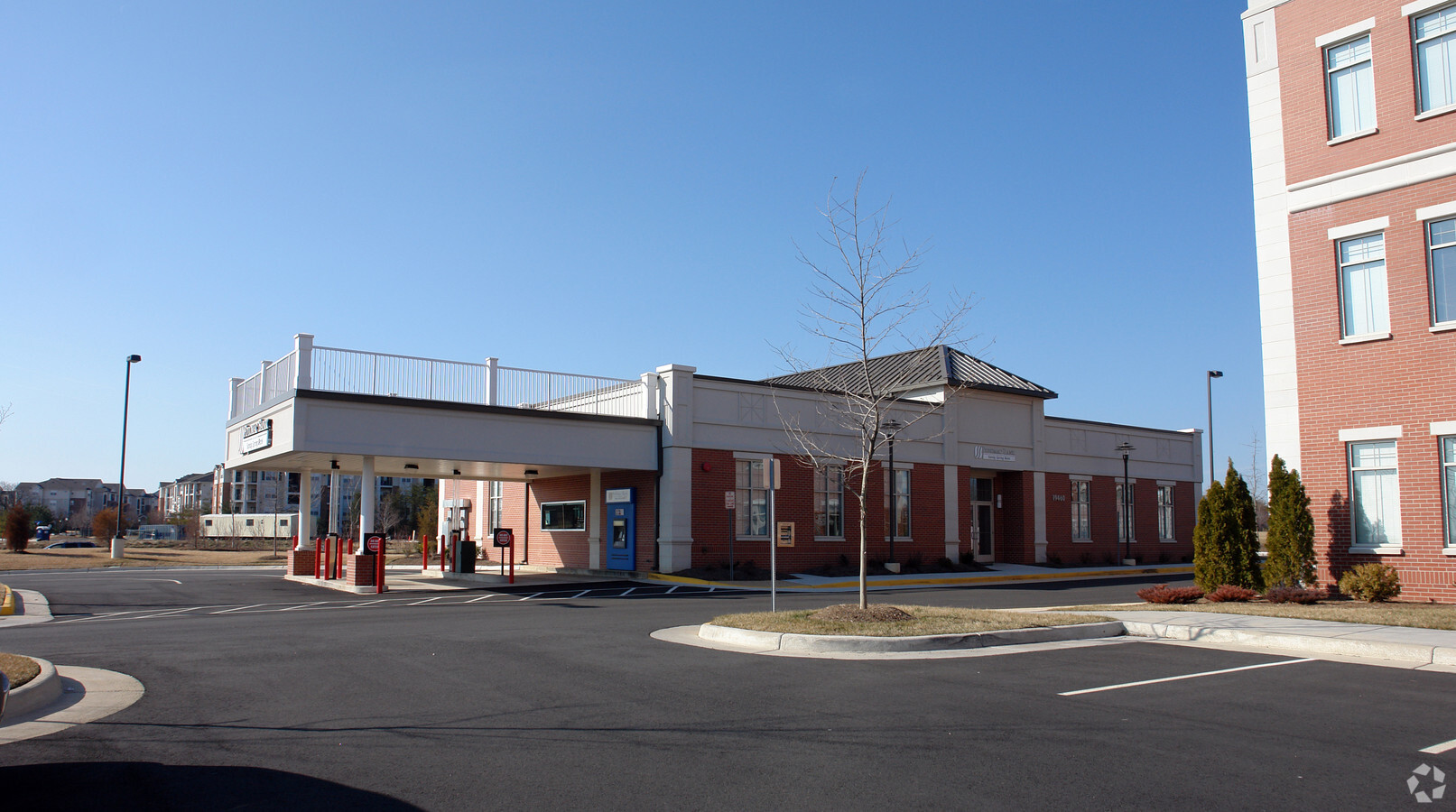
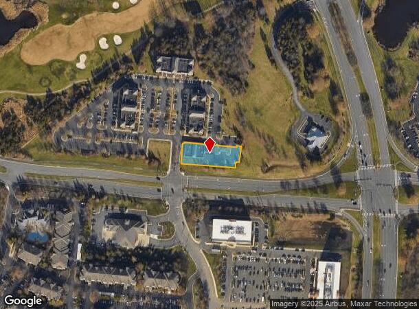
Property Record
19460 Golf Vista Plz, Leesburg, VA 20176

This Property Is For Sale
NEARBY LISTINGS FOR SALE OR LEASE
Property Detail
19460 Golf Vista Plz
082-27-8517
Lansdowne Executive Land Condo
Financialbuilding
LANSDOWNE EXECUTIVE LAND CONDO LAND UNIT 2 200605020038743 200511290133534P
X
Loudoun
51107C0255E
Virginia
2024
0.54 AC
2024
Route 7 Corridor
611009
Washington, DC
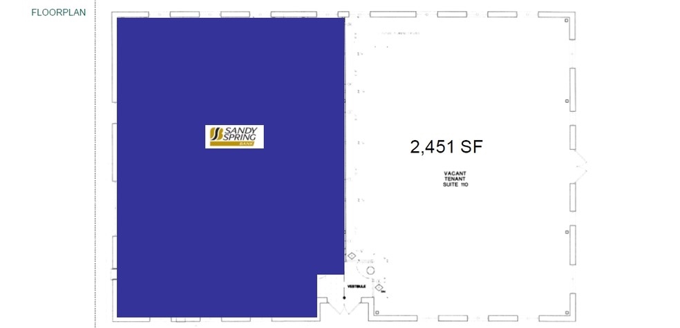
4,902 SF
Washington-Arlington-Alexandria, DC-VA-MD-WV
DEMOGRAPHICS near 19460 Golf Vista Plz
1 Mile
3 Mile
5 Mile
2024 Total Population
10,422
67,187
156,885
2029 Population
11,275
72,497
169,467
Pop Growth 2024-2029
+ 8.18%
+ 7.90%
+ 8.02%
Average Age
44
40
38
2024 Total Households
4,257
24,465
55,320
HH Growth 2024-2029
+ 8.55%
+ 8.22%
+ 8.29%
Median Household Inc
$133,424
$154,211
$140,106
Avg Household Size
2.40
2.70
2.80
2024 Avg HH Vehicles
2.00
2.00
2.00
Median Home Value
$645,997
$697,099
$664,716
Median Year Built
2004
2002
2000
Nearby Places
- Restaurants
- Banks
- Shops
- Fitness
- Groceries
PUBLIC TRANSPORTATION
AIRPORT
Washington Dulles International
DRIVE
WALK
Distance
Washington Dulles International
22 min
12.3 mi
Ronald Reagan Washington Ntl
DRIVE
WALK
Distance
Ronald Reagan Washington Ntl
53 min
33.9 mi
Freight Ports
Port of Baltimore
DRIVE
WALK
Distance
Port of Baltimore
93 min
66.0 mi
Nearby Properties
Address
Land Use
TOTAL SIZE
Lot Size
Zoning
Address
Land Use
TOTAL SIZE
Lot Size
Zoning
684,976 SF
85.31 AC
PDOP
Address
Land Use
TOTAL SIZE
Lot Size
Zoning
1,070,060 SF
197.44 AC
PDRDP
Address
Land Use
TOTAL SIZE
Lot Size
Zoning
481,791 SF
41.28 AC
PDIP
Address
Land Use
TOTAL SIZE
Lot Size
Zoning
414,268 SF
43.68 AC
R16
Address
Land Use
TOTAL SIZE
Lot Size
Zoning
134.40 AC
PDOP
Address
Land Use
TOTAL SIZE
Lot Size
Zoning
341,831 SF
31.21 AC
PDH6
Address
Land Use
TOTAL SIZE
Lot Size
Zoning
420,787 SF
LB:B4
Address
Land Use
TOTAL SIZE
Lot Size
Zoning
274,751 SF
18.87 AC
PDH3
Address
Land Use
TOTAL SIZE
Lot Size
Zoning
430,507 SF
25.60 AC
R16
Address
Land Use
TOTAL SIZE
Lot Size
Zoning
325,665 SF
32.71 AC
PDOP
Address
Land Use
TOTAL SIZE
Lot Size
Zoning
355,228 SF
35 AC
PDSA
Address
Land Use
TOTAL SIZE
Lot Size
Zoning
78.97 AC
PDOP
Address
Land Use
TOTAL SIZE
Lot Size
Zoning
287,479 SF
14.90 AC
PDAAAR
Address
Land Use
TOTAL SIZE
Lot Size
Zoning
213,071 SF
15.57 AC
PDH3
Address
Land Use
TOTAL SIZE
Lot Size
Zoning
199,538 SF
23.35 AC
PDTC
Address
Land Use
TOTAL SIZE
Lot Size
Zoning
260,741 SF
37.30 AC
PDH4
Address
Land Use
TOTAL SIZE
Lot Size
Zoning
190,014 SF
22.23 AC
PDCCSC
Address
Land Use
TOTAL SIZE
Lot Size
Zoning
204,320 SF
10.34 AC
PDRDP
Address
Land Use
TOTAL SIZE
Lot Size
Zoning
103,622 SF
45.07 AC
PDIP
Address
Land Use
TOTAL SIZE
Lot Size
Zoning
247,082 SF
57.50 AC
PDH4
Address
Land Use
TOTAL SIZE
Lot Size
Zoning
240,844 SF
12.11 AC
PDH4
Address
Land Use
TOTAL SIZE
Lot Size
Zoning
100,465 SF
23.38 AC
PDIP
Address
Land Use
TOTAL SIZE
Lot Size
Zoning
129,600 SF
7.48 AC
PDH4
Address
Land Use
TOTAL SIZE
Lot Size
Zoning
156,958 SF
17.63 AC
LB:PRC
Address
Land Use
TOTAL SIZE
Lot Size
Zoning
491,038 SF
PDTRC
Address
Land Use
TOTAL SIZE
Lot Size
Zoning
106.59 AC
PDGI
Address
Land Use
TOTAL SIZE
Lot Size
Zoning
111,040 SF
0.93 AC
PDOP
Address
Land Use
TOTAL SIZE
Lot Size
Zoning
108,204 SF
12.51 AC
PDH4
Address
Land Use
TOTAL SIZE
Lot Size
Zoning
96,637 SF
17.72 AC
PDCCCC
The World's #1 Commercial Real Estate Marketplace
Connect with us
© 2025 CoStar Group
The information above has been obtained from sources believed reliable. While we do not doubt its accuracy we have not verified it and make no guarantee, warranty or representation about it. It is your responsibility to independently confirm its accuracy and completeness. Any projections, opinions, assumptions, or estimates used are for example only and do not represent the current or future performance of the property. The value of this transaction to you depends on tax and other factors which should be evaluated by your tax, financial, and legal advisors. You and your advisors should conduct a careful, independent investigation of the property to determine to your satisfaction the suitability of the property for your needs.