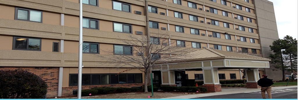
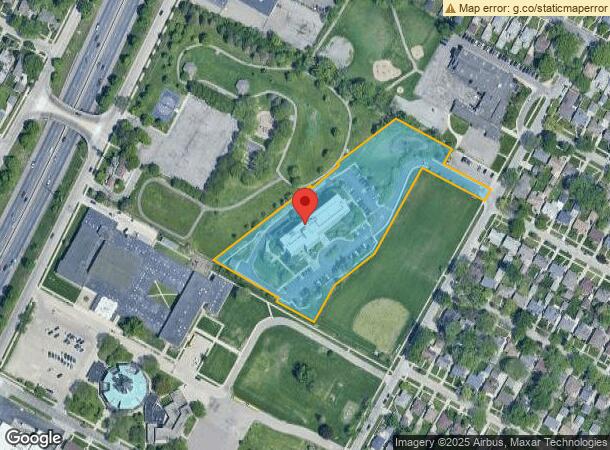
Property Record
19460 Park Dr, Harper Woods, MI 48225
NEARBY LISTINGS FOR SALE OR LEASE
Property Detail
19460 Park Dr
42-003-99-0007-004
618H1A2 J1A2 H2A1A1--J2A2A PT OF PC 618 DESC AS BEG S59DEG 43M 42S E 491.81FT AND N53DEG 26M 37S E 7.94FT FROM INTER OF SLY LINE PC 618 AND ELY R O W LINE OF HARPER AVE 106FT WD TH N53DEG 26M 37S E 354.34FT TH S36DEG 33M 23S E 3.50FT TH N53DEG 26M 37
Retirementnursinghomecombined
Wayne
X
Michigan
26163C0141F
0007
2024
3.74 AC
2024
Grosse Pointe
551300
Detroit
101,095 SF
Detroit-Warren-Dearborn, MI
DEMOGRAPHICS near 19460 Park Dr
1 Mile
3 Mile
5 Mile
2024 Total Population
19,146
148,873
285,608
2029 Population
18,498
146,839
283,750
Pop Growth 2024-2029
(3.38%)
(1.37%)
(0.65%)
Average Age
38
39
39
2024 Total Households
7,301
56,126
110,543
HH Growth 2024-2029
(3.49%)
(1.53%)
(0.79%)
Median Household Inc
$58,963
$56,794
$52,135
Avg Household Size
2.60
2.60
2.50
2024 Avg HH Vehicles
2.00
2.00
2.00
Median Home Value
$151,949
$155,998
$136,787
Median Year Built
1952
1951
1953
Nearby Places
- Restaurants
- Banks
- Shops
- Fitness
- Groceries
PUBLIC TRANSPORTATION
COMMUTER RAIL
Detroit (Wolverine - Amtrak)
DRIVE
WALK
Distance
Detroit (Wolverine - Amtrak)
17 min
9.8 mi
AIRPORT
Windsor International
DRIVE
WALK
Distance
Windsor International
42 min
21.2 mi
Detroit Metro Wayne County
DRIVE
WALK
Distance
Detroit Metro Wayne County
46 min
30.7 mi
Freight Ports
Port of Toledo
DRIVE
WALK
Distance
Port of Toledo
92 min
71.5 mi
Nearby Properties
Address
Land Use
TOTAL SIZE
Lot Size
Zoning
Address
Land Use
TOTAL SIZE
Lot Size
Zoning
1,034,990 SF
28.60 AC
Address
Land Use
TOTAL SIZE
Lot Size
Zoning
211,065 SF
8.84 AC
C.F
Address
Land Use
TOTAL SIZE
Lot Size
Zoning
575,081 SF
8.53 AC
Address
Land Use
TOTAL SIZE
Lot Size
Zoning
182,866 SF
5.08 AC
PD
Address
Land Use
TOTAL SIZE
Lot Size
Zoning
89,970 SF
2.86 AC
RM-1
Address
Land Use
TOTAL SIZE
Lot Size
Zoning
101,733 SF
1.10 AC
C-2
Address
Land Use
TOTAL SIZE
Lot Size
Zoning
103,069 SF
11.41 AC
B-3
Address
Land Use
TOTAL SIZE
Lot Size
Zoning
49,437 SF
0.47 AC
Address
Land Use
TOTAL SIZE
Lot Size
Zoning
93,296 SF
1.05 AC
C-2
Address
Land Use
TOTAL SIZE
Lot Size
Zoning
115,307 SF
7.01 AC
RM-1
Address
Land Use
TOTAL SIZE
Lot Size
Zoning
62,195 SF
1.50 AC
Address
Land Use
TOTAL SIZE
Lot Size
Zoning
75,284 SF
0.87 AC
C
Address
Land Use
TOTAL SIZE
Lot Size
Zoning
41,524 SF
8.81 AC
Address
Land Use
TOTAL SIZE
Lot Size
Zoning
136,270 SF
3.42 AC
LI
Address
Land Use
TOTAL SIZE
Lot Size
Zoning
36,191 SF
3.86 AC
B-2
Address
Land Use
TOTAL SIZE
Lot Size
Zoning
156,352 SF
2.72 AC
MU3
Address
Land Use
TOTAL SIZE
Lot Size
Zoning
46,246 SF
3.19 AC
B-3
Address
Land Use
TOTAL SIZE
Lot Size
Zoning
28,055 SF
0.44 AC
Address
Land Use
TOTAL SIZE
Lot Size
Zoning
30,919 SF
0.86 AC
C
Address
Land Use
TOTAL SIZE
Lot Size
Zoning
92,903 SF
1.70 AC
LI
Address
Land Use
TOTAL SIZE
Lot Size
Zoning
80,320 SF
4.73 AC
RM-1
Address
Land Use
TOTAL SIZE
Lot Size
Zoning
42,113 SF
0.54 AC
Address
Land Use
TOTAL SIZE
Lot Size
Zoning
20,625 SF
0.48 AC
C-2
Address
Land Use
TOTAL SIZE
Lot Size
Zoning
102,205 SF
214.30 AC
Address
Land Use
TOTAL SIZE
Lot Size
Zoning
87,897 SF
4.50 AC
MU2
Address
Land Use
TOTAL SIZE
Lot Size
Zoning
3,312 SF
8.81 AC
R-1A
Address
Land Use
TOTAL SIZE
Lot Size
Zoning
60,694 SF
3.04 AC
B-2
Address
Land Use
TOTAL SIZE
Lot Size
Zoning
92,610 SF
1.76 AC
MU3
Address
Land Use
TOTAL SIZE
Lot Size
Zoning
49,807 SF
0.84 AC
PD
Address
Land Use
TOTAL SIZE
Lot Size
Zoning
10,908 SF
2.78 AC
MU3
The World's #1 Commercial Real Estate Marketplace
Connect with us
© 2025 CoStar Group
The information above has been obtained from sources believed reliable. While we do not doubt its accuracy we have not verified it and make no guarantee, warranty or representation about it. It is your responsibility to independently confirm its accuracy and completeness. Any projections, opinions, assumptions, or estimates used are for example only and do not represent the current or future performance of the property. The value of this transaction to you depends on tax and other factors which should be evaluated by your tax, financial, and legal advisors. You and your advisors should conduct a careful, independent investigation of the property to determine to your satisfaction the suitability of the property for your needs.