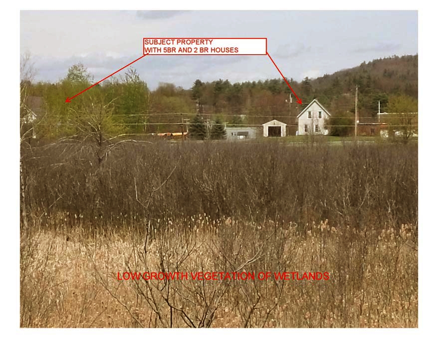
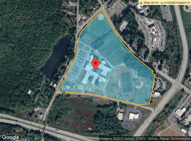
Property Record
195 Hanover St, Lebanon, NH 03766
NEARBY LISTINGS FOR SALE OR LEASE
Property Detail
195 Hanover St
LBAN-000064-000033
Grafton
Publicschool
New Hampshire
X
37.58 AC
33009C0894E
Concord/New Hampshire North Area
0
Other Market Areas
2024
Claremont-Lebanon, NH-VT
961701
DEMOGRAPHICS near 195 Hanover St
1 Mile
3 Mile
5 Mile
2024 Total Population
5,496
14,386
31,249
2029 Population
5,850
15,207
32,534
Pop Growth 2024-2029
+ 6.44%
+ 5.71%
+ 4.11%
Average Age
42
42
40
2024 Total Households
2,798
6,811
13,139
HH Growth 2024-2029
+ 6.33%
+ 5.59%
+ 4.27%
Median Household Inc
$88,569
$92,763
$90,808
Avg Household Size
1.90
2.00
2.10
2024 Avg HH Vehicles
1.00
2.00
2.00
Median Home Value
$251,718
$315,364
$320,713
Median Year Built
1982
1981
1978
Nearby Places
- Restaurants
- Banks
- Shops
- Fitness
- Groceries
PUBLIC TRANSPORTATION
COMMUTER RAIL
White River Junction Amtrak Station (Vermonter - Amtrak)
DRIVE
WALK
Distance
White River Junction Amtrak Station (Vermonter - Amtrak)
13 min
5.6 mi
Freight Ports
Portland, ME
DRIVE
WALK
Distance
Portland, ME
195 min
163.4 mi
Nearby Properties
Address
Land Use
TOTAL SIZE
Lot Size
Zoning
Address
Land Use
TOTAL SIZE
Lot Size
Zoning
163,845 SF
MC
Address
Land Use
TOTAL SIZE
Lot Size
Zoning
3,136 SF
53.32 AC
R1
Address
Land Use
TOTAL SIZE
Lot Size
Zoning
137,168 SF
11.39 AC
GC
Address
Land Use
TOTAL SIZE
Lot Size
Zoning
3.76 AC
GC
Address
Land Use
TOTAL SIZE
Lot Size
Zoning
1,315 SF
16.35 AC
RL3
Address
Land Use
TOTAL SIZE
Lot Size
Zoning
356.40 AC
RL3
Address
Land Use
TOTAL SIZE
Lot Size
Zoning
191,951 SF
17.70 AC
R1
Address
Land Use
TOTAL SIZE
Lot Size
Zoning
18.38 AC
R3
Address
Land Use
TOTAL SIZE
Lot Size
Zoning
202,868 SF
5.74 AC
LD
Address
Land Use
TOTAL SIZE
Lot Size
Zoning
10.20 AC
R3
Address
Land Use
TOTAL SIZE
Lot Size
Zoning
106,069 SF
19.42 AC
R3
Address
Land Use
TOTAL SIZE
Lot Size
Zoning
23.33 AC
R3
Address
Land Use
TOTAL SIZE
Lot Size
Zoning
169.73 AC
MC
Address
Land Use
TOTAL SIZE
Lot Size
Zoning
128,514 SF
11.10 AC
R1
Address
Land Use
TOTAL SIZE
Lot Size
Zoning
146,472 SF
23.24 AC
INDL
Address
Land Use
TOTAL SIZE
Lot Size
Zoning
81,160 SF
2.61 AC
INDL
Address
Land Use
TOTAL SIZE
Lot Size
Zoning
116.22 AC
MC
Address
Land Use
TOTAL SIZE
Lot Size
Zoning
78,986 SF
3.71 AC
INDL
Address
Land Use
TOTAL SIZE
Lot Size
Zoning
75,077 SF
8.97 AC
INDL
Address
Land Use
TOTAL SIZE
Lot Size
Zoning
11.38 AC
MC
Address
Land Use
TOTAL SIZE
Lot Size
Zoning
10.74 AC
INDL
Address
Land Use
TOTAL SIZE
Lot Size
Zoning
74,917 SF
7.97 AC
INDL
Address
Land Use
TOTAL SIZE
Lot Size
Zoning
26.70 AC
INDL
Address
Land Use
TOTAL SIZE
Lot Size
Zoning
54.48 AC
R3
Address
Land Use
TOTAL SIZE
Lot Size
Zoning
49,866 SF
7.42 AC
INDL
Address
Land Use
TOTAL SIZE
Lot Size
Zoning
55,677 SF
2.10 AC
INDL
Address
Land Use
TOTAL SIZE
Lot Size
Zoning
11.23 AC
GC
Address
Land Use
TOTAL SIZE
Lot Size
Zoning
65,576 SF
5.67 AC
INDL
Address
Land Use
TOTAL SIZE
Lot Size
Zoning
64,431 SF
4.97 AC
INDL
The World's #1 Commercial Real Estate Marketplace
Connect with us
© 2025 CoStar Group
The information above has been obtained from sources believed reliable. While we do not doubt its accuracy we have not verified it and make no guarantee, warranty or representation about it. It is your responsibility to independently confirm its accuracy and completeness. Any projections, opinions, assumptions, or estimates used are for example only and do not represent the current or future performance of the property. The value of this transaction to you depends on tax and other factors which should be evaluated by your tax, financial, and legal advisors. You and your advisors should conduct a careful, independent investigation of the property to determine to your satisfaction the suitability of the property for your needs.