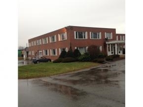
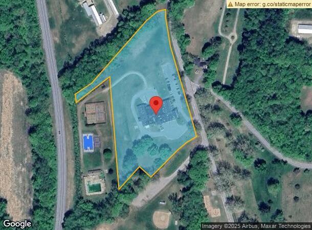
Property Record
195 Main St, Walpole, NH 03608
NEARBY LISTINGS FOR SALE OR LEASE
-
-
View all Walpole listings for sale on LoopNet.com
Property Detail
195 Main St
WLPO-000022-000000-000005
Cheshire
Commercialbuilding
New Hampshire
X
5
50025C0258E
7.15 AC
2024
Manchester/New Hampshire South Area
2024
Other Market Areas
970200
Keene, NH
25,902 SF
DEMOGRAPHICS near 195 Main St
1 Mile
3 Mile
5 Mile
2024 Total Population
516
3,700
9,133
2029 Population
516
3,697
9,244
Pop Growth 2024-2029
0.00%
(0.08%)
+ 1.22%
Average Age
48
46
45
2024 Total Households
239
1,668
4,068
HH Growth 2024-2029
(0.42%)
(0.30%)
+ 0.98%
Median Household Inc
$73,557
$70,815
$69,526
Avg Household Size
2.10
2.20
2.20
2024 Avg HH Vehicles
2.00
2.00
2.00
Median Home Value
$323,585
$253,806
$230,842
Median Year Built
1962
1959
1961
Nearby Places
- Restaurants
- Banks
- Shops
- Fitness
- Groceries
PUBLIC TRANSPORTATION
COMMUTER RAIL
Bellows Falls Amtrak Station (Vermonter - Amtrak)
DRIVE
WALK
Distance
Bellows Falls Amtrak Station (Vermonter - Amtrak)
10 min
4.5 mi
Freight Ports
Albany, NY Port
DRIVE
WALK
Distance
Albany, NY Port
159 min
103.7 mi
SALE & LEASE HISTORY
LISTING DATE
SALE/LEASE

Sep 24, 2016
For Sale
Nov 01, 2017
For Sale
Apr 17, 2017
For Sale
Nearby Properties
Address
Land Use
TOTAL SIZE
Lot Size
Zoning
Address
Land Use
TOTAL SIZE
Lot Size
Zoning
8.30 AC
Address
Land Use
TOTAL SIZE
Lot Size
Zoning
12.70 AC
Address
Land Use
TOTAL SIZE
Lot Size
Zoning
Address
Land Use
TOTAL SIZE
Lot Size
Zoning
16.54 AC
RB R
Address
Land Use
TOTAL SIZE
Lot Size
Zoning
50.80 AC
Address
Land Use
TOTAL SIZE
Lot Size
Zoning
55,042 SF
12.15 AC
COM C
Address
Land Use
TOTAL SIZE
Lot Size
Zoning
Address
Land Use
TOTAL SIZE
Lot Size
Zoning
28,905 SF
5.85 AC
Address
Land Use
TOTAL SIZE
Lot Size
Zoning
1.90 AC
RB R
Address
Land Use
TOTAL SIZE
Lot Size
Zoning
176 AC
IND I
Address
Land Use
TOTAL SIZE
Lot Size
Zoning
19,452 SF
4.92 AC
COM C
Address
Land Use
TOTAL SIZE
Lot Size
Zoning
31,343 SF
3.34 AC
COM C
Address
Land Use
TOTAL SIZE
Lot Size
Zoning
Address
Land Use
TOTAL SIZE
Lot Size
Zoning
4.04 AC
COM C
Address
Land Use
TOTAL SIZE
Lot Size
Zoning
9,891 SF
5.10 AC
RUR R
Address
Land Use
TOTAL SIZE
Lot Size
Zoning
8.80 AC
Address
Land Use
TOTAL SIZE
Lot Size
Zoning
Address
Land Use
TOTAL SIZE
Lot Size
Zoning
20,063 SF
4.39 AC
RUR R
Address
Land Use
TOTAL SIZE
Lot Size
Zoning
12,854 SF
0.27 AC
RB R
Address
Land Use
TOTAL SIZE
Lot Size
Zoning
23,079 SF
0.71 AC
COM C
Address
Land Use
TOTAL SIZE
Lot Size
Zoning
5.94 AC
COM C
Address
Land Use
TOTAL SIZE
Lot Size
Zoning
12,565 SF
4.76 AC
COM C
Address
Land Use
TOTAL SIZE
Lot Size
Zoning
15,852 SF
4.10 AC
COM C
Address
Land Use
TOTAL SIZE
Lot Size
Zoning
56 AC
RUR R
Address
Land Use
TOTAL SIZE
Lot Size
Zoning
10,981 SF
1.78 AC
COM C
Address
Land Use
TOTAL SIZE
Lot Size
Zoning
23,184 SF
5.04 AC
COM C
Address
Land Use
TOTAL SIZE
Lot Size
Zoning
1.20 AC
Address
Land Use
TOTAL SIZE
Lot Size
Zoning
11,494 SF
8.66 AC
COM C
Address
Land Use
TOTAL SIZE
Lot Size
Zoning
8,549 SF
1.30 AC
COM C
The World's #1 Commercial Real Estate Marketplace
Connect with us
© 2025 CoStar Group
The information above has been obtained from sources believed reliable. While we do not doubt its accuracy we have not verified it and make no guarantee, warranty or representation about it. It is your responsibility to independently confirm its accuracy and completeness. Any projections, opinions, assumptions, or estimates used are for example only and do not represent the current or future performance of the property. The value of this transaction to you depends on tax and other factors which should be evaluated by your tax, financial, and legal advisors. You and your advisors should conduct a careful, independent investigation of the property to determine to your satisfaction the suitability of the property for your needs.