Property Record
1941 S White Mountain Rd, Show Low, AZ 85901
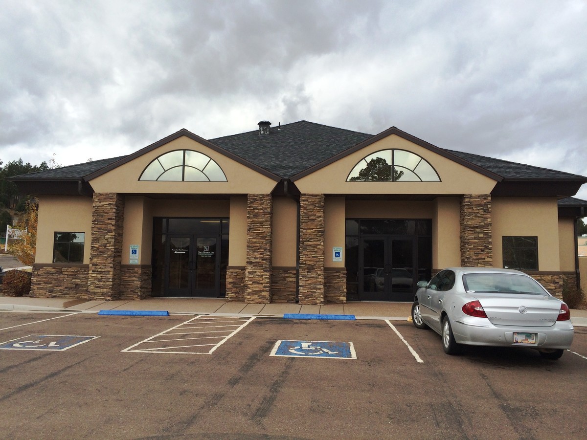
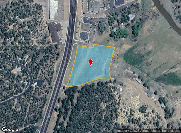
This Property Is For Sale
Current Lease Availabilities
NEARBY LISTINGS FOR SALE OR LEASE
Property Detail
1941 S White Mountain Rd
Show Low, AZ
To Meadow
210-32-016T
SECTION 29, T10N,R22E: COM E4 COR SEC 29; TH S00*3347 W 1220.10 TPOB; TH S00*0642 E 93.67; TH S20*1331 W 296.73; TH S01*593 3 E 109.47; TH S04*4553 E 35.52; TH S77*0151 W 184.85; TH S6 8*4641 W 60.10; TH S84*5726 W 201.27; TH ALG A CURVE (R=2644. 42)
Commercialacreage
Navajo
X
Arizona
04017C4707F
4.21 AC
2023
Arizona Northeast & Holbrook Area
2025
Other Market Areas
961701
DEMOGRAPHICS near 1941 S White Mountain Rd
1 Mile
3 Mile
5 Mile
2024 Total Population
1,765
14,279
22,215
2029 Population
1,909
15,541
24,267
Pop Growth 2024-2029
+ 8.16%
+ 8.84%
+ 9.24%
Average Age
43
42
44
2024 Total Households
760
5,733
9,001
HH Growth 2024-2029
+ 7.89%
+ 8.77%
+ 9.23%
Median Household Inc
$73,653
$56,155
$56,642
Avg Household Size
2.30
2.40
2.40
2024 Avg HH Vehicles
2.00
2.00
2.00
Median Home Value
$401,862
$221,685
$237,659
Median Year Built
2002
1997
1997
Nearby Places
- Restaurants
- Banks
- Shops
- Fitness
- Groceries
Nearby Properties
Address
Land Use
TOTAL SIZE
Lot Size
Zoning
Address
Land Use
TOTAL SIZE
Lot Size
Zoning
203,623 SF
14 AC
MUNICIPAL
Address
Land Use
TOTAL SIZE
Lot Size
Zoning
174.30 AC
MUNICIPAL
Address
Land Use
TOTAL SIZE
Lot Size
Zoning
147,745 SF
12.70 AC
MUNICIPAL
Address
Land Use
TOTAL SIZE
Lot Size
Zoning
74,338 SF
2.29 AC
Address
Land Use
TOTAL SIZE
Lot Size
Zoning
55,688 SF
1.50 AC
C-R
Address
Land Use
TOTAL SIZE
Lot Size
Zoning
56,096 SF
1.48 AC
C-R
Address
Land Use
TOTAL SIZE
Lot Size
Zoning
97,790 SF
4.80 AC
MUNICIPAL
Address
Land Use
TOTAL SIZE
Lot Size
Zoning
86,443 SF
6.85 AC
MUNICIPAL
Address
Land Use
TOTAL SIZE
Lot Size
Zoning
55,237 SF
6.03 AC
MUNICIPAL
Address
Land Use
TOTAL SIZE
Lot Size
Zoning
56,331 SF
16.30 AC
MUNICIPAL
Address
Land Use
TOTAL SIZE
Lot Size
Zoning
30,952 SF
5.72 AC
MUNICIPAL
Address
Land Use
TOTAL SIZE
Lot Size
Zoning
81,647 SF
4.47 AC
MUNICIPAL
Address
Land Use
TOTAL SIZE
Lot Size
Zoning
83,087 SF
5.08 AC
MUNICIPAL
Address
Land Use
TOTAL SIZE
Lot Size
Zoning
30,942 SF
3.21 AC
MUNICIPAL
Address
Land Use
TOTAL SIZE
Lot Size
Zoning
46,700 SF
2.51 AC
MUNICIPAL
Address
Land Use
TOTAL SIZE
Lot Size
Zoning
56,032 SF
4.60 AC
MUNICIPAL
Address
Land Use
TOTAL SIZE
Lot Size
Zoning
22,400 SF
2.55 AC
MUNICIPAL
Address
Land Use
TOTAL SIZE
Lot Size
Zoning
29,707 SF
3 AC
MUNICIPAL
Address
Land Use
TOTAL SIZE
Lot Size
Zoning
76,060 SF
4.69 AC
MUNICIPAL
Address
Land Use
TOTAL SIZE
Lot Size
Zoning
47,586 SF
3.50 AC
MUNICIPAL
Address
Land Use
TOTAL SIZE
Lot Size
Zoning
24,000 SF
4.09 AC
MUNICIPAL
Address
Land Use
TOTAL SIZE
Lot Size
Zoning
16,349 SF
3.68 AC
MUNICIPAL
Address
Land Use
TOTAL SIZE
Lot Size
Zoning
26,513 SF
9.76 AC
MUNICIPAL
Address
Land Use
TOTAL SIZE
Lot Size
Zoning
18,000 SF
2.09 AC
MUNICIPAL
Address
Land Use
TOTAL SIZE
Lot Size
Zoning
17,948 SF
3.31 AC
MUNICIPAL
Address
Land Use
TOTAL SIZE
Lot Size
Zoning
22,705 SF
3.74 AC
MUNICIPAL
Address
Land Use
TOTAL SIZE
Lot Size
Zoning
31,443 SF
1.96 AC
MUNICIPAL
Address
Land Use
TOTAL SIZE
Lot Size
Zoning
7,328 SF
1.82 AC
MUNICIPAL
Address
Land Use
TOTAL SIZE
Lot Size
Zoning
15,073 SF
3.36 AC
MUNICIPAL
Address
Land Use
TOTAL SIZE
Lot Size
Zoning
90,509 SF
5.78 AC
The World's #1 Commercial Real Estate Marketplace
Connect with us
© 2025 CoStar Group
The information above has been obtained from sources believed reliable. While we do not doubt its accuracy we have not verified it and make no guarantee, warranty or representation about it. It is your responsibility to independently confirm its accuracy and completeness. Any projections, opinions, assumptions, or estimates used are for example only and do not represent the current or future performance of the property. The value of this transaction to you depends on tax and other factors which should be evaluated by your tax, financial, and legal advisors. You and your advisors should conduct a careful, independent investigation of the property to determine to your satisfaction the suitability of the property for your needs.