Property Record
19551 Plymouth Rd, Detroit, MI 48228
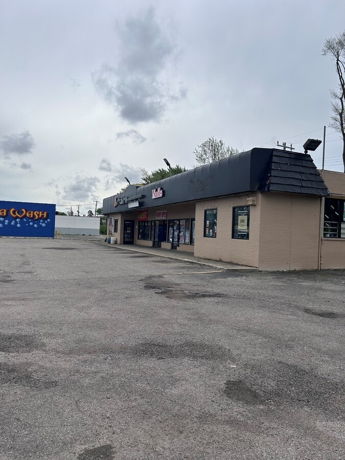

This Property Is For Sale
NEARBY LISTINGS FOR SALE OR LEASE
Property Detail
19551 Plymouth Rd
22-0053819
Grove Park Sub
Storebuilding
S PLYMOUTH 848 THRU 856 PALMER GROVE PARK SUB NO 2 L56 P42 PLATS, W C R 22/316 185 X 100
X
Wayne
26163C0255E
Michigan
2024
0.42 AC
2024
Detroit W of Woodward
547100
Detroit
2,560 SF
Detroit-Warren-Dearborn, MI
DEMOGRAPHICS near 19551 Plymouth Rd
1 Mile
3 Mile
5 Mile
2024 Total Population
13,763
141,895
392,265
2029 Population
13,633
139,503
382,941
Pop Growth 2024-2029
(0.94%)
(1.69%)
(2.38%)
Average Age
36
36
37
2024 Total Households
5,330
52,380
145,459
HH Growth 2024-2029
(1.16%)
(1.74%)
(2.36%)
Median Household Inc
$37,896
$38,737
$43,491
Avg Household Size
2.50
2.60
2.60
2024 Avg HH Vehicles
1.00
1.00
1.00
Median Home Value
$56,027
$83,931
$116,703
Median Year Built
1952
1951
1952
Nearby Places
- Restaurants
- Banks
- Shops
- Fitness
- Groceries
PUBLIC TRANSPORTATION
COMMUTER RAIL
Dearborn (Wolverine - Amtrak)
DRIVE
WALK
Distance
Dearborn (Wolverine - Amtrak)
11 min
6.3 mi
AIRPORT
Detroit Metro Wayne County
DRIVE
WALK
Distance
Detroit Metro Wayne County
30 min
18.9 mi
Windsor International
DRIVE
WALK
Distance
Windsor International
40 min
22.1 mi
Freight Ports
Port of Toledo
DRIVE
WALK
Distance
Port of Toledo
79 min
61.0 mi
Nearby Properties
Address
Land Use
TOTAL SIZE
Lot Size
Zoning
Address
Land Use
TOTAL SIZE
Lot Size
Zoning
335,133 SF
22.08 AC
Address
Land Use
TOTAL SIZE
Lot Size
Zoning
515,664 SF
48.94 AC
M4
Address
Land Use
TOTAL SIZE
Lot Size
Zoning
85.45 AC
Address
Land Use
TOTAL SIZE
Lot Size
Zoning
300,936 SF
18.40 AC
M4
Address
Land Use
TOTAL SIZE
Lot Size
Zoning
261,917 SF
9.31 AC
PD
Address
Land Use
TOTAL SIZE
Lot Size
Zoning
192,813 SF
28.92 AC
TR
Address
Land Use
TOTAL SIZE
Lot Size
Zoning
145,702 SF
16.35 AC
TR
Address
Land Use
TOTAL SIZE
Lot Size
Zoning
486,416 SF
19.95 AC
M4
Address
Land Use
TOTAL SIZE
Lot Size
Zoning
835,383 SF
36.85 AC
Address
Land Use
TOTAL SIZE
Lot Size
Zoning
72,326 SF
0.74 AC
Address
Land Use
TOTAL SIZE
Lot Size
Zoning
158,354 SF
43.70 AC
M4
Address
Land Use
TOTAL SIZE
Lot Size
Zoning
207,081 SF
8.80 AC
B5
Address
Land Use
TOTAL SIZE
Lot Size
Zoning
113,515 SF
12.90 AC
BB
Address
Land Use
TOTAL SIZE
Lot Size
Zoning
167,562 SF
9.25 AC
R5
Address
Land Use
TOTAL SIZE
Lot Size
Zoning
83,594 SF
3.49 AC
BB
Address
Land Use
TOTAL SIZE
Lot Size
Zoning
179,412 SF
2.17 AC
Address
Land Use
TOTAL SIZE
Lot Size
Zoning
129,975 SF
6.89 AC
R5
Address
Land Use
TOTAL SIZE
Lot Size
Zoning
63,924 SF
0.60 AC
Address
Land Use
TOTAL SIZE
Lot Size
Zoning
113,451 SF
3.94 AC
RE
Address
Land Use
TOTAL SIZE
Lot Size
Zoning
153,517 SF
5.02 AC
Address
Land Use
TOTAL SIZE
Lot Size
Zoning
125,576 SF
5.56 AC
PD
Address
Land Use
TOTAL SIZE
Lot Size
Zoning
52.57 AC
Address
Land Use
TOTAL SIZE
Lot Size
Zoning
79,831 SF
7.60 AC
B3
Address
Land Use
TOTAL SIZE
Lot Size
Zoning
402,213 SF
16.50 AC
M3
Address
Land Use
TOTAL SIZE
Lot Size
Zoning
331,590 SF
18.50 AC
M4
Address
Land Use
TOTAL SIZE
Lot Size
Zoning
97,114 SF
2.10 AC
R1
Address
Land Use
TOTAL SIZE
Lot Size
Zoning
315,973 SF
12.18 AC
M4
Address
Land Use
TOTAL SIZE
Lot Size
Zoning
95,908 SF
1.12 AC
Address
Land Use
TOTAL SIZE
Lot Size
Zoning
140,199 SF
11.36 AC
BB
Address
Land Use
TOTAL SIZE
Lot Size
Zoning
207,088 SF
14.25 AC
R-1
The World's #1 Commercial Real Estate Marketplace
Connect with us
© 2025 CoStar Group
The information above has been obtained from sources believed reliable. While we do not doubt its accuracy we have not verified it and make no guarantee, warranty or representation about it. It is your responsibility to independently confirm its accuracy and completeness. Any projections, opinions, assumptions, or estimates used are for example only and do not represent the current or future performance of the property. The value of this transaction to you depends on tax and other factors which should be evaluated by your tax, financial, and legal advisors. You and your advisors should conduct a careful, independent investigation of the property to determine to your satisfaction the suitability of the property for your needs.