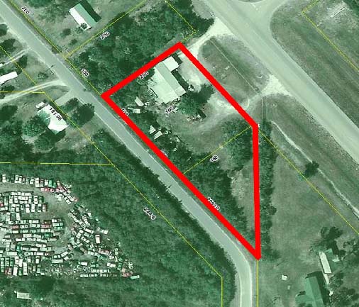
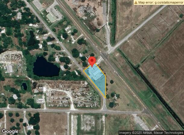
Property Record
1963 Us Highway 98 N, Okeechobee, FL 34972
NEARBY LISTINGS FOR SALE OR LEASE
Property Detail
1963 Us Highway 98 N
Okeechobee, FL
Playland Park Acres
R1-07-37-35-0A00-00035-A000
LOTS 18, 19 AND 19-A OF PLAYLAND PARK ACRES, ACCORDING TO THE SURVEY THEREOF RECORDED IN OFFICIAL RECORDS BOOK 145, PAGE 984, AND IN OFFICIAL RECORDS BOOK 191, PAGE 105, PUBLIC RECORDS OF OKEECHOBEE COUNTY, FLORIDA, BEING MORE PARTICULARLY DESCRIBED
Warehouse
Okeechobee
A
Florida
12093C0415C
18,19
2023
1.12 AC
2023
Florida Central South Area
910202
Other Market Areas
5,415 SF
DEMOGRAPHICS near 1963 Us Highway 98 N
1 Mile
3 Mile
5 Mile
2024 Total Population
2,200
12,659
23,408
2029 Population
2,291
13,325
24,894
Pop Growth 2024-2029
+ 4.14%
+ 5.26%
+ 6.35%
Average Age
34
38
41
2024 Total Households
638
4,360
8,604
HH Growth 2024-2029
+ 4.23%
+ 5.55%
+ 6.93%
Median Household Inc
$64,342
$52,623
$50,208
Avg Household Size
3.20
2.80
2.60
2024 Avg HH Vehicles
2.00
2.00
2.00
Median Home Value
$137,142
$146,609
$145,217
Median Year Built
1980
1983
1986
Nearby Places
- Restaurants
- Banks
- Shops
- Fitness
- Groceries
PUBLIC TRANSPORTATION
COMMUTER RAIL
Okeechobee Amtrak (Silver Star - Amtrak)
DRIVE
WALK
Distance
Okeechobee Amtrak (Silver Star - Amtrak)
5 min
2.3 mi
Freight Ports
Port of Palm Beach
DRIVE
WALK
Distance
Port of Palm Beach
91 min
62.1 mi
Nearby Properties
Address
Land Use
TOTAL SIZE
Lot Size
Zoning
Address
Land Use
TOTAL SIZE
Lot Size
Zoning
184,936 SF
49.13 AC
Address
Land Use
TOTAL SIZE
Lot Size
Zoning
130,899 SF
11.02 AC
Address
Land Use
TOTAL SIZE
Lot Size
Zoning
74,541 SF
110.96 AC
Address
Land Use
TOTAL SIZE
Lot Size
Zoning
97,756 SF
4.13 AC
Address
Land Use
TOTAL SIZE
Lot Size
Zoning
96,720 SF
14.79 AC
Address
Land Use
TOTAL SIZE
Lot Size
Zoning
98,005 SF
30.43 AC
Address
Land Use
TOTAL SIZE
Lot Size
Zoning
78,284 SF
7.98 AC
Address
Land Use
TOTAL SIZE
Lot Size
Zoning
91,700 SF
20.56 AC
Address
Land Use
TOTAL SIZE
Lot Size
Zoning
6,372 SF
21 AC
Address
Land Use
TOTAL SIZE
Lot Size
Zoning
86,516 SF
15.30 AC
Address
Land Use
TOTAL SIZE
Lot Size
Zoning
78,339 SF
10.74 AC
Address
Land Use
TOTAL SIZE
Lot Size
Zoning
46,330 SF
41 AC
Address
Land Use
TOTAL SIZE
Lot Size
Zoning
19,768 SF
8 AC
Address
Land Use
TOTAL SIZE
Lot Size
Zoning
2,199 SF
258.06 AC
Address
Land Use
TOTAL SIZE
Lot Size
Zoning
47,304 SF
9.90 AC
Address
Land Use
TOTAL SIZE
Lot Size
Zoning
60,818 SF
7.76 AC
Address
Land Use
TOTAL SIZE
Lot Size
Zoning
775 SF
23.86 AC
Address
Land Use
TOTAL SIZE
Lot Size
Zoning
9,615 SF
7.38 AC
Address
Land Use
TOTAL SIZE
Lot Size
Zoning
9,803 SF
38.65 AC
Address
Land Use
TOTAL SIZE
Lot Size
Zoning
58,580 SF
10.82 AC
Address
Land Use
TOTAL SIZE
Lot Size
Zoning
1,656 SF
176 AC
Address
Land Use
TOTAL SIZE
Lot Size
Zoning
25,746 SF
28.50 AC
Address
Land Use
TOTAL SIZE
Lot Size
Zoning
62,944 SF
5.48 AC
Address
Land Use
TOTAL SIZE
Lot Size
Zoning
26,572 SF
1.08 AC
Address
Land Use
TOTAL SIZE
Lot Size
Zoning
39,352 SF
1.94 AC
Address
Land Use
TOTAL SIZE
Lot Size
Zoning
35,088 SF
7.50 AC
Address
Land Use
TOTAL SIZE
Lot Size
Zoning
44,852 SF
11.59 AC
Address
Land Use
TOTAL SIZE
Lot Size
Zoning
5,142 SF
0.32 AC
Address
Land Use
TOTAL SIZE
Lot Size
Zoning
14,094 SF
2.05 AC
Address
Land Use
TOTAL SIZE
Lot Size
Zoning
21,530 SF
3.14 AC
The World's #1 Commercial Real Estate Marketplace
Connect with us
© 2025 CoStar Group
The information above has been obtained from sources believed reliable. While we do not doubt its accuracy we have not verified it and make no guarantee, warranty or representation about it. It is your responsibility to independently confirm its accuracy and completeness. Any projections, opinions, assumptions, or estimates used are for example only and do not represent the current or future performance of the property. The value of this transaction to you depends on tax and other factors which should be evaluated by your tax, financial, and legal advisors. You and your advisors should conduct a careful, independent investigation of the property to determine to your satisfaction the suitability of the property for your needs.