Property Record
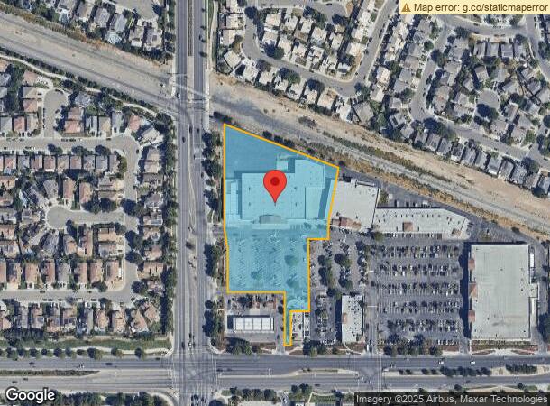
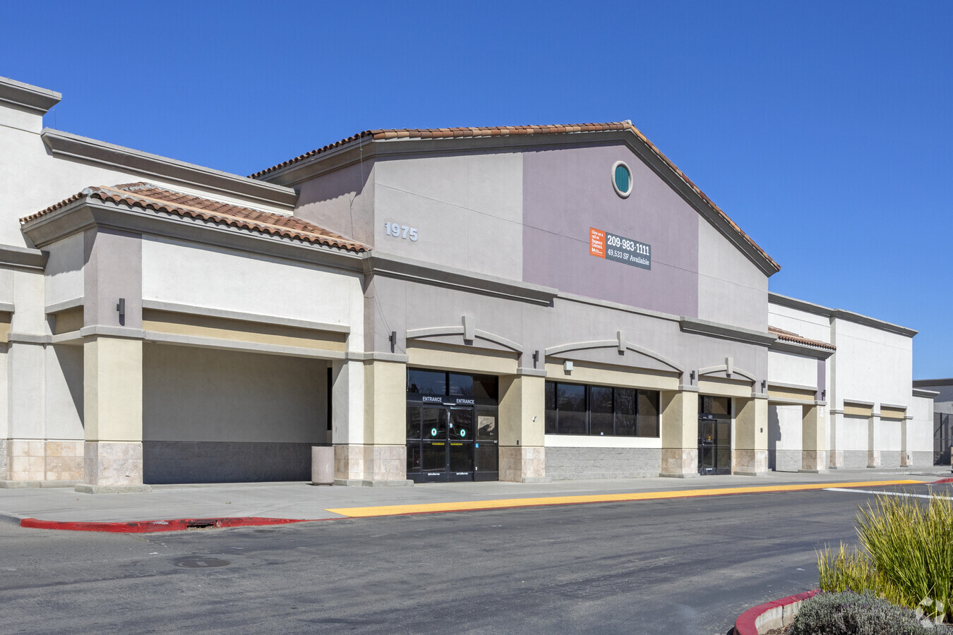
1975 W 11Th St, Tracy, CA 95376

NEARBY LISTINGS FOR SALE OR LEASE
Property Detail
1975 W 11Th St
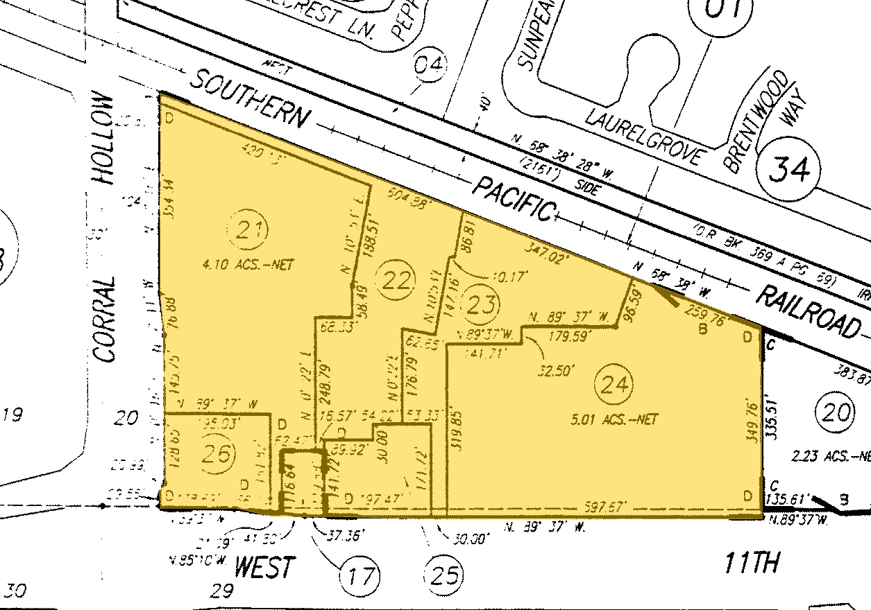
232-170-21
03-FM PT 18/PT TO 22-26/P.M. 22-79
Regionalshoppingcenterormallwithanchorstore
San Joaquin
X
California
06077C0730F
4.10 AC
2024
Tracy/Manteca
2024
Stockton/Modesto
005308
Stockton-Lodi, CA
50,222 SF
DEMOGRAPHICS near 1975 W 11Th St
1 Mile
3 Mile
5 Mile
2024 Total Population
24,207
90,510
106,407
2029 Population
25,479
95,561
112,554
Pop Growth 2024-2029
+ 5.25%
+ 5.58%
+ 5.78%
Average Age
38
37
37
2024 Total Households
6,954
27,111
31,711
HH Growth 2024-2029
+ 5.21%
+ 5.58%
+ 5.79%
Median Household Inc
$112,047
$106,568
$111,824
Avg Household Size
3.40
3.30
3.30
2024 Avg HH Vehicles
3.00
3.00
3.00
Median Home Value
$634,123
$616,386
$646,232
Median Year Built
1993
1992
1995
Nearby Places
- Restaurants
- Banks
- Shops
- Fitness
- Groceries
PUBLIC TRANSPORTATION
COMMUTER RAIL
Tracy (Altamont Corridor Express - Altamont Commuter Express (ACE))
DRIVE
WALK
Distance
Tracy (Altamont Corridor Express - Altamont Commuter Express (ACE))
7 min
4.1 mi
AIRPORT
Stockton Metro
DRIVE
WALK
Distance
Stockton Metro
27 min
21.2 mi
Freight Ports
Port of Stockton
DRIVE
WALK
Distance
Port of Stockton
30 min
24.5 mi
SALE & LEASE HISTORY
LISTING DATE
SALE/LEASE

Sep 23, 2020
For Lease
Jan 16, 2019
For Lease
Dec 29, 2021
For Lease
Dec 07, 2016
For Lease
Nearby Properties
Address
Land Use
TOTAL SIZE
Lot Size
Zoning
Address
Land Use
TOTAL SIZE
Lot Size
Zoning
3,485,402 SF
86.48 AC
Address
Land Use
TOTAL SIZE
Lot Size
Zoning
94.93 AC
AG40
Address
Land Use
TOTAL SIZE
Lot Size
Zoning
610,914 SF
28.11 AC
M1
Address
Land Use
TOTAL SIZE
Lot Size
Zoning
8.90 AC
Address
Land Use
TOTAL SIZE
Lot Size
Zoning
653,447 SF
66.62 AC
IG
Address
Land Use
TOTAL SIZE
Lot Size
Zoning
925,475 SF
42.09 AC
Address
Land Use
TOTAL SIZE
Lot Size
Zoning
1,601 SF
17.08 AC
PUD1
Address
Land Use
TOTAL SIZE
Lot Size
Zoning
657,600 SF
44.03 AC
Address
Land Use
TOTAL SIZE
Lot Size
Zoning
3.77 AC
Address
Land Use
TOTAL SIZE
Lot Size
Zoning
1,124,201 SF
53.72 AC
Address
Land Use
TOTAL SIZE
Lot Size
Zoning
795,732 SF
36.67 AC
IG
Address
Land Use
TOTAL SIZE
Lot Size
Zoning
11.63 AC
Address
Land Use
TOTAL SIZE
Lot Size
Zoning
10.15 AC
PUD1
Address
Land Use
TOTAL SIZE
Lot Size
Zoning
29,442 SF
6.52 AC
Address
Land Use
TOTAL SIZE
Lot Size
Zoning
461,810 SF
23.23 AC
PUD3
Address
Land Use
TOTAL SIZE
Lot Size
Zoning
36.18 AC
Address
Land Use
TOTAL SIZE
Lot Size
Zoning
223,849 SF
12.06 AC
Address
Land Use
TOTAL SIZE
Lot Size
Zoning
22,726 SF
8.96 AC
PUD1
Address
Land Use
TOTAL SIZE
Lot Size
Zoning
13,660 SF
18.70 AC
Address
Land Use
TOTAL SIZE
Lot Size
Zoning
442,350 SF
27.01 AC
CN
Address
Land Use
TOTAL SIZE
Lot Size
Zoning
263,287 SF
11.99 AC
Address
Land Use
TOTAL SIZE
Lot Size
Zoning
265,000 SF
10.83 AC
Address
Land Use
TOTAL SIZE
Lot Size
Zoning
Address
Land Use
TOTAL SIZE
Lot Size
Zoning
16.37 AC
Address
Land Use
TOTAL SIZE
Lot Size
Zoning
225,000 SF
11.13 AC
M
Address
Land Use
TOTAL SIZE
Lot Size
Zoning
126,204 SF
110.07 AC
Address
Land Use
TOTAL SIZE
Lot Size
Zoning
258,520 SF
16.74 AC
Address
Land Use
TOTAL SIZE
Lot Size
Zoning
143,280 SF
20 AC
The World's #1 Commercial Real Estate Marketplace
Connect with us
© 2025 CoStar Group
The information above has been obtained from sources believed reliable. While we do not doubt its accuracy we have not verified it and make no guarantee, warranty or representation about it. It is your responsibility to independently confirm its accuracy and completeness. Any projections, opinions, assumptions, or estimates used are for example only and do not represent the current or future performance of the property. The value of this transaction to you depends on tax and other factors which should be evaluated by your tax, financial, and legal advisors. You and your advisors should conduct a careful, independent investigation of the property to determine to your satisfaction the suitability of the property for your needs.