Property Record
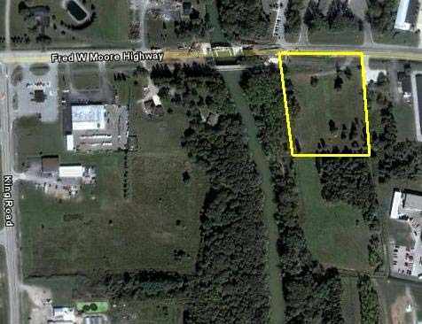
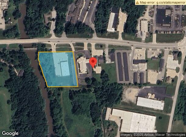
1979 Fred W Moore Hwy, Saint Clair, MI 48079
NEARBY LISTINGS FOR SALE OR LEASE
-
-
View all Saint Clair listings for sale on LoopNet.com
Property Detail
1979 Fred W Moore Hwy
07-055-0035-001
BEG N 87D 10M 30S E 1504.90' FROM INTERSECTION OF S LINE OF SECTION 35 & W LINE OF PC 306, TH N 87D 10M 30S E 28.28', TH N
Storemultistory
St. Clair
AE
Michigan
26147C0434D
3 AC
2024
St Clair & Lapeer Counties
2024
Detroit
642000
Detroit-Warren-Dearborn, MI
9,100 SF
DEMOGRAPHICS near 1979 Fred W Moore Hwy
1 Mile
3 Mile
5 Mile
2024 Total Population
2,718
10,222
15,913
2029 Population
2,701
10,220
15,897
Pop Growth 2024-2029
(0.63%)
(0.02%)
(0.10%)
Average Age
42
45
45
2024 Total Households
1,161
4,340
6,684
HH Growth 2024-2029
(0.78%)
(0.14%)
(0.16%)
Median Household Inc
$75,486
$72,951
$72,380
Avg Household Size
2.30
2.30
2.30
2024 Avg HH Vehicles
2.00
2.00
2.00
Median Home Value
$204,032
$225,127
$240,879
Median Year Built
1970
1971
1976
Nearby Places
- Restaurants
- Banks
- Shops
- Fitness
- Groceries
Nearby Properties
Address
Land Use
TOTAL SIZE
Lot Size
Zoning
Address
Land Use
TOTAL SIZE
Lot Size
Zoning
720,000 SF
Address
Land Use
TOTAL SIZE
Lot Size
Zoning
369,800 SF
Address
Land Use
TOTAL SIZE
Lot Size
Zoning
112,914 SF
9.89 AC
R-3 MLTPLE
Address
Land Use
TOTAL SIZE
Lot Size
Zoning
8.49 AC
RM
Address
Land Use
TOTAL SIZE
Lot Size
Zoning
84,198 SF
8.95 AC
C-2 GENERA
Address
Land Use
TOTAL SIZE
Lot Size
Zoning
133,345 SF
11.69 AC
M-1 LIGHT
Address
Land Use
TOTAL SIZE
Lot Size
Zoning
184,348 SF
17.77 AC
I-1
Address
Land Use
TOTAL SIZE
Lot Size
Zoning
90.62 AC
Address
Land Use
TOTAL SIZE
Lot Size
Zoning
112,486 SF
11.91 AC
M-1 LIGHT
Address
Land Use
TOTAL SIZE
Lot Size
Zoning
137,000 SF
11.14 AC
M-1 LIGHT
Address
Land Use
TOTAL SIZE
Lot Size
Zoning
65,924 SF
6.36 AC
MC
Address
Land Use
TOTAL SIZE
Lot Size
Zoning
579,846 SF
8.21 AC
M-2 HEAVY
Address
Land Use
TOTAL SIZE
Lot Size
Zoning
53,291 SF
Address
Land Use
TOTAL SIZE
Lot Size
Zoning
39,000 SF
8.46 AC
B-2
Address
Land Use
TOTAL SIZE
Lot Size
Zoning
39,423 SF
64.91 AC
I-1
Address
Land Use
TOTAL SIZE
Lot Size
Zoning
46,800 SF
Address
Land Use
TOTAL SIZE
Lot Size
Zoning
66,521 SF
5.78 AC
M-1 LIGHT
Address
Land Use
TOTAL SIZE
Lot Size
Zoning
54,096 SF
6.10 AC
R-1A MED D
Address
Land Use
TOTAL SIZE
Lot Size
Zoning
24,727 SF
0.90 AC
C-1 LOCAL
Address
Land Use
TOTAL SIZE
Lot Size
Zoning
24,261 SF
4.42 AC
C-2 GENERA
Address
Land Use
TOTAL SIZE
Lot Size
Zoning
11,565 SF
4.43 AC
C-2 GENERA
Address
Land Use
TOTAL SIZE
Lot Size
Zoning
12,032 SF
3.31 AC
MC
Address
Land Use
TOTAL SIZE
Lot Size
Zoning
91.42 AC
M-1 LIGHT
Address
Land Use
TOTAL SIZE
Lot Size
Zoning
Address
Land Use
TOTAL SIZE
Lot Size
Zoning
34,726 SF
6.33 AC
R-3 MLTPLE
Address
Land Use
TOTAL SIZE
Lot Size
Zoning
74,400 SF
7.52 AC
M-1 LIGHT
Address
Land Use
TOTAL SIZE
Lot Size
Zoning
19,968 SF
3.50 AC
R-1
Address
Land Use
TOTAL SIZE
Lot Size
Zoning
41,160 SF
M-1 LIGHT
Address
Land Use
TOTAL SIZE
Lot Size
Zoning
7,380 SF
1.82 AC
C-2 GENERA
Address
Land Use
TOTAL SIZE
Lot Size
Zoning
20,196 SF
4.16 AC
C-2 GENERA
The World's #1 Commercial Real Estate Marketplace
Connect with us
© 2025 CoStar Group
The information above has been obtained from sources believed reliable. While we do not doubt its accuracy we have not verified it and make no guarantee, warranty or representation about it. It is your responsibility to independently confirm its accuracy and completeness. Any projections, opinions, assumptions, or estimates used are for example only and do not represent the current or future performance of the property. The value of this transaction to you depends on tax and other factors which should be evaluated by your tax, financial, and legal advisors. You and your advisors should conduct a careful, independent investigation of the property to determine to your satisfaction the suitability of the property for your needs.