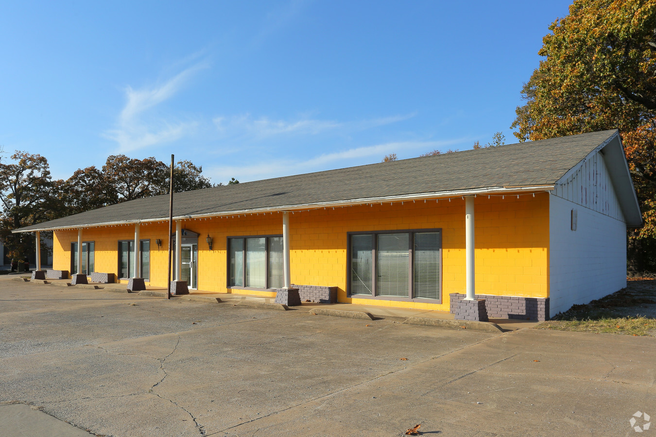
Property Record
1981 W Us 412 Hwy E, Siloam Springs, AR 72761
NEARBY LISTINGS FOR SALE OR LEASE
Property Detail
1981 W Us 412 Hwy E
Fayetteville-Springdale-Rogers, AR-MO
Evans Sub-Siloam Springs
03-02041-000
PART OF LOT 4, EVANS SUBDIVISION, SILOAM SPRINGS, BENTON COUNTY, ARKANSAS, DESCRIBED AS BEGINNING SOUTH 00*1132 WEST 379.05 FEET FROM THE NE CORNER OF SAID LOT 4, THENCE NORTH 89*4815 WEST 170 FEET; THENCE SOUTH 00*1132 WEST 144.77 FEET; THENCE SOUTH
Regionalshoppingcenterormallwithanchorstore
Benton
X
Arkansas
40041C0600E
4
2024
0.56 AC
2024
Outlying Benton County
021101
Fayetteville/Springdale/Rogers
4,500 SF
DEMOGRAPHICS near 1981 W Us 412 Hwy E
1 Mile
3 Mile
5 Mile
2024 Total Population
4,792
20,449
26,174
2029 Population
5,550
23,911
30,478
Pop Growth 2024-2029
+ 15.82%
+ 16.93%
+ 16.44%
Average Age
35
36
37
2024 Total Households
1,544
7,020
9,077
HH Growth 2024-2029
+ 15.87%
+ 16.95%
+ 16.42%
Median Household Inc
$54,326
$59,935
$60,746
Avg Household Size
2.50
2.70
2.70
2024 Avg HH Vehicles
2.00
2.00
2.00
Median Home Value
$165,328
$184,687
$189,719
Median Year Built
1981
1992
1992
Nearby Places
- Restaurants
- Banks
- Shops
- Fitness
- Groceries
PUBLIC TRANSPORTATION
AIRPORT
Northwest Arkansas Ntl
DRIVE
WALK
Distance
Northwest Arkansas Ntl
45 min
24.2 mi
Freight Ports
Tulsa Port of Inola
DRIVE
WALK
Distance
Tulsa Port of Inola
67 min
61.7 mi
SALE & LEASE HISTORY
LISTING DATE
SALE/LEASE

Sep 01, 2017
For Sale
Nov 18, 2021
For Lease
Nov 15, 2016
For Sale
Nearby Properties
Address
Land Use
TOTAL SIZE
Lot Size
Zoning
Address
Land Use
TOTAL SIZE
Lot Size
Zoning
85,903 SF
10 AC
Address
Land Use
TOTAL SIZE
Lot Size
Zoning
140,452 SF
9.28 AC
Address
Land Use
TOTAL SIZE
Lot Size
Zoning
183,822 SF
23.62 AC
Address
Land Use
TOTAL SIZE
Lot Size
Zoning
190,712 SF
15.73 AC
Address
Land Use
TOTAL SIZE
Lot Size
Zoning
119,258 SF
16.25 AC
Address
Land Use
TOTAL SIZE
Lot Size
Zoning
30,542 SF
66.48 AC
Address
Land Use
TOTAL SIZE
Lot Size
Zoning
190,790 SF
25.17 AC
Address
Land Use
TOTAL SIZE
Lot Size
Zoning
422,489 SF
57.90 AC
Address
Land Use
TOTAL SIZE
Lot Size
Zoning
53,071 SF
2.07 AC
Address
Land Use
TOTAL SIZE
Lot Size
Zoning
110,904 SF
15.22 AC
Address
Land Use
TOTAL SIZE
Lot Size
Zoning
264,685 SF
14.13 AC
Address
Land Use
TOTAL SIZE
Lot Size
Zoning
23,133 SF
3 AC
Address
Land Use
TOTAL SIZE
Lot Size
Zoning
31,887 SF
1.61 AC
Address
Land Use
TOTAL SIZE
Lot Size
Zoning
98,492 SF
6.33 AC
Address
Land Use
TOTAL SIZE
Lot Size
Zoning
20,475 SF
19.62 AC
Address
Land Use
TOTAL SIZE
Lot Size
Zoning
21,974 SF
3.87 AC
Address
Land Use
TOTAL SIZE
Lot Size
Zoning
92,300 SF
6.35 AC
Address
Land Use
TOTAL SIZE
Lot Size
Zoning
144,166 SF
12.49 AC
Address
Land Use
TOTAL SIZE
Lot Size
Zoning
87,684 SF
5.43 AC
Address
Land Use
TOTAL SIZE
Lot Size
Zoning
36,185 SF
0.78 AC
Address
Land Use
TOTAL SIZE
Lot Size
Zoning
64,710 SF
2.32 AC
Address
Land Use
TOTAL SIZE
Lot Size
Zoning
57,503 SF
7.08 AC
Address
Land Use
TOTAL SIZE
Lot Size
Zoning
41,748 SF
5.44 AC
Address
Land Use
TOTAL SIZE
Lot Size
Zoning
20,714 SF
0.57 AC
Address
Land Use
TOTAL SIZE
Lot Size
Zoning
40,709 SF
4.24 AC
Address
Land Use
TOTAL SIZE
Lot Size
Zoning
4,888 SF
5.30 AC
Address
Land Use
TOTAL SIZE
Lot Size
Zoning
63,439 SF
5.17 AC
Address
Land Use
TOTAL SIZE
Lot Size
Zoning
43,438 SF
6.44 AC
Address
Land Use
TOTAL SIZE
Lot Size
Zoning
244,723 SF
18.51 AC
Address
Land Use
TOTAL SIZE
Lot Size
Zoning
19,820 SF
2.48 AC
The World's #1 Commercial Real Estate Marketplace
Connect with us
© 2025 CoStar Group
The information above has been obtained from sources believed reliable. While we do not doubt its accuracy we have not verified it and make no guarantee, warranty or representation about it. It is your responsibility to independently confirm its accuracy and completeness. Any projections, opinions, assumptions, or estimates used are for example only and do not represent the current or future performance of the property. The value of this transaction to you depends on tax and other factors which should be evaluated by your tax, financial, and legal advisors. You and your advisors should conduct a careful, independent investigation of the property to determine to your satisfaction the suitability of the property for your needs.