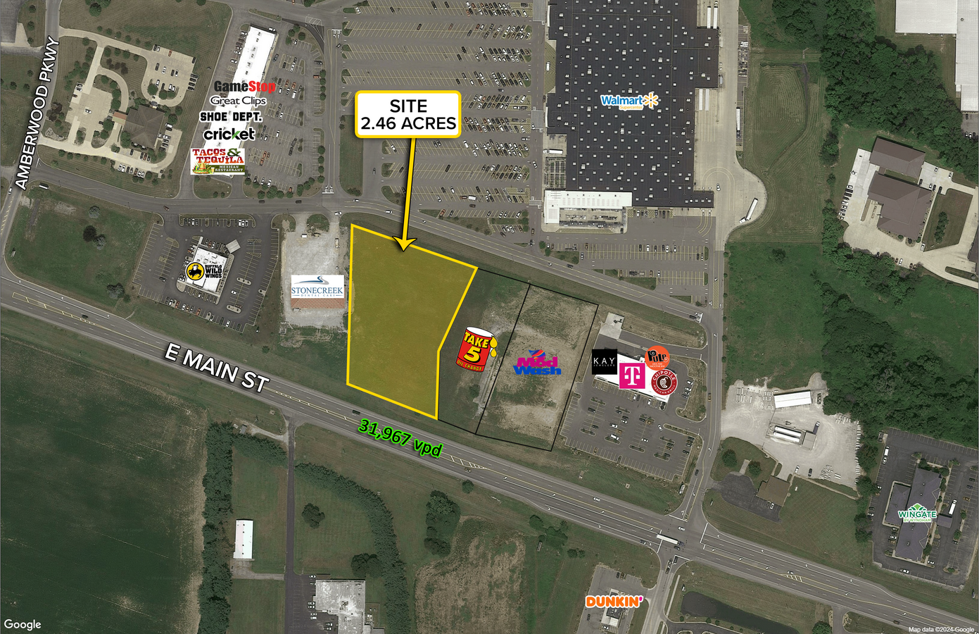
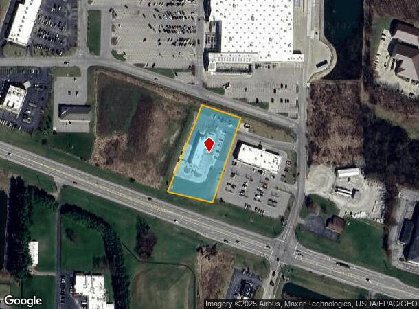
Property Record
1992 E Main St, Ashland, OH 44805
NEARBY LISTINGS FOR SALE OR LEASE
-
-
View all Ashland listings for lease on LoopNet.com
Property Detail
1992 E Main St
P43-196-0-0002-00
1992 E MAIN ST R=196-198 PARCEL
Carwash
Ashland
X
Ohio
39005C0235E
5.30 AC
2024
Ohio North Area
2024
Other Market Areas
970800
Ashland, OH
4,500 SF
DEMOGRAPHICS near 1992 E Main St
1 Mile
3 Mile
5 Mile
2024 Total Population
1,143
17,391
26,464
2029 Population
1,185
17,555
26,609
Pop Growth 2024-2029
+ 3.67%
+ 0.94%
+ 0.55%
Average Age
48
41
42
2024 Total Households
454
7,173
10,894
HH Growth 2024-2029
+ 4.19%
+ 0.96%
+ 0.55%
Median Household Inc
$49,518
$52,896
$56,326
Avg Household Size
2.20
2.20
2.30
2024 Avg HH Vehicles
2.00
2.00
2.00
Median Home Value
$192,916
$128,804
$144,596
Median Year Built
2002
1956
1962
Nearby Places
- Restaurants
- Banks
- Shops
- Fitness
- Groceries
SALE & LEASE HISTORY
LISTING DATE
SALE/LEASE

May 15, 2018
For Lease
Jan 16, 2024
For Lease
Jan 16, 2024
For Sale
Feb 01, 2018
For Sale
Aug 14, 2020
For Lease
Nearby Properties
Address
Land Use
TOTAL SIZE
Lot Size
Zoning
Address
Land Use
TOTAL SIZE
Lot Size
Zoning
7,737 SF
16.67 AC
Address
Land Use
TOTAL SIZE
Lot Size
Zoning
125,000 SF
2.57 AC
Address
Land Use
TOTAL SIZE
Lot Size
Zoning
3,786 SF
11.90 AC
Address
Land Use
TOTAL SIZE
Lot Size
Zoning
3,988 SF
15.28 AC
Address
Land Use
TOTAL SIZE
Lot Size
Zoning
602,490 SF
30.07 AC
Address
Land Use
TOTAL SIZE
Lot Size
Zoning
792 SF
47.90 AC
Address
Land Use
TOTAL SIZE
Lot Size
Zoning
15,279 SF
69.95 AC
Address
Land Use
TOTAL SIZE
Lot Size
Zoning
104,076 SF
5 AC
Address
Land Use
TOTAL SIZE
Lot Size
Zoning
37,974 SF
7.34 AC
Address
Land Use
TOTAL SIZE
Lot Size
Zoning
39,229 SF
13.46 AC
Address
Land Use
TOTAL SIZE
Lot Size
Zoning
62,667 SF
2.80 AC
Address
Land Use
TOTAL SIZE
Lot Size
Zoning
215,905 SF
38.12 AC
Address
Land Use
TOTAL SIZE
Lot Size
Zoning
0.22 AC
Address
Land Use
TOTAL SIZE
Lot Size
Zoning
74,191 SF
6.81 AC
Address
Land Use
TOTAL SIZE
Lot Size
Zoning
95,413 SF
0.20 AC
Address
Land Use
TOTAL SIZE
Lot Size
Zoning
71,621 SF
6.18 AC
Address
Land Use
TOTAL SIZE
Lot Size
Zoning
57,097 SF
25.50 AC
Address
Land Use
TOTAL SIZE
Lot Size
Zoning
93,760 SF
132.08 AC
Address
Land Use
TOTAL SIZE
Lot Size
Zoning
1,411 SF
10.44 AC
Address
Land Use
TOTAL SIZE
Lot Size
Zoning
50,000 SF
14.43 AC
Address
Land Use
TOTAL SIZE
Lot Size
Zoning
46,137 SF
0.20 AC
Address
Land Use
TOTAL SIZE
Lot Size
Zoning
576 SF
19.97 AC
Address
Land Use
TOTAL SIZE
Lot Size
Zoning
40,091 SF
0.17 AC
Address
Land Use
TOTAL SIZE
Lot Size
Zoning
8,283 SF
9 AC
Address
Land Use
TOTAL SIZE
Lot Size
Zoning
30,971 SF
5.86 AC
Address
Land Use
TOTAL SIZE
Lot Size
Zoning
19,069 SF
8.09 AC
Address
Land Use
TOTAL SIZE
Lot Size
Zoning
10,224 SF
2.80 AC
Address
Land Use
TOTAL SIZE
Lot Size
Zoning
82,259 SF
12.37 AC
Address
Land Use
TOTAL SIZE
Lot Size
Zoning
59,348 SF
1.24 AC
Address
Land Use
TOTAL SIZE
Lot Size
Zoning
58,435 SF
3 AC
The World's #1 Commercial Real Estate Marketplace
Connect with us
© 2025 CoStar Group
The information above has been obtained from sources believed reliable. While we do not doubt its accuracy we have not verified it and make no guarantee, warranty or representation about it. It is your responsibility to independently confirm its accuracy and completeness. Any projections, opinions, assumptions, or estimates used are for example only and do not represent the current or future performance of the property. The value of this transaction to you depends on tax and other factors which should be evaluated by your tax, financial, and legal advisors. You and your advisors should conduct a careful, independent investigation of the property to determine to your satisfaction the suitability of the property for your needs.