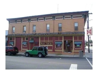
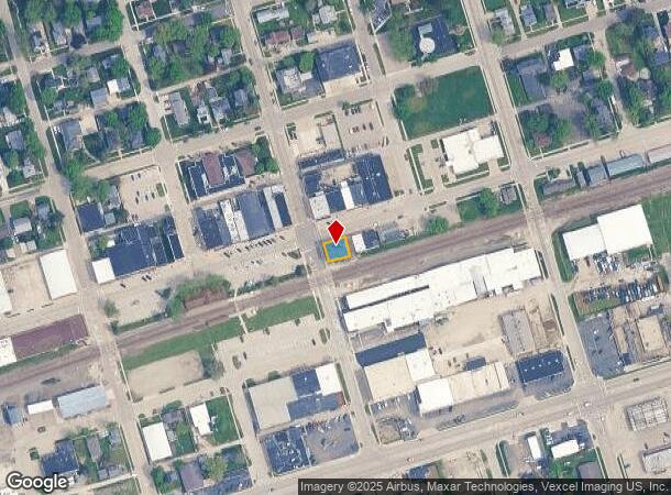
Property Record
2 E Main St, Plano, IL 60545
NEARBY LISTINGS FOR SALE OR LEASE
-
-
-
No Photo
-
View all Plano listings for sale on LoopNet.com
Property Detail
2 E Main St
Chicago-Naperville-Elgin, IL-IN-WI
City Of Plano
01-22-386-001
W 60 LOT 1 BLK 1 CITY OF PLANO
Commercialnec
Kendall
X
Illinois
17099C0150F
1
2024
0.07 AC
2024
Western East/West Corr
890502
Chicago
5,280 SF
DEMOGRAPHICS near 2 E Main St
1 Mile
3 Mile
5 Mile
2024 Total Population
6,199
15,502
31,993
2029 Population
6,889
17,113
34,654
Pop Growth 2024-2029
+ 11.13%
+ 10.39%
+ 8.32%
Average Age
37
36
38
2024 Total Households
2,146
5,161
11,179
HH Growth 2024-2029
+ 11.09%
+ 10.48%
+ 8.12%
Median Household Inc
$62,683
$72,077
$80,252
Avg Household Size
2.80
2.90
2.80
2024 Avg HH Vehicles
2.00
2.00
2.00
Median Home Value
$178,749
$201,007
$226,784
Median Year Built
1964
1997
1992
Nearby Places
Map Layers
Map Styles
 Street
 Aerial
- Restaurants
- Banks
- Shops
- Fitness
- Groceries
PUBLIC TRANSPORTATION
COMMUTER RAIL
Plano Amtrak Station (Carl Sandburg - Amtrak, Illinois Zephyr - Amtrak)
DRIVE
WALK
Distance
Plano Amtrak Station (Carl Sandburg - Amtrak, Illinois Zephyr - Amtrak)
0 min
1 min
0.1 mi
Freight Ports
Port Milwaukee
DRIVE
WALK
Distance
Port Milwaukee
158 min
126.1 mi
SALE & LEASE HISTORY
LISTING DATE
SALE/LEASE

Sep 25, 2016
For Lease
Aug 22, 2023
For Sale
Nearby Properties
Address
Land Use
TOTAL SIZE
Lot Size
Zoning
Address
Land Use
TOTAL SIZE
Lot Size
Zoning
1,703,170 SF
266.50 AC
Address
Land Use
TOTAL SIZE
Lot Size
Zoning
178,669 SF
21.48 AC
Address
Land Use
TOTAL SIZE
Lot Size
Zoning
34,047 SF
7.36 AC
Address
Land Use
TOTAL SIZE
Lot Size
Zoning
63,947 SF
3.04 AC
Address
Land Use
TOTAL SIZE
Lot Size
Zoning
62,648 SF
3.06 AC
Address
Land Use
TOTAL SIZE
Lot Size
Zoning
20,654 SF
2.38 AC
Address
Land Use
TOTAL SIZE
Lot Size
Zoning
15,632 SF
2.83 AC
Address
Land Use
TOTAL SIZE
Lot Size
Zoning
9.03 AC
Address
Land Use
TOTAL SIZE
Lot Size
Zoning
16,296 SF
1.17 AC
Address
Land Use
TOTAL SIZE
Lot Size
Zoning
15.41 AC
Address
Land Use
TOTAL SIZE
Lot Size
Zoning
52,672 SF
6.43 AC
Address
Land Use
TOTAL SIZE
Lot Size
Zoning
18,712 SF
1.38 AC
Address
Land Use
TOTAL SIZE
Lot Size
Zoning
1.46 AC
Address
Land Use
TOTAL SIZE
Lot Size
Zoning
12,570 SF
1.28 AC
Address
Land Use
TOTAL SIZE
Lot Size
Zoning
70,912 SF
7.15 AC
Address
Land Use
TOTAL SIZE
Lot Size
Zoning
17,608 SF
1.94 AC
Address
Land Use
TOTAL SIZE
Lot Size
Zoning
33,543 SF
2.37 AC
Address
Land Use
TOTAL SIZE
Lot Size
Zoning
10,048 SF
1.31 AC
Address
Land Use
TOTAL SIZE
Lot Size
Zoning
5,027 SF
1.37 AC
Address
Land Use
TOTAL SIZE
Lot Size
Zoning
5.37 AC
Address
Land Use
TOTAL SIZE
Lot Size
Zoning
3,956 SF
1 AC
Address
Land Use
TOTAL SIZE
Lot Size
Zoning
17,990 SF
4.54 AC
Address
Land Use
TOTAL SIZE
Lot Size
Zoning
0.67 AC
Address
Land Use
TOTAL SIZE
Lot Size
Zoning
6,600 SF
1.15 AC
Address
Land Use
TOTAL SIZE
Lot Size
Zoning
5,172 SF
56.79 AC
Address
Land Use
TOTAL SIZE
Lot Size
Zoning
26,400 SF
3.14 AC
Address
Land Use
TOTAL SIZE
Lot Size
Zoning
37,100 SF
1.89 AC
Address
Land Use
TOTAL SIZE
Lot Size
Zoning
3,155 SF
1.22 AC
Address
Land Use
TOTAL SIZE
Lot Size
Zoning
12,311 SF
2.18 AC
The World's #1 Commercial Real Estate Marketplace
Connect with us
© 2025 CoStar Group
The information above has been obtained from sources believed reliable. While we do not doubt its accuracy we have not verified it and make no guarantee, warranty or representation about it. It is your responsibility to independently confirm its accuracy and completeness. Any projections, opinions, assumptions, or estimates used are for example only and do not represent the current or future performance of the property. The value of this transaction to you depends on tax and other factors which should be evaluated by your tax, financial, and legal advisors. You and your advisors should conduct a careful, independent investigation of the property to determine to your satisfaction the suitability of the property for your needs.