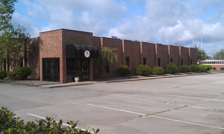
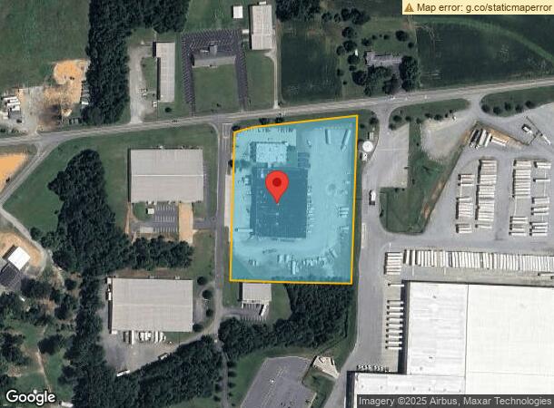
Property Record
2 Regency Industrial Blvd, Thomasville, NC 27360
NEARBY LISTINGS FOR SALE OR LEASE
Property Detail
2 Regency Industrial Blvd
16-336-0-000-0036-B-0-0
L36B BK2224-747 749 NC 62
Publicstorage
Davidson
X
North Carolina
3710678700J
5.44 AC
2024
North Davidson County
2024
Greensboro/Winston-Salem
061102
Winston-Salem, NC
52,859 SF
DEMOGRAPHICS near 2 Regency Industrial Blvd
1 Mile
3 Mile
5 Mile
2024 Total Population
3,511
30,078
53,641
2029 Population
3,677
31,739
56,310
Pop Growth 2024-2029
+ 4.73%
+ 5.52%
+ 4.98%
Average Age
42
40
41
2024 Total Households
1,406
12,029
21,448
HH Growth 2024-2029
+ 4.69%
+ 5.42%
+ 4.89%
Median Household Inc
$61,507
$50,825
$52,195
Avg Household Size
2.40
2.40
2.40
2024 Avg HH Vehicles
2.00
2.00
2.00
Median Home Value
$172,232
$155,861
$156,606
Median Year Built
1985
1977
1980
Nearby Places
- Restaurants
- Banks
- Shops
- Fitness
- Groceries
PUBLIC TRANSPORTATION
COMMUTER RAIL
High Point Station (Piedmont - North Carolina by Train (NC Train))
DRIVE
WALK
Distance
High Point Station (Piedmont - North Carolina by Train (NC Train))
18 min
9.6 mi
AIRPORT
Piedmont Triad International
DRIVE
WALK
Distance
Piedmont Triad International
38 min
27.0 mi
Freight Ports
Port of Wilmington
DRIVE
WALK
Distance
Port of Wilmington
252 min
208.5 mi
Nearby Properties
Address
Land Use
TOTAL SIZE
Lot Size
Zoning
Address
Land Use
TOTAL SIZE
Lot Size
Zoning
154,870 SF
62.93 AC
M1
Address
Land Use
TOTAL SIZE
Lot Size
Zoning
51,988 SF
82.73 AC
OI
Address
Land Use
TOTAL SIZE
Lot Size
Zoning
194,644 SF
20 AC
R10
Address
Land Use
TOTAL SIZE
Lot Size
Zoning
35.69 AC
OI
Address
Land Use
TOTAL SIZE
Lot Size
Zoning
223,384 SF
25.63 AC
C3
Address
Land Use
TOTAL SIZE
Lot Size
Zoning
4,480 SF
20.67 AC
R10
Address
Land Use
TOTAL SIZE
Lot Size
Zoning
13,770 SF
34.64 AC
R10
Address
Land Use
TOTAL SIZE
Lot Size
Zoning
20,016 SF
135.18 AC
M1CZ
Address
Land Use
TOTAL SIZE
Lot Size
Zoning
41,284 SF
19.05 AC
R10
Address
Land Use
TOTAL SIZE
Lot Size
Zoning
900 SF
7.52 AC
C2
Address
Land Use
TOTAL SIZE
Lot Size
Zoning
56,305 SF
5.39 AC
OI
Address
Land Use
TOTAL SIZE
Lot Size
Zoning
127,280 SF
29.10 AC
M2CZ
Address
Land Use
TOTAL SIZE
Lot Size
Zoning
82,160 SF
23.62 AC
C2
Address
Land Use
TOTAL SIZE
Lot Size
Zoning
12,536 SF
300.20 AC
M1CZ
Address
Land Use
TOTAL SIZE
Lot Size
Zoning
1,104 SF
50.07 AC
M2
Address
Land Use
TOTAL SIZE
Lot Size
Zoning
72,642 SF
10.53 AC
R10
Address
Land Use
TOTAL SIZE
Lot Size
Zoning
124,326 SF
13.45 AC
C3
Address
Land Use
TOTAL SIZE
Lot Size
Zoning
43,000 SF
8.63 AC
C2
Address
Land Use
TOTAL SIZE
Lot Size
Zoning
149,129 SF
15.65 AC
R10
Address
Land Use
TOTAL SIZE
Lot Size
Zoning
44,432 SF
22.13 AC
R10
Address
Land Use
TOTAL SIZE
Lot Size
Zoning
63,643 SF
8.46 AC
M1
Address
Land Use
TOTAL SIZE
Lot Size
Zoning
162,000 SF
10.67 AC
M1
Address
Land Use
TOTAL SIZE
Lot Size
Zoning
52,466 SF
3.57 AC
C2
Address
Land Use
TOTAL SIZE
Lot Size
Zoning
39,842 SF
12.49 AC
M2
Address
Land Use
TOTAL SIZE
Lot Size
Zoning
1,152 SF
0.03 AC
RA3
Address
Land Use
TOTAL SIZE
Lot Size
Zoning
63,730 SF
19.47 AC
R10
Address
Land Use
TOTAL SIZE
Lot Size
Zoning
2,460 SF
26.64 AC
R8
Address
Land Use
TOTAL SIZE
Lot Size
Zoning
44,862 SF
4.38 AC
C3
Address
Land Use
TOTAL SIZE
Lot Size
Zoning
42,262 SF
6.73 AC
M1
Address
Land Use
TOTAL SIZE
Lot Size
Zoning
114,220 SF
69.22 AC
M1
The World's #1 Commercial Real Estate Marketplace
Connect with us
© 2025 CoStar Group
The information above has been obtained from sources believed reliable. While we do not doubt its accuracy we have not verified it and make no guarantee, warranty or representation about it. It is your responsibility to independently confirm its accuracy and completeness. Any projections, opinions, assumptions, or estimates used are for example only and do not represent the current or future performance of the property. The value of this transaction to you depends on tax and other factors which should be evaluated by your tax, financial, and legal advisors. You and your advisors should conduct a careful, independent investigation of the property to determine to your satisfaction the suitability of the property for your needs.