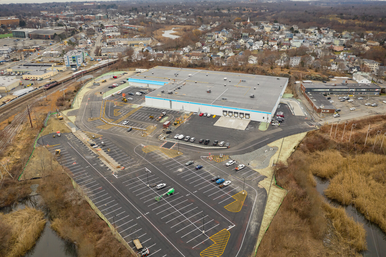
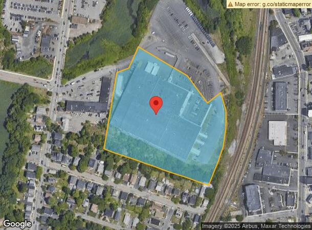
Property Record
20 Colonial Rd, Salem, MA 01970
NEARBY LISTINGS FOR SALE OR LEASE
Property Detail
20 Colonial Rd
SALE-000024-000000-000121
Essex
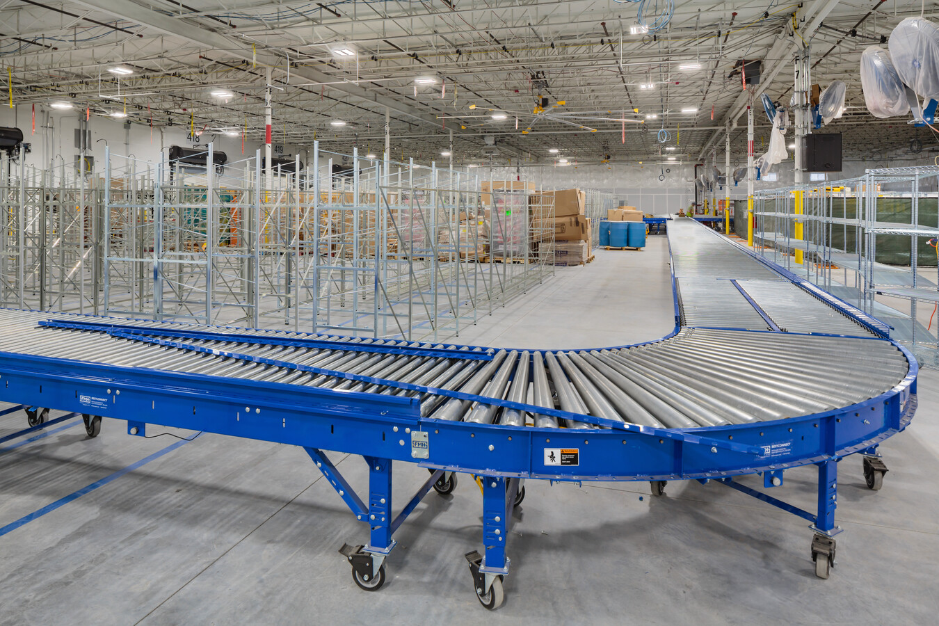
Warehouse
Massachusetts
AE
121
25009C0419G
6.10 AC
2025
Peabody/Salem
2025
Boston
204200
Boston-Cambridge-Newton, MA-NH
145,500 SF
DEMOGRAPHICS near 20 Colonial Rd
1 Mile
3 Mile
5 Mile
2024 Total Population
22,782
125,874
260,170
2029 Population
22,462
124,777
257,705
Pop Growth 2024-2029
(1.40%)
(0.87%)
(0.95%)
Average Age
39
41
41
2024 Total Households
9,539
52,065
102,734
HH Growth 2024-2029
(1.62%)
(1.03%)
(0.99%)
Median Household Inc
$68,092
$85,429
$78,971
Avg Household Size
2.20
2.30
2.40
2024 Avg HH Vehicles
1.00
2.00
2.00
Median Home Value
$464,681
$552,832
$498,712
Median Year Built
1948
1949
1952
Nearby Places
- Restaurants
- Banks
- Shops
- Fitness
- Groceries
PUBLIC TRANSPORTATION
COMMUTER RAIL
Salem (Newburyport/Rockport Line - Massachusetts Bay Transportation Authority Commuter Rail (Purple Line))
DRIVE
WALK
Distance
Salem (Newburyport/Rockport Line - Massachusetts Bay Transportation Authority Commuter Rail (Purple Line))
4 min
1.5 mi
Beverly Depot (Newburyport/Rockport Line - Massachusetts Bay Transportation Authority Commuter Rail (Purple Line))
DRIVE
WALK
Distance
Beverly Depot (Newburyport/Rockport Line - Massachusetts Bay Transportation Authority Commuter Rail (Purple Line))
8 min
3.2 mi
AIRPORT
General Edward Lawrence Logan International
DRIVE
WALK
Distance
General Edward Lawrence Logan International
26 min
14.5 mi
Freight Ports
Port of Boston
DRIVE
WALK
Distance
Port of Boston
32 min
17.2 mi
SALE & LEASE HISTORY
LISTING DATE
SALE/LEASE

Jul 01, 2019
For Lease
Nearby Properties
Address
Land Use
TOTAL SIZE
Lot Size
Zoning
Address
Land Use
TOTAL SIZE
Lot Size
Zoning
10,368 SF
33.83 AC
R3
Address
Land Use
TOTAL SIZE
Lot Size
Zoning
14.69 AC
I
Address
Land Use
TOTAL SIZE
Lot Size
Zoning
9,860 SF
17.80 AC
R1
Address
Land Use
TOTAL SIZE
Lot Size
Zoning
192,341 SF
2.10 AC
B5
Address
Land Use
TOTAL SIZE
Lot Size
Zoning
154,524 SF
11.80 AC
B3
Address
Land Use
TOTAL SIZE
Lot Size
Zoning
29.12 AC
I
Address
Land Use
TOTAL SIZE
Lot Size
Zoning
38,440 SF
8.95 AC
I
Address
Land Use
TOTAL SIZE
Lot Size
Zoning
223,689 SF
11.60 AC
R1
Address
Land Use
TOTAL SIZE
Lot Size
Zoning
205,353 SF
18.74 AC
Address
Land Use
TOTAL SIZE
Lot Size
Zoning
190,000 SF
24.42 AC
N/A
Address
Land Use
TOTAL SIZE
Lot Size
Zoning
25.72 AC
IP
Address
Land Use
TOTAL SIZE
Lot Size
Zoning
4.14 AC
NRCC
Address
Land Use
TOTAL SIZE
Lot Size
Zoning
28.30 AC
IP
Address
Land Use
TOTAL SIZE
Lot Size
Zoning
118,110 SF
0.66 AC
CC
Address
Land Use
TOTAL SIZE
Lot Size
Zoning
9.58 AC
R3
Address
Land Use
TOTAL SIZE
Lot Size
Zoning
14.50 AC
R1
Address
Land Use
TOTAL SIZE
Lot Size
Zoning
123,588 SF
1.50 AC
B5
Address
Land Use
TOTAL SIZE
Lot Size
Zoning
125,862 SF
5.30 AC
R1
Address
Land Use
TOTAL SIZE
Lot Size
Zoning
5 AC
B2
Address
Land Use
TOTAL SIZE
Lot Size
Zoning
112,023 SF
0.74 AC
CC
Address
Land Use
TOTAL SIZE
Lot Size
Zoning
77,392 SF
13.64 AC
B3
Address
Land Use
TOTAL SIZE
Lot Size
Zoning
80,069 SF
3.13 AC
A-2
Address
Land Use
TOTAL SIZE
Lot Size
Zoning
7.28 AC
R3
Address
Land Use
TOTAL SIZE
Lot Size
Zoning
229,416 SF
29.62 AC
N/A
Address
Land Use
TOTAL SIZE
Lot Size
Zoning
40,939 SF
12.48 AC
Address
Land Use
TOTAL SIZE
Lot Size
Zoning
19.52 AC
R3
Address
Land Use
TOTAL SIZE
Lot Size
Zoning
22.35 AC
R1
Address
Land Use
TOTAL SIZE
Lot Size
Zoning
42.30 AC
I
Address
Land Use
TOTAL SIZE
Lot Size
Zoning
13.26 AC
B2
Address
Land Use
TOTAL SIZE
Lot Size
Zoning
5,236 SF
32.40 AC
IL
The World's #1 Commercial Real Estate Marketplace
Connect with us
© 2025 CoStar Group
The information above has been obtained from sources believed reliable. While we do not doubt its accuracy we have not verified it and make no guarantee, warranty or representation about it. It is your responsibility to independently confirm its accuracy and completeness. Any projections, opinions, assumptions, or estimates used are for example only and do not represent the current or future performance of the property. The value of this transaction to you depends on tax and other factors which should be evaluated by your tax, financial, and legal advisors. You and your advisors should conduct a careful, independent investigation of the property to determine to your satisfaction the suitability of the property for your needs.