Property Record
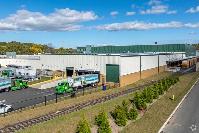
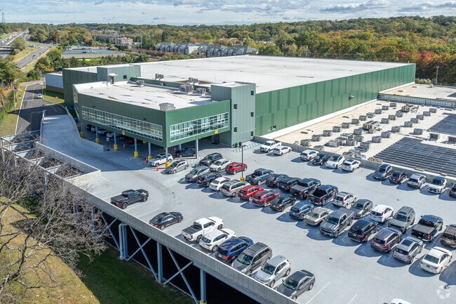
20 Dunnigan Dr, Suffern, NY 10901

NEARBY LISTINGS FOR SALE OR LEASE
Property Detail
20 Dunnigan Dr
392617-055-007-0001-012-000-0000
Rockland
Warehouse
New York
X
12.0
34003C0076H
21.12 AC
2023
Rockland County
2024
Northern New Jersey
010504
New York-Jersey City-White Plains, NY-NJ
338,337 SF
DEMOGRAPHICS near 20 Dunnigan Dr
1 Mile
3 Mile
5 Mile
2024 Total Population
8,739
71,448
190,958
2029 Population
8,748
71,096
190,355
Pop Growth 2024-2029
+ 0.10%
(0.49%)
(0.32%)
Average Age
44
35
35
2024 Total Households
3,413
21,305
54,715
HH Growth 2024-2029
+ 0.09%
(0.43%)
(0.24%)
Median Household Inc
$102,766
$92,919
$93,319
Avg Household Size
2.50
3.20
3.30
2024 Avg HH Vehicles
2.00
2.00
2.00
Median Home Value
$396,883
$602,557
$620,082
Median Year Built
1975
1975
1975
Nearby Places
Map Layers
Map Styles
 Street
 Aerial
- Restaurants
- Banks
- Shops
- Fitness
- Groceries
PUBLIC TRANSPORTATION
COMMUTER RAIL
Suffern (Bergen County/Port Jervis Line - NJ Transit Commuter Rail (NJ Transit), Main/Port Jervis Line - NJ Transit Commuter Rail (NJ Transit))
DRIVE
WALK
Distance
Suffern (Bergen County/Port Jervis Line - NJ Transit Commuter Rail (NJ Transit), Main/Port Jervis Line - NJ Transit Commuter Rail (NJ Transit))
6 min
2.9 mi
Mahwah (Bergen County/Port Jervis Line - NJ Transit Commuter Rail (NJ Transit), Main/Port Jervis Line - NJ Transit Commuter Rail (NJ Transit))
DRIVE
WALK
Distance
Mahwah (Bergen County/Port Jervis Line - NJ Transit Commuter Rail (NJ Transit), Main/Port Jervis Line - NJ Transit Commuter Rail (NJ Transit))
8 min
4.0 mi
AIRPORT
Westchester County
DRIVE
WALK
Distance
Westchester County
40 min
28.7 mi
LaGuardia
DRIVE
WALK
Distance
LaGuardia
53 min
36.4 mi
New York Stewart International
DRIVE
WALK
Distance
New York Stewart International
50 min
37.7 mi
Freight Ports
Port Newark Container Terminal
DRIVE
WALK
Distance
Port Newark Container Terminal
52 min
38.7 mi
Nearby Properties
Address
Land Use
TOTAL SIZE
Lot Size
Zoning
Address
Land Use
TOTAL SIZE
Lot Size
Zoning
46.89 AC
IP120
Address
Land Use
TOTAL SIZE
Lot Size
Zoning
1,056 SF
99.35 AC
OP200
Address
Land Use
TOTAL SIZE
Lot Size
Zoning
61.37 AC
PED
Address
Land Use
TOTAL SIZE
Lot Size
Zoning
23.32 AC
Address
Land Use
TOTAL SIZE
Lot Size
Zoning
14.09 AC
B200
Address
Land Use
TOTAL SIZE
Lot Size
Zoning
Address
Land Use
TOTAL SIZE
Lot Size
Zoning
68.78 AC
OP20
Address
Land Use
TOTAL SIZE
Lot Size
Zoning
609,540 SF
174.09 AC
R-50
Address
Land Use
TOTAL SIZE
Lot Size
Zoning
19.60 AC
OP200
Address
Land Use
TOTAL SIZE
Lot Size
Zoning
5.67 AC
Address
Land Use
TOTAL SIZE
Lot Size
Zoning
539,911 SF
38.80 AC
05
Address
Land Use
TOTAL SIZE
Lot Size
Zoning
33.50 AC
GI80
Address
Land Use
TOTAL SIZE
Lot Size
Zoning
91,596 SF
15.10 AC
B40
Address
Land Use
TOTAL SIZE
Lot Size
Zoning
68,905 SF
7.28 AC
LO
Address
Land Use
TOTAL SIZE
Lot Size
Zoning
219,765 SF
29.88 AC
07
Address
Land Use
TOTAL SIZE
Lot Size
Zoning
60,222 SF
17.39 AC
LO
Address
Land Use
TOTAL SIZE
Lot Size
Zoning
5.30 AC
GA200
Address
Land Use
TOTAL SIZE
Lot Size
Zoning
0.44 AC
OP20
Address
Land Use
TOTAL SIZE
Lot Size
Zoning
9 AC
B40
Address
Land Use
TOTAL SIZE
Lot Size
Zoning
43,828 SF
3 AC
LO
Address
Land Use
TOTAL SIZE
Lot Size
Zoning
7.26 AC
GA200
Address
Land Use
TOTAL SIZE
Lot Size
Zoning
5.31 AC
GA200
Address
Land Use
TOTAL SIZE
Lot Size
Zoning
11.09 AC
IP120
Address
Land Use
TOTAL SIZE
Lot Size
Zoning
3.65 AC
Address
Land Use
TOTAL SIZE
Lot Size
Zoning
12.06 AC
GI80
Address
Land Use
TOTAL SIZE
Lot Size
Zoning
2.96 AC
I200
Address
Land Use
TOTAL SIZE
Lot Size
Zoning
2.43 AC
B40
Address
Land Use
TOTAL SIZE
Lot Size
Zoning
5.46 AC
1200
Address
Land Use
TOTAL SIZE
Lot Size
Zoning
12.53 AC
IP120
Address
Land Use
TOTAL SIZE
Lot Size
Zoning
4.71 AC
GA200
The World's #1 Commercial Real Estate Marketplace
Connect with us
© 2026 CoStar Group
The information above has been obtained from sources believed reliable. While we do not doubt its accuracy we have not verified it and make no guarantee, warranty or representation about it. It is your responsibility to independently confirm its accuracy and completeness. Any projections, opinions, assumptions, or estimates used are for example only and do not represent the current or future performance of the property. The value of this transaction to you depends on tax and other factors which should be evaluated by your tax, financial, and legal advisors. You and your advisors should conduct a careful, independent investigation of the property to determine to your satisfaction the suitability of the property for your needs.