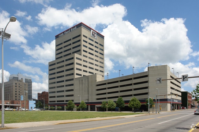
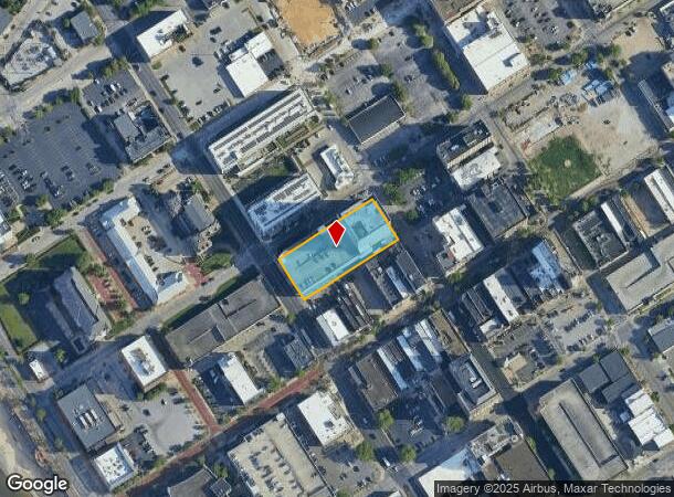
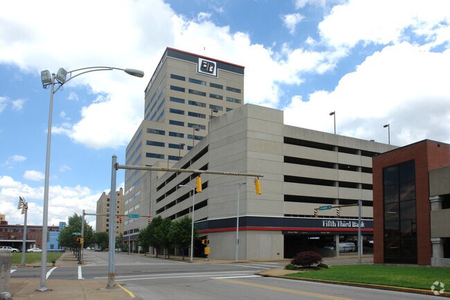
Property Record
20 Nw 3Rd St, Evansville, IN 47708
Current Lease Availabilities
NEARBY LISTINGS FOR SALE OR LEASE
Property Detail
20 Nw 3Rd St
Evansville, IN-KY
Original Plan The City Evansvi
82-06-30-020-015.001-029
ORIGINAL PLAN LOTS 129, 130, 111, 112 & PT VAC ADJ ALLEY
Officebuilding
Vanderburgh
X
Indiana
21101C0080F
129-130
2024
0.96 AC
2024
Downtown Evansville
001800
Evansville
331,588 SF
DEMOGRAPHICS near 20 Nw 3Rd St
1 Mile
3 Mile
5 Mile
2024 Total Population
8,080
66,501
121,635
2029 Population
8,428
67,584
122,376
Pop Growth 2024-2029
+ 4.31%
+ 1.63%
+ 0.61%
Average Age
41
39
40
2024 Total Households
3,896
28,761
53,364
HH Growth 2024-2029
+ 4.77%
+ 1.68%
+ 0.60%
Median Household Inc
$35,074
$43,469
$47,688
Avg Household Size
1.90
2.20
2.20
2024 Avg HH Vehicles
1.00
2.00
2.00
Median Home Value
$110,924
$82,894
$113,900
Median Year Built
1951
1949
1959
Nearby Places
Map Layers
Map Styles
 Street
 Aerial
- Restaurants
- Banks
- Shops
- Fitness
- Groceries
PUBLIC TRANSPORTATION
AIRPORT
Evansville Regional
DRIVE
WALK
Distance
Evansville Regional
13 min
6.4 mi
Freight Ports
Port of Toledo
DRIVE
WALK
Distance
Port of Toledo
461 min
395.7 mi
Nearby Properties
Address
Land Use
TOTAL SIZE
Lot Size
Zoning
Address
Land Use
TOTAL SIZE
Lot Size
Zoning
84,660 SF
12.95 AC
Address
Land Use
TOTAL SIZE
Lot Size
Zoning
20,964 SF
1.35 AC
Address
Land Use
TOTAL SIZE
Lot Size
Zoning
15,233 SF
3.31 AC
Address
Land Use
TOTAL SIZE
Lot Size
Zoning
51,342 SF
4.43 AC
Address
Land Use
TOTAL SIZE
Lot Size
Zoning
117,580 SF
1.74 AC
Address
Land Use
TOTAL SIZE
Lot Size
Zoning
21,831 SF
3.03 AC
Address
Land Use
TOTAL SIZE
Lot Size
Zoning
165,472 SF
1.38 AC
Address
Land Use
TOTAL SIZE
Lot Size
Zoning
23,108 SF
2.92 AC
Address
Land Use
TOTAL SIZE
Lot Size
Zoning
13,182 SF
25.33 AC
Address
Land Use
TOTAL SIZE
Lot Size
Zoning
92,132 SF
1.68 AC
Address
Land Use
TOTAL SIZE
Lot Size
Zoning
223,202 SF
2.28 AC
Address
Land Use
TOTAL SIZE
Lot Size
Zoning
784,971 SF
15.37 AC
Address
Land Use
TOTAL SIZE
Lot Size
Zoning
235,153 SF
2.61 AC
Address
Land Use
TOTAL SIZE
Lot Size
Zoning
87,099 SF
2.28 AC
Address
Land Use
TOTAL SIZE
Lot Size
Zoning
25,595 SF
14.99 AC
Address
Land Use
TOTAL SIZE
Lot Size
Zoning
82,488 SF
1.90 AC
8
Address
Land Use
TOTAL SIZE
Lot Size
Zoning
20,286 SF
4.57 AC
Address
Land Use
TOTAL SIZE
Lot Size
Zoning
61,652 SF
15.02 AC
Address
Land Use
TOTAL SIZE
Lot Size
Zoning
159,074 SF
1.07 AC
Address
Land Use
TOTAL SIZE
Lot Size
Zoning
8,920 SF
2.62 AC
Address
Land Use
TOTAL SIZE
Lot Size
Zoning
4,160 SF
9.22 AC
Address
Land Use
TOTAL SIZE
Lot Size
Zoning
75,109 SF
1.64 AC
Address
Land Use
TOTAL SIZE
Lot Size
Zoning
94,551 SF
6.17 AC
Address
Land Use
TOTAL SIZE
Lot Size
Zoning
5,808 SF
12.20 AC
Address
Land Use
TOTAL SIZE
Lot Size
Zoning
229,140 SF
1.03 AC
Address
Land Use
TOTAL SIZE
Lot Size
Zoning
77,019 SF
0.42 AC
Address
Land Use
TOTAL SIZE
Lot Size
Zoning
185,563 SF
12.47 AC
Address
Land Use
TOTAL SIZE
Lot Size
Zoning
21,670 SF
13.92 AC
Address
Land Use
TOTAL SIZE
Lot Size
Zoning
3,347 SF
6.14 AC
The World's #1 Commercial Real Estate Marketplace
Connect with us
© 2026 CoStar Group
The information above has been obtained from sources believed reliable. While we do not doubt its accuracy we have not verified it and make no guarantee, warranty or representation about it. It is your responsibility to independently confirm its accuracy and completeness. Any projections, opinions, assumptions, or estimates used are for example only and do not represent the current or future performance of the property. The value of this transaction to you depends on tax and other factors which should be evaluated by your tax, financial, and legal advisors. You and your advisors should conduct a careful, independent investigation of the property to determine to your satisfaction the suitability of the property for your needs.