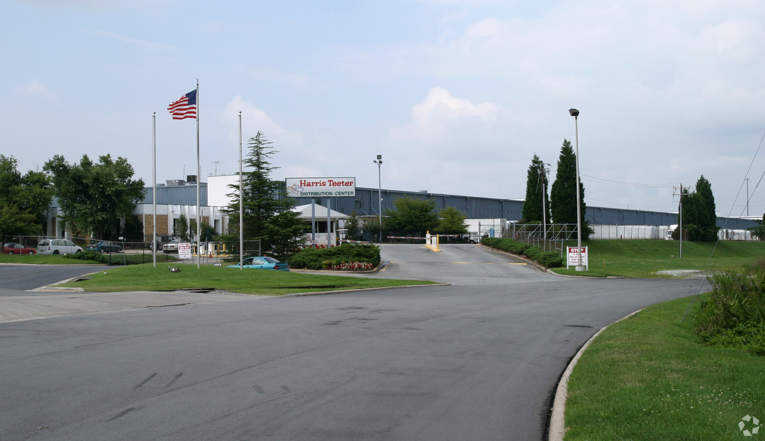
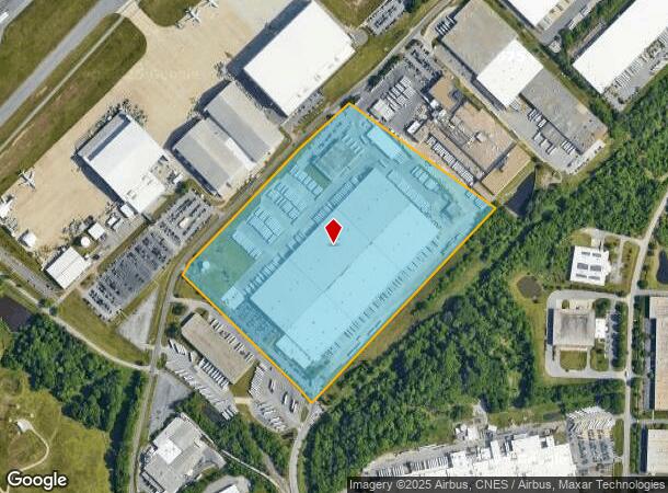
Property Record
200 Distribution Dr, Greensboro, NC 27410
NEARBY LISTINGS FOR SALE OR LEASE
Property Detail
200 Distribution Dr
Greensboro-High Point, NC
Tri-City Term
0099395
37.53 AC PB 52-5 TRI-CITY TERM
Industrialgeneral
Guilford
AE
North Carolina
3710782500J
16
2023
37.53 AC
2023
Airport/W Guilford County
980100
Greensboro/Winston-Salem
546,380 SF
DEMOGRAPHICS near 200 Distribution Dr
1 Mile
3 Mile
5 Mile
2024 Total Population
2,033
32,266
110,900
2029 Population
2,075
32,285
110,663
Pop Growth 2024-2029
+ 2.07%
+ 0.06%
(0.21%)
Average Age
34
40
40
2024 Total Households
1,073
15,610
48,496
HH Growth 2024-2029
+ 2.14%
+ 0.03%
(0.22%)
Median Household Inc
$37,196
$55,945
$72,458
Avg Household Size
1.90
2.00
2.20
2024 Avg HH Vehicles
1.00
2.00
2.00
Median Home Value
$103,488
$198,280
$250,676
Median Year Built
1997
1988
1991
Nearby Places
- Restaurants
- Banks
- Shops
- Fitness
- Groceries
PUBLIC TRANSPORTATION
AIRPORT
Piedmont Triad International
DRIVE
WALK
Distance
Piedmont Triad International
6 min
1.0 mi
Freight Ports
Virginia Port Authority - Richmond
DRIVE
WALK
Distance
Virginia Port Authority - Richmond
242 min
207.7 mi
Nearby Properties
Address
Land Use
TOTAL SIZE
Lot Size
Zoning
Address
Land Use
TOTAL SIZE
Lot Size
Zoning
747,867 SF
349.10 AC
PI
Address
Land Use
TOTAL SIZE
Lot Size
Zoning
21,687 SF
268.52 AC
HI
Address
Land Use
TOTAL SIZE
Lot Size
Zoning
404,766 SF
153.35 AC
AR
Address
Land Use
TOTAL SIZE
Lot Size
Zoning
501,140 SF
50.04 AC
R-3
Address
Land Use
TOTAL SIZE
Lot Size
Zoning
410,298 SF
33.10 AC
CU-RM-12
Address
Land Use
TOTAL SIZE
Lot Size
Zoning
462,568 SF
62.40 AC
BP
Address
Land Use
TOTAL SIZE
Lot Size
Zoning
691,408 SF
58.69 AC
LI
Address
Land Use
TOTAL SIZE
Lot Size
Zoning
340,508 SF
15.45 AC
RM-26
Address
Land Use
TOTAL SIZE
Lot Size
Zoning
374,522 SF
56.55 AC
HI
Address
Land Use
TOTAL SIZE
Lot Size
Zoning
186,200 SF
10.58 AC
LI
Address
Land Use
TOTAL SIZE
Lot Size
Zoning
367,819 SF
32.88 AC
CU-SC
Address
Land Use
TOTAL SIZE
Lot Size
Zoning
509,216 SF
40.85 AC
LI
Address
Land Use
TOTAL SIZE
Lot Size
Zoning
217,594 SF
20.01 AC
CU-RM-18
Address
Land Use
TOTAL SIZE
Lot Size
Zoning
245,192 SF
15.27 AC
CU-RM-12
Address
Land Use
TOTAL SIZE
Lot Size
Zoning
400,000 SF
46.72 AC
CU-LI
Address
Land Use
TOTAL SIZE
Lot Size
Zoning
358,900 SF
60.50 AC
PI
Address
Land Use
TOTAL SIZE
Lot Size
Zoning
229,103 SF
18.76 AC
CZ-I
Address
Land Use
TOTAL SIZE
Lot Size
Zoning
156,800 SF
30.81 AC
R-3
Address
Land Use
TOTAL SIZE
Lot Size
Zoning
316,205 SF
17.84 AC
CU-RM-18
Address
Land Use
TOTAL SIZE
Lot Size
Zoning
145,105 SF
20.12 AC
O
Address
Land Use
TOTAL SIZE
Lot Size
Zoning
309,749 SF
16.74 AC
CZ-PDM
Address
Land Use
TOTAL SIZE
Lot Size
Zoning
680,251 SF
52.92 AC
HI
Address
Land Use
TOTAL SIZE
Lot Size
Zoning
362,708 SF
56.81 AC
LI
Address
Land Use
TOTAL SIZE
Lot Size
Zoning
325.42 AC
AR
Address
Land Use
TOTAL SIZE
Lot Size
Zoning
180,568 SF
0.01 AC
AR
Address
Land Use
TOTAL SIZE
Lot Size
Zoning
311,199 SF
20.79 AC
CU-RM-12
Address
Land Use
TOTAL SIZE
Lot Size
Zoning
336,176 SF
31.73 AC
CU-SC
Address
Land Use
TOTAL SIZE
Lot Size
Zoning
341,000 SF
29.55 AC
CD-LI
Address
Land Use
TOTAL SIZE
Lot Size
Zoning
318,646 SF
28.27 AC
RM-12
Address
Land Use
TOTAL SIZE
Lot Size
Zoning
488,513 SF
37.16 AC
RM-18
The World's #1 Commercial Real Estate Marketplace
Connect with us
© 2025 CoStar Group
The information above has been obtained from sources believed reliable. While we do not doubt its accuracy we have not verified it and make no guarantee, warranty or representation about it. It is your responsibility to independently confirm its accuracy and completeness. Any projections, opinions, assumptions, or estimates used are for example only and do not represent the current or future performance of the property. The value of this transaction to you depends on tax and other factors which should be evaluated by your tax, financial, and legal advisors. You and your advisors should conduct a careful, independent investigation of the property to determine to your satisfaction the suitability of the property for your needs.