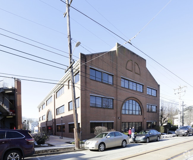
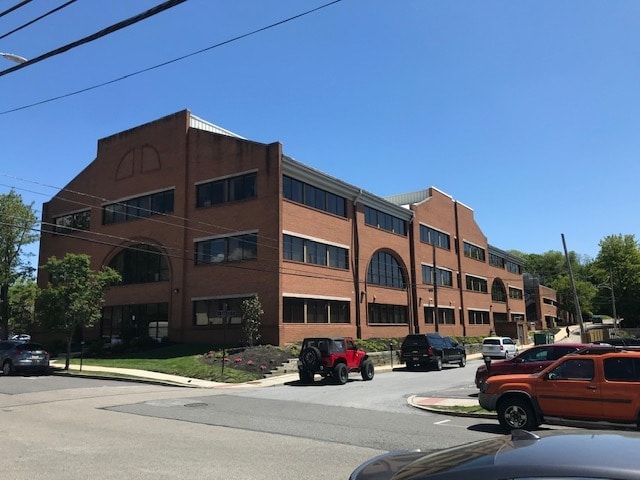
Property Record
200 E State St, Media, PA 19063
Current Lease Availabilities
NEARBY LISTINGS FOR SALE OR LEASE
Property Detail
200 E State St
26-00-01614-00
Property/Drexel Fleets Inc
Officebuilding
3STY BLDG 5LEV GAR 400 X 150
X
Delaware
42045C0092F
Pennsylvania
2024
1.38 AC
2025
Delaware County
407502
Philadelphia
54,619 SF
Philadelphia-Camden-Wilmington, PA-NJ-DE-MD
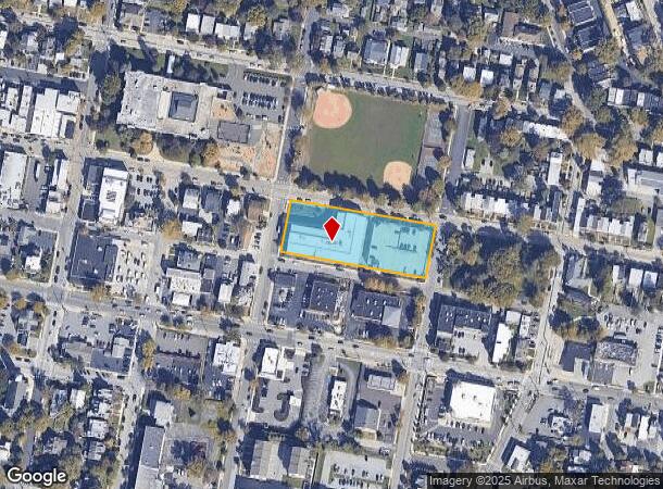
DEMOGRAPHICS near 200 E State St
1 Mile
3 Mile
5 Mile
2024 Total Population
13,184
69,359
262,515
2029 Population
13,094
68,725
260,612
Pop Growth 2024-2029
(0.68%)
(0.91%)
(0.72%)
Average Age
42
42
41
2024 Total Households
5,989
26,547
100,656
HH Growth 2024-2029
(0.78%)
(0.98%)
(0.77%)
Median Household Inc
$99,557
$114,087
$87,254
Avg Household Size
2.20
2.50
2.50
2024 Avg HH Vehicles
2.00
2.00
2.00
Median Home Value
$466,640
$406,645
$298,416
Median Year Built
1959
1960
1957
Nearby Places
Map Layers
Map Styles
 Street
 Aerial
- Restaurants
- Banks
- Shops
- Fitness
- Groceries
PUBLIC TRANSPORTATION
TRANSIT/SUBWAY
Edgemont Street (Route 101 - Southeastern Pennsylvania Transportation Authority Rapid Transit (SEPTA Subway & Trolley))
DRIVE
WALK
Distance
Edgemont Street (Route 101 - Southeastern Pennsylvania Transportation Authority Rapid Transit (SEPTA Subway & Trolley))
1 min
1 min
0.1 mi
Manchester Avenue (Route 101 - Southeastern Pennsylvania Transportation Authority Rapid Transit (SEPTA Subway & Trolley))
DRIVE
WALK
Distance
Manchester Avenue (Route 101 - Southeastern Pennsylvania Transportation Authority Rapid Transit (SEPTA Subway & Trolley))
1 min
3 min
0.2 mi
Monroe Street (Route 101 - Southeastern Pennsylvania Transportation Authority Rapid Transit (SEPTA Subway & Trolley))
DRIVE
WALK
Distance
Monroe Street (Route 101 - Southeastern Pennsylvania Transportation Authority Rapid Transit (SEPTA Subway & Trolley))
1 min
3 min
0.2 mi
Jackson Street (Route 101 - Southeastern Pennsylvania Transportation Authority Rapid Transit (SEPTA Subway & Trolley))
DRIVE
WALK
Distance
Jackson Street (Route 101 - Southeastern Pennsylvania Transportation Authority Rapid Transit (SEPTA Subway & Trolley))
2 min
5 min
0.3 mi
Bowling Green (Route 101 - Southeastern Pennsylvania Transportation Authority Rapid Transit (SEPTA Subway & Trolley))
DRIVE
WALK
Distance
Bowling Green (Route 101 - Southeastern Pennsylvania Transportation Authority Rapid Transit (SEPTA Subway & Trolley))
1 min
5 min
0.3 mi
COMMUTER RAIL
Media (R3 - Southeastern Pennsylvania Transportation Authority Regional Rail (SEPTA Regional Rail))
DRIVE
WALK
Distance
Media (R3 - Southeastern Pennsylvania Transportation Authority Regional Rail (SEPTA Regional Rail))
3 min
14 min
0.7 mi
Moylan-Rose Valley (R3 - Southeastern Pennsylvania Transportation Authority Regional Rail (SEPTA Regional Rail))
DRIVE
WALK
Distance
Moylan-Rose Valley (R3 - Southeastern Pennsylvania Transportation Authority Regional Rail (SEPTA Regional Rail))
3 min
18 min
0.9 mi
AIRPORT
Philadelphia International
DRIVE
WALK
Distance
Philadelphia International
19 min
10.4 mi
Freight Ports
Broadway Terminal - Pier 5
DRIVE
WALK
Distance
Broadway Terminal - Pier 5
34 min
21.3 mi
Nearby Properties
Address
Land Use
TOTAL SIZE
Lot Size
Zoning
Address
Land Use
TOTAL SIZE
Lot Size
Zoning
6,637 SF
198.92 AC
Address
Land Use
TOTAL SIZE
Lot Size
Zoning
86,400 SF
75 AC
Address
Land Use
TOTAL SIZE
Lot Size
Zoning
280,591 SF
2.76 AC
Address
Land Use
TOTAL SIZE
Lot Size
Zoning
38.39 AC
Address
Land Use
TOTAL SIZE
Lot Size
Zoning
48,739 SF
30 AC
Address
Land Use
TOTAL SIZE
Lot Size
Zoning
345,135 SF
37 AC
Address
Land Use
TOTAL SIZE
Lot Size
Zoning
175,000 SF
2.27 AC
Address
Land Use
TOTAL SIZE
Lot Size
Zoning
62,832 SF
39.05 AC
Address
Land Use
TOTAL SIZE
Lot Size
Zoning
137,640 SF
3.67 AC
Address
Land Use
TOTAL SIZE
Lot Size
Zoning
702,532 SF
11 AC
Address
Land Use
TOTAL SIZE
Lot Size
Zoning
268 AC
Address
Land Use
TOTAL SIZE
Lot Size
Zoning
312,988 SF
24 AC
Address
Land Use
TOTAL SIZE
Lot Size
Zoning
61,860 SF
6.29 AC
Address
Land Use
TOTAL SIZE
Lot Size
Zoning
61,536 SF
44 AC
Address
Land Use
TOTAL SIZE
Lot Size
Zoning
2,608 SF
198.92 AC
Address
Land Use
TOTAL SIZE
Lot Size
Zoning
2,562 SF
198.92 AC
Address
Land Use
TOTAL SIZE
Lot Size
Zoning
170,442 SF
26.04 AC
Address
Land Use
TOTAL SIZE
Lot Size
Zoning
12,100 SF
7 AC
Address
Land Use
TOTAL SIZE
Lot Size
Zoning
215,557 SF
22 AC
Address
Land Use
TOTAL SIZE
Lot Size
Zoning
261,618 SF
30.57 AC
Address
Land Use
TOTAL SIZE
Lot Size
Zoning
13,932 SF
9 AC
Address
Land Use
TOTAL SIZE
Lot Size
Zoning
702,532 SF
Address
Land Use
TOTAL SIZE
Lot Size
Zoning
63,515 SF
22.66 AC
Address
Land Use
TOTAL SIZE
Lot Size
Zoning
229,612 SF
6.05 AC
Address
Land Use
TOTAL SIZE
Lot Size
Zoning
76,600 SF
16.90 AC
Address
Land Use
TOTAL SIZE
Lot Size
Zoning
66,200 SF
Address
Land Use
TOTAL SIZE
Lot Size
Zoning
282,520 SF
24.44 AC
Address
Land Use
TOTAL SIZE
Lot Size
Zoning
37,176 SF
13 AC
Address
Land Use
TOTAL SIZE
Lot Size
Zoning
24,362 SF
5.63 AC
Address
Land Use
TOTAL SIZE
Lot Size
Zoning
38,220 SF
22.05 AC
The World's #1 Commercial Real Estate Marketplace
Connect with us
© 2025 CoStar Group
The information above has been obtained from sources believed reliable. While we do not doubt its accuracy we have not verified it and make no guarantee, warranty or representation about it. It is your responsibility to independently confirm its accuracy and completeness. Any projections, opinions, assumptions, or estimates used are for example only and do not represent the current or future performance of the property. The value of this transaction to you depends on tax and other factors which should be evaluated by your tax, financial, and legal advisors. You and your advisors should conduct a careful, independent investigation of the property to determine to your satisfaction the suitability of the property for your needs.