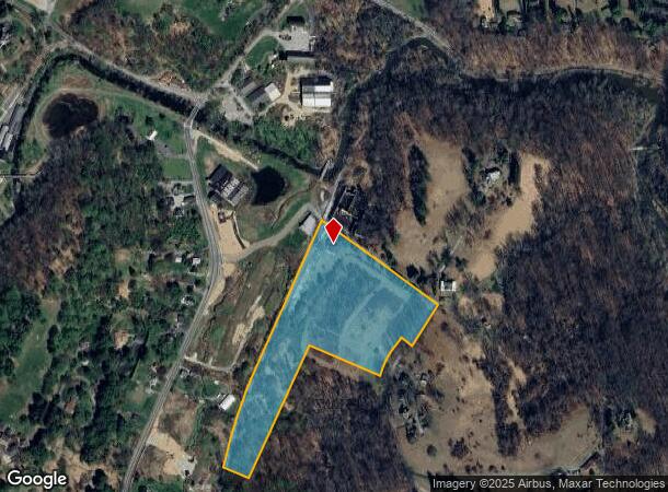
Property Record
200 Gun Club Rd, Hockessin, DE 19707

NEARBY LISTINGS FOR SALE OR LEASE
Property Detail
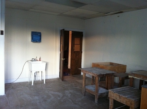
200 Gun Club Rd
08-004.00-267
Auburn Valley
Officebuilding
New Castle
X
Delaware
10003C0045L
b-2
2024
13.02 AC
2024
West New Castle County
013501
Philadelphia
3,795 SF
Philadelphia-Camden-Wilmington, PA-NJ-DE-MD
DEMOGRAPHICS near 200 Gun Club Rd
1 Mile
3 Mile
5 Mile
2024 Total Population
949
18,815
75,707
2029 Population
978
19,205
77,732
Pop Growth 2024-2029
+ 3.06%
+ 2.07%
+ 2.67%
Average Age
48
46
44
2024 Total Households
341
6,937
28,596
HH Growth 2024-2029
+ 3.23%
+ 2.16%
+ 2.73%
Median Household Inc
$176,923
$152,947
$122,704
Avg Household Size
2.60
2.60
2.60
2024 Avg HH Vehicles
2.00
2.00
2.00
Median Home Value
$517,857
$485,755
$450,335
Median Year Built
1975
1983
1982
Nearby Places
- Restaurants
- Banks
- Shops
- Fitness
- Groceries
PUBLIC TRANSPORTATION
AIRPORT
Philadelphia International
DRIVE
WALK
Distance
Philadelphia International
47 min
27.5 mi
Freight Ports
Port of Wilmington, RI
DRIVE
WALK
Distance
Port of Wilmington, RI
27 min
15.3 mi
Nearby Properties
Address
Land Use
TOTAL SIZE
Lot Size
Zoning
Address
Land Use
TOTAL SIZE
Lot Size
Zoning
32,831 SF
51.07 AC
NCPUD
Address
Land Use
TOTAL SIZE
Lot Size
Zoning
238,215 SF
35.70 AC
R3
Address
Land Use
TOTAL SIZE
Lot Size
Zoning
26,124 SF
24.21 AC
S
Address
Land Use
TOTAL SIZE
Lot Size
Zoning
121,027 SF
14.89 AC
S
Address
Land Use
TOTAL SIZE
Lot Size
Zoning
101,733 SF
85.55 AC
S
Address
Land Use
TOTAL SIZE
Lot Size
Zoning
4,522 SF
100.46 AC
SE
Address
Land Use
TOTAL SIZE
Lot Size
Zoning
67,453 SF
9.93 AC
ON
Address
Land Use
TOTAL SIZE
Lot Size
Zoning
175,250 SF
50 AC
SA
Address
Land Use
TOTAL SIZE
Lot Size
Zoning
18,489 SF
180.78 AC
SE
Address
Land Use
TOTAL SIZE
Lot Size
Zoning
42,710 SF
2.87 AC
ON
Address
Land Use
TOTAL SIZE
Lot Size
Zoning
108,829 SF
11.80 AC
SA
Address
Land Use
TOTAL SIZE
Lot Size
Zoning
21,511 SF
11 AC
S
Address
Land Use
TOTAL SIZE
Lot Size
Zoning
15,376 SF
68.36 AC
SE
Address
Land Use
TOTAL SIZE
Lot Size
Zoning
945 SF
13.38 AC
S
Address
Land Use
TOTAL SIZE
Lot Size
Zoning
118,592 SF
12 AC
SA
Address
Land Use
TOTAL SIZE
Lot Size
Zoning
34,066 SF
14.39 AC
S
Address
Land Use
TOTAL SIZE
Lot Size
Zoning
20,032 SF
17.71 AC
SE
Address
Land Use
TOTAL SIZE
Lot Size
Zoning
61,200 SF
5.63 AC
R3
Address
Land Use
TOTAL SIZE
Lot Size
Zoning
9,848 SF
3.90 AC
CR
Address
Land Use
TOTAL SIZE
Lot Size
Zoning
2,173 SF
173.44 AC
SE
Address
Land Use
TOTAL SIZE
Lot Size
Zoning
86,184 SF
12 AC
SA
Address
Land Use
TOTAL SIZE
Lot Size
Zoning
63,013 SF
6.12 AC
S
Address
Land Use
TOTAL SIZE
Lot Size
Zoning
36,874 SF
7.02 AC
NC6.5
Address
Land Use
TOTAL SIZE
Lot Size
Zoning
33,328 SF
2.49 AC
S
Address
Land Use
TOTAL SIZE
Lot Size
Zoning
47,414 SF
5.23 AC
R3
Address
Land Use
TOTAL SIZE
Lot Size
Zoning
32,717 SF
6.13 AC
CN
Address
Land Use
TOTAL SIZE
Lot Size
Zoning
21,508 SF
2.43 AC
CR
Address
Land Use
TOTAL SIZE
Lot Size
Zoning
102,120 SF
1.18 AC
CR
Address
Land Use
TOTAL SIZE
Lot Size
Zoning
7,457 SF
125.20 AC
R1
Address
Land Use
TOTAL SIZE
Lot Size
Zoning
16,062 SF
4.61 AC
S
The World's #1 Commercial Real Estate Marketplace
Connect with us
© 2025 CoStar Group
The information above has been obtained from sources believed reliable. While we do not doubt its accuracy we have not verified it and make no guarantee, warranty or representation about it. It is your responsibility to independently confirm its accuracy and completeness. Any projections, opinions, assumptions, or estimates used are for example only and do not represent the current or future performance of the property. The value of this transaction to you depends on tax and other factors which should be evaluated by your tax, financial, and legal advisors. You and your advisors should conduct a careful, independent investigation of the property to determine to your satisfaction the suitability of the property for your needs.